Property Record
12100 S Pflumm Rd, Olathe, KS 66062
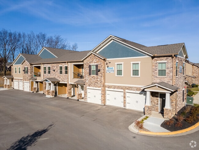

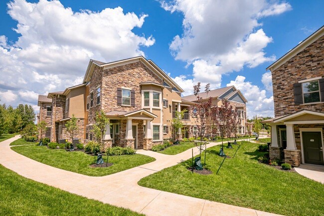
Property Detail
12100 S Pflumm Rd
DP16480000-0001
DAVIS DEVELOPMENT APARTMENTS OLATHE, LOT 1, EX BG NE CR S 14.67 NW 33.05 E 29.68 TO POB IN ST
Apartment
Johnson
NC
Kansas
B and X Area of moderate flood hazard, usually the area between the limits of the 100-year and 500-year floods.
1
2024
27.25 AC
2025
Outlying Johnson County KS
053007
Kansas City
89,702 SF
Kansas City, MO-KS
NEARBY LISTINGS FOR SALE OR LEASE
DEMOGRAPHICS near 12100 S Pflumm Rd
1 mile
3 mile
5 mile
2025 Total Population
13,796
90,890
247,516
2030 Population
14,217
93,653
254,837
Pop Growth 2025-2030
+ 3.05%
+ 3.04%
+ 2.96%
Average Age
41
40
40
2025 Total Households
6,155
37,570
99,221
HH Growth 2025-2030
+ 2.81%
+ 3.08%
+ 3.13%
Median Household Inc
$97,925
$98,423
$99,597
Avg Household Size
2.20
2.40
2.40
2025 Avg HH Vehicles
2.00
2.00
2.00
Median Home Value
$409,526
$385,780
$368,083
Median Year Built
1995
1992
1989
Nearby Places
Map Layers
Map Styles
 Street
 Aerial
Transit
 Traffic
 Biking
Places
Listings with unknown addresses are not visible on the map
- Restaurants
- Banks
- Shops
- Fitness
- Groceries
PUBLIC TRANSPORTATION
AIRPORT
Kansas City International
Drive
Walk
Distance
Kansas City International
47 min
35.5 mi
Freight Ports
Tulsa Port Of Catoosa
Drive
Walk
Distance
Tulsa Port Of Catoosa
251 min
224.4 mi
Nearby Properties
Address
Land Use
TOTAL SIZE
Lot Size
Zoning
Address
Land Use
TOTAL SIZE
Lot Size
Zoning
1,051,458 SF
74.32 AC
R-1
Address
Land Use
TOTAL SIZE
Lot Size
Zoning
312,726 SF
13.73 AC
RP-4
Address
Land Use
TOTAL SIZE
Lot Size
Zoning
482,713 SF
77.78 AC
AG
Address
Land Use
TOTAL SIZE
Lot Size
Zoning
114,689 SF
60.46 AC
R-1
Address
Land Use
TOTAL SIZE
Lot Size
Zoning
247,991 SF
21.19 AC
R-1
Address
Land Use
TOTAL SIZE
Lot Size
Zoning
293,337 SF
38.50 AC
R-1
Address
Land Use
TOTAL SIZE
Lot Size
Zoning
635,676 SF
30.59 AC
BP2
Address
Land Use
TOTAL SIZE
Lot Size
Zoning
564,948 SF
27.40 AC
AG
Address
Land Use
TOTAL SIZE
Lot Size
Zoning
606,171 SF
31 AC
BP2
Address
Land Use
TOTAL SIZE
Lot Size
Zoning
211,785 SF
35.56 AC
RP-3
Address
Land Use
TOTAL SIZE
Lot Size
Zoning
40,647 SF
7.40 AC
R-4
Address
Land Use
TOTAL SIZE
Lot Size
Zoning
195,167 SF
15.55 AC
R-1
Address
Land Use
TOTAL SIZE
Lot Size
Zoning
148,018 SF
7.14 AC
MXD
Address
Land Use
TOTAL SIZE
Lot Size
Zoning
199,452 SF
29.81 AC
R-1
Address
Land Use
TOTAL SIZE
Lot Size
Zoning
144,755 SF
22.19 AC
BP2
Address
Land Use
TOTAL SIZE
Lot Size
Zoning
512,680 SF
18.03 AC
R-1
Address
Land Use
TOTAL SIZE
Lot Size
Zoning
202,726 SF
9.37 AC
R-1
Address
Land Use
TOTAL SIZE
Lot Size
Zoning
404,388 SF
21.55 AC
BP2
Address
Land Use
TOTAL SIZE
Lot Size
Zoning
222,396 SF
14.76 AC
BP2
Address
Land Use
TOTAL SIZE
Lot Size
Zoning
32,992 SF
3.85 AC
R-4
Address
Land Use
TOTAL SIZE
Lot Size
Zoning
62,293 SF
6.50 AC
MXD
Address
Land Use
TOTAL SIZE
Lot Size
Zoning
135,551 SF
12.36 AC
R-1
Address
Land Use
TOTAL SIZE
Lot Size
Zoning
89,226 SF
4.37 AC
R-1
Address
Land Use
TOTAL SIZE
Lot Size
Zoning
347,324 SF
18.16 AC
BP2
Address
Land Use
TOTAL SIZE
Lot Size
Zoning
107,857 SF
10.94 AC
C-2
Address
Land Use
TOTAL SIZE
Lot Size
Zoning
146,832 SF
30 AC
R-1
Address
Land Use
TOTAL SIZE
Lot Size
Zoning
150,122 SF
17.48 AC
R-1
Address
Land Use
TOTAL SIZE
Lot Size
Zoning
94,034 SF
6.96 AC
MXD
Address
Land Use
TOTAL SIZE
Lot Size
Zoning
249,780 SF
15.75 AC
BP2
Address
Land Use
TOTAL SIZE
Lot Size
Zoning
81,820 SF
15.16 AC
R-1
The World's #1 Commercial Real Estate Marketplace
Connect with us
© 2026 CoStar Group
The information above has been obtained from sources believed reliable. While we do not doubt its accuracy we have not verified it and make no guarantee, warranty or representation about it. It is your responsibility to independently confirm its accuracy and completeness. Any projections, opinions, assumptions, or estimates used are for example only and do not represent the current or future performance of the property. The value of this transaction to you depends on tax and other factors which should be evaluated by your tax, financial, and legal advisors. You and your advisors should conduct a careful, independent investigation of the property to determine to your satisfaction the suitability of the property for your needs.