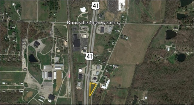
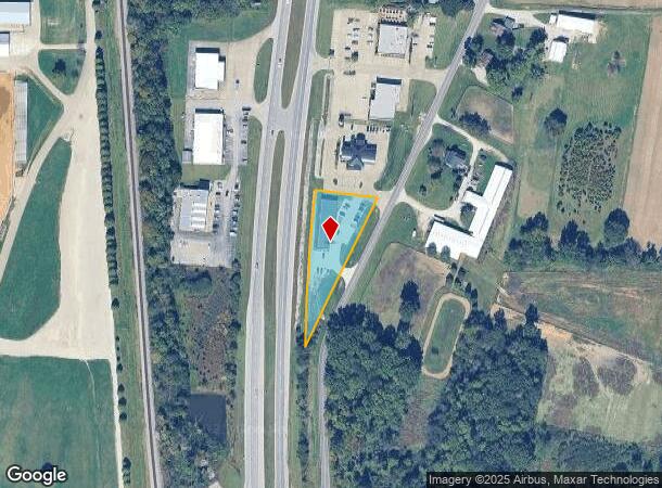
Property Record
12101 Highway 41 N, Evansville, IN 47725
NEARBY LISTINGS FOR SALE OR LEASE
-
-
View all Evansville listings for sale on LoopNet.com
Property Detail
12101 Highway 41 N
Evansville, IN-KY
Sheffer Carson Plaza Amended Plat Ii
82-04-17-009-373.005-030
SHEFFER CARSON PLAZA AMENDED PLAT II LOT 5
Stripcommercialcenter
Vanderburgh
X
Indiana
18163C0108D
5
2024
0.93 AC
2024
Northside/Airport
010702
Evansville
5,060 SF
DEMOGRAPHICS near 12101 Highway 41 N
1 Mile
3 Mile
5 Mile
2024 Total Population
1,229
16,832
39,329
2029 Population
1,224
16,724
39,072
Pop Growth 2024-2029
(0.41%)
(0.64%)
(0.65%)
Average Age
43
41
41
2024 Total Households
467
6,290
15,089
HH Growth 2024-2029
(0.64%)
(0.65%)
(0.68%)
Median Household Inc
$110,156
$97,039
$84,693
Avg Household Size
2.60
2.60
2.50
2024 Avg HH Vehicles
2.00
2.00
2.00
Median Home Value
$301,852
$253,140
$205,957
Median Year Built
1991
1994
1990
Nearby Places
Map Layers
Map Styles
 Street
 Aerial
- Restaurants
- Banks
- Shops
- Fitness
- Groceries
PUBLIC TRANSPORTATION
AIRPORT
Evansville Regional
DRIVE
WALK
Distance
Evansville Regional
10 min
6.0 mi
Freight Ports
Port of Toledo
DRIVE
WALK
Distance
Port of Toledo
448 min
386.3 mi
SALE & LEASE HISTORY
LISTING DATE
SALE/LEASE

Jan 18, 2017
For Sale
Nearby Properties
Address
Land Use
TOTAL SIZE
Lot Size
Zoning
Address
Land Use
TOTAL SIZE
Lot Size
Zoning
1,785 SF
70.87 AC
5
Address
Land Use
TOTAL SIZE
Lot Size
Zoning
253,580 SF
41.82 AC
5
Address
Land Use
TOTAL SIZE
Lot Size
Zoning
990 SF
48.21 AC
Address
Land Use
TOTAL SIZE
Lot Size
Zoning
73,423 SF
9.97 AC
Address
Land Use
TOTAL SIZE
Lot Size
Zoning
298,374 SF
18.16 AC
Address
Land Use
TOTAL SIZE
Lot Size
Zoning
55,870 SF
6.30 AC
Address
Land Use
TOTAL SIZE
Lot Size
Zoning
31,669 SF
8.55 AC
Address
Land Use
TOTAL SIZE
Lot Size
Zoning
227,968 SF
11.05 AC
Address
Land Use
TOTAL SIZE
Lot Size
Zoning
9,250 SF
8.57 AC
Address
Land Use
TOTAL SIZE
Lot Size
Zoning
46,876 SF
12.78 AC
Address
Land Use
TOTAL SIZE
Lot Size
Zoning
50,751 SF
7.04 AC
4
Address
Land Use
TOTAL SIZE
Lot Size
Zoning
22,794 SF
6.39 AC
Address
Land Use
TOTAL SIZE
Lot Size
Zoning
143,507 SF
27.98 AC
55
Address
Land Use
TOTAL SIZE
Lot Size
Zoning
215,153 SF
11.95 AC
Address
Land Use
TOTAL SIZE
Lot Size
Zoning
115,127 SF
5.14 AC
Address
Land Use
TOTAL SIZE
Lot Size
Zoning
18,117 SF
12.41 AC
Address
Land Use
TOTAL SIZE
Lot Size
Zoning
1,200 SF
26 AC
Address
Land Use
TOTAL SIZE
Lot Size
Zoning
8,740 SF
5.97 AC
4
Address
Land Use
TOTAL SIZE
Lot Size
Zoning
30,270 SF
2.84 AC
Address
Land Use
TOTAL SIZE
Lot Size
Zoning
3,591 SF
1.62 AC
Address
Land Use
TOTAL SIZE
Lot Size
Zoning
34,020 SF
2.67 AC
Address
Land Use
TOTAL SIZE
Lot Size
Zoning
15,359 SF
2.43 AC
Address
Land Use
TOTAL SIZE
Lot Size
Zoning
118,680 SF
7.89 AC
Address
Land Use
TOTAL SIZE
Lot Size
Zoning
49,160 SF
12.42 AC
4
Address
Land Use
TOTAL SIZE
Lot Size
Zoning
13,334 SF
1.69 AC
1
Address
Land Use
TOTAL SIZE
Lot Size
Zoning
15,210 SF
7.22 AC
Address
Land Use
TOTAL SIZE
Lot Size
Zoning
26,000 SF
8.29 AC
Address
Land Use
TOTAL SIZE
Lot Size
Zoning
22,562 SF
9.28 AC
Address
Land Use
TOTAL SIZE
Lot Size
Zoning
31,005 SF
3.31 AC
Address
Land Use
TOTAL SIZE
Lot Size
Zoning
5,626 SF
1.91 AC
The World's #1 Commercial Real Estate Marketplace
Connect with us
© 2025 CoStar Group
The information above has been obtained from sources believed reliable. While we do not doubt its accuracy we have not verified it and make no guarantee, warranty or representation about it. It is your responsibility to independently confirm its accuracy and completeness. Any projections, opinions, assumptions, or estimates used are for example only and do not represent the current or future performance of the property. The value of this transaction to you depends on tax and other factors which should be evaluated by your tax, financial, and legal advisors. You and your advisors should conduct a careful, independent investigation of the property to determine to your satisfaction the suitability of the property for your needs.