Property Record
12108 Interstate 20 W, Tyler, TX 75706
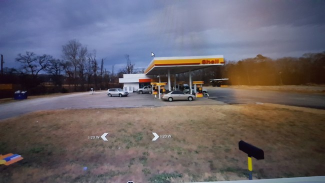


Property Detail
12108 Interstate 20 W
1-00000-0019-01-045050
ABST A0019 P DEL RIOTRACT 45E S01
Servicestationmarket
Smith
A Areas with a 1% annual chance of flooding and a 26% chance of flooding over the life of a 30-year mortgage.
Texas
2025
1 AC
2025
Winona
001605
Other Market Areas
1,040 SF
Tyler, TX
NEARBY LISTINGS FOR SALE OR LEASE
DEMOGRAPHICS near 12108 Interstate 20 W
1 mile
3 mile
5 mile
2025 Total Population
650
5,676
19,817
2030 Population
699
6,078
21,171
Pop Growth 2025-2030
+ 7.54%
+ 7.08%
+ 6.83%
Average Age
37
38
39
2025 Total Households
231
1,975
7,009
HH Growth 2025-2030
+ 6.93%
+ 6.68%
+ 6.35%
Median Household Inc
$51,667
$85,980
$84,895
Avg Household Size
2.80
2.80
2.70
2025 Avg HH Vehicles
3.00
2.00
2.00
Median Home Value
$551,075
$340,039
$281,323
Median Year Built
2009
1999
1992
Nearby Places
Map Layers
Map Styles
 Street
 Aerial
Transit
 Traffic
 Biking
Places
Listings with unknown addresses are not visible on the map
- Restaurants
- Banks
- Shops
- Fitness
- Groceries
PUBLIC TRANSPORTATION
AIRPORT
Tyler Pounds Regional
Drive
Walk
Distance
Tyler Pounds Regional
21 min
14.0 mi
Freight Ports
Port of Shreveport
Drive
Walk
Distance
Port of Shreveport
119 min
108.0 mi
SALE & LEASE HISTORY
LISTING DATE
SALE/LEASE

Oct 18, 2018
For Sale
May 14, 2020
For Sale
Dec 04, 2018
For Lease
Apr 26, 2019
For Sale
Nearby Properties
Address
Land Use
TOTAL SIZE
Lot Size
Zoning
Address
Land Use
TOTAL SIZE
Lot Size
Zoning
1,680,000 SF
145.53 AC
Address
Land Use
TOTAL SIZE
Lot Size
Zoning
15,436 SF
7.66 AC
Address
Land Use
TOTAL SIZE
Lot Size
Zoning
32,238 SF
10.61 AC
Address
Land Use
TOTAL SIZE
Lot Size
Zoning
156,758 SF
21.96 AC
Address
Land Use
TOTAL SIZE
Lot Size
Zoning
995 SF
7.93 AC
Address
Land Use
TOTAL SIZE
Lot Size
Zoning
136,846 SF
15.10 AC
Address
Land Use
TOTAL SIZE
Lot Size
Zoning
95,278 SF
4.60 AC
Address
Land Use
TOTAL SIZE
Lot Size
Zoning
3,200 SF
3.47 AC
Address
Land Use
TOTAL SIZE
Lot Size
Zoning
17,077 SF
4.72 AC
Address
Land Use
TOTAL SIZE
Lot Size
Zoning
36,519 SF
3.18 AC
Address
Land Use
TOTAL SIZE
Lot Size
Zoning
7,822 SF
7.59 AC
Address
Land Use
TOTAL SIZE
Lot Size
Zoning
11,532 SF
2.24 AC
Address
Land Use
TOTAL SIZE
Lot Size
Zoning
15,292 SF
2 AC
Address
Land Use
TOTAL SIZE
Lot Size
Zoning
17,125 SF
44 AC
Address
Land Use
TOTAL SIZE
Lot Size
Zoning
19,600 SF
2.76 AC
Address
Land Use
TOTAL SIZE
Lot Size
Zoning
41,612 SF
1.50 AC
Address
Land Use
TOTAL SIZE
Lot Size
Zoning
7,071 SF
2.76 AC
Address
Land Use
TOTAL SIZE
Lot Size
Zoning
1,566 SF
2.77 AC
Address
Land Use
TOTAL SIZE
Lot Size
Zoning
10,164 SF
0.91 AC
Address
Land Use
TOTAL SIZE
Lot Size
Zoning
4,200 SF
3.10 AC
Address
Land Use
TOTAL SIZE
Lot Size
Zoning
1,880 SF
2.94 AC
Address
Land Use
TOTAL SIZE
Lot Size
Zoning
10,850 SF
3.18 AC
Address
Land Use
TOTAL SIZE
Lot Size
Zoning
4,108 SF
1 AC
Address
Land Use
TOTAL SIZE
Lot Size
Zoning
4,851 SF
1.98 AC
Address
Land Use
TOTAL SIZE
Lot Size
Zoning
5,894 SF
1.47 AC
Address
Land Use
TOTAL SIZE
Lot Size
Zoning
12,412 SF
1.62 AC
Address
Land Use
TOTAL SIZE
Lot Size
Zoning
3.10 AC
Address
Land Use
TOTAL SIZE
Lot Size
Zoning
9,708 SF
2.76 AC
Address
Land Use
TOTAL SIZE
Lot Size
Zoning
6,689 SF
4.90 AC
Address
Land Use
TOTAL SIZE
Lot Size
Zoning
8.24 AC
The World's #1 Commercial Real Estate Marketplace
Connect with us
© 2026 CoStar Group
The information above has been obtained from sources believed reliable. While we do not doubt its accuracy we have not verified it and make no guarantee, warranty or representation about it. It is your responsibility to independently confirm its accuracy and completeness. Any projections, opinions, assumptions, or estimates used are for example only and do not represent the current or future performance of the property. The value of this transaction to you depends on tax and other factors which should be evaluated by your tax, financial, and legal advisors. You and your advisors should conduct a careful, independent investigation of the property to determine to your satisfaction the suitability of the property for your needs.