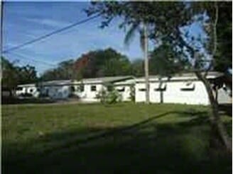
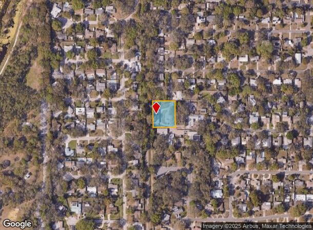
Property Record
1211 10Th St Sw, Largo, FL 33770

NEARBY LISTINGS FOR SALE OR LEASE
Property Detail
1211 10Th St Sw
04-30-15-00000-140-0500
Fr Nw Cor Of Se 1/4 Of Ne
Lightindustrial
FR NW COR OF SE 1/4 OF NE 1/4 RUN E 164.28FT FOR POB TH S 178.01FT TH W 148.3FT TH N 177FT TH E 148.3FT TO POB
X
Pinellas
12103C0118H
Florida
2024
0.62 AC
2025
South Pinellas
025309
Tampa/St Petersburg
4,470 SF
Tampa-St. Petersburg-Clearwater, FL
DEMOGRAPHICS near 1211 10Th St Sw
1 Mile
3 Mile
5 Mile
2024 Total Population
14,428
99,196
236,609
2029 Population
14,476
99,714
238,515
Pop Growth 2024-2029
+ 0.33%
+ 0.52%
+ 0.81%
Average Age
47
48
47
2024 Total Households
6,754
46,412
108,862
HH Growth 2024-2029
+ 0.34%
+ 0.39%
+ 0.82%
Median Household Inc
$54,443
$57,165
$60,791
Avg Household Size
2.10
2.00
2.10
2024 Avg HH Vehicles
1.00
2.00
2.00
Median Home Value
$237,218
$256,462
$287,547
Median Year Built
1974
1974
1975
Nearby Places
Map Layers
Map Styles
 Street
 Aerial
- Restaurants
- Banks
- Shops
- Fitness
- Groceries
PUBLIC TRANSPORTATION
AIRPORT
St Pete-Clearwater International
DRIVE
WALK
Distance
St Pete-Clearwater International
24 min
10.5 mi
Tampa International
DRIVE
WALK
Distance
Tampa International
37 min
21.9 mi
Freight Ports
Port of Tampa Bay
DRIVE
WALK
Distance
Port of Tampa Bay
45 min
27.3 mi
Nearby Properties
Address
Land Use
TOTAL SIZE
Lot Size
Zoning
Address
Land Use
TOTAL SIZE
Lot Size
Zoning
537,958 SF
41.61 AC
C2
Address
Land Use
TOTAL SIZE
Lot Size
Zoning
529,506 SF
23.06 AC
Address
Land Use
TOTAL SIZE
Lot Size
Zoning
520,871 SF
29 AC
R6
Address
Land Use
TOTAL SIZE
Lot Size
Zoning
367,081 SF
13.80 AC
Address
Land Use
TOTAL SIZE
Lot Size
Zoning
333,425 SF
33.66 AC
Address
Land Use
TOTAL SIZE
Lot Size
Zoning
318,185 SF
38.78 AC
C2
Address
Land Use
TOTAL SIZE
Lot Size
Zoning
305,592 SF
9.65 AC
C2
Address
Land Use
TOTAL SIZE
Lot Size
Zoning
588,657 SF
33 AC
Address
Land Use
TOTAL SIZE
Lot Size
Zoning
509,129 SF
18.74 AC
Address
Land Use
TOTAL SIZE
Lot Size
Zoning
290,269 SF
8.49 AC
Address
Land Use
TOTAL SIZE
Lot Size
Zoning
321,140 SF
18.02 AC
Address
Land Use
TOTAL SIZE
Lot Size
Zoning
545,062 SF
8.37 AC
Address
Land Use
TOTAL SIZE
Lot Size
Zoning
294,101 SF
22.55 AC
Address
Land Use
TOTAL SIZE
Lot Size
Zoning
296,919 SF
39.10 AC
Address
Land Use
TOTAL SIZE
Lot Size
Zoning
241,547 SF
9.27 AC
Address
Land Use
TOTAL SIZE
Lot Size
Zoning
198,688 SF
11.99 AC
Address
Land Use
TOTAL SIZE
Lot Size
Zoning
280,129 SF
Address
Land Use
TOTAL SIZE
Lot Size
Zoning
319,725 SF
9.14 AC
Address
Land Use
TOTAL SIZE
Lot Size
Zoning
84,057 SF
34.26 AC
Address
Land Use
TOTAL SIZE
Lot Size
Zoning
261,486 SF
30.21 AC
RPD20
Address
Land Use
TOTAL SIZE
Lot Size
Zoning
194,610 SF
36.55 AC
R3
Address
Land Use
TOTAL SIZE
Lot Size
Zoning
129,600 SF
7.09 AC
Address
Land Use
TOTAL SIZE
Lot Size
Zoning
6,098 SF
374.66 AC
AE
Address
Land Use
TOTAL SIZE
Lot Size
Zoning
157,904 SF
0.57 AC
Address
Land Use
TOTAL SIZE
Lot Size
Zoning
186,391 SF
11.86 AC
Address
Land Use
TOTAL SIZE
Lot Size
Zoning
194,748 SF
12.69 AC
M1
Address
Land Use
TOTAL SIZE
Lot Size
Zoning
157,769 SF
4.47 AC
Address
Land Use
TOTAL SIZE
Lot Size
Zoning
283,033 SF
12.72 AC
Address
Land Use
TOTAL SIZE
Lot Size
Zoning
160,328 SF
8.15 AC
Address
Land Use
TOTAL SIZE
Lot Size
Zoning
152,088 SF
92.28 AC
PC
The World's #1 Commercial Real Estate Marketplace
Connect with us
© 2025 CoStar Group
The information above has been obtained from sources believed reliable. While we do not doubt its accuracy we have not verified it and make no guarantee, warranty or representation about it. It is your responsibility to independently confirm its accuracy and completeness. Any projections, opinions, assumptions, or estimates used are for example only and do not represent the current or future performance of the property. The value of this transaction to you depends on tax and other factors which should be evaluated by your tax, financial, and legal advisors. You and your advisors should conduct a careful, independent investigation of the property to determine to your satisfaction the suitability of the property for your needs.