Property Record
1211 E Conway St, Milwaukee, WI 53207
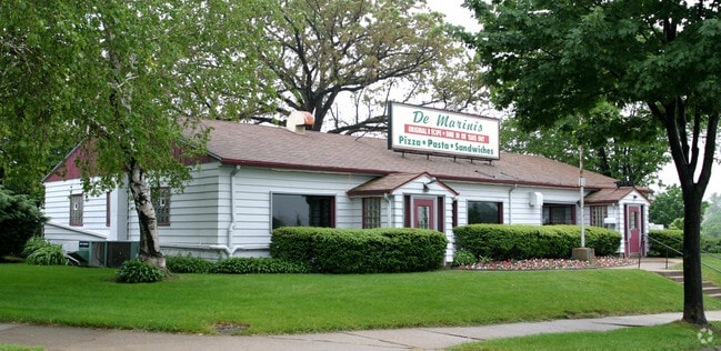

Property Detail
1211 E Conway St
501-0361-000-9
VILLAGE OF BAY VIEW IN NE 1/4 SEC 9 & NW 1/4 SEC 10-6-22 BLOCK 10 (LOTS 1-2 & 3) EXC ST & VAC ST & ALLEY ADJ
Restaurantbuilding
Milwaukee
LB2
Wisconsin
B and X Area of moderate flood hazard, usually the area between the limits of the 100-year and 500-year floods.
1-2,3
2024
0.36 AC
2024
Milwaukee SE
018000
Milwaukee/Madison
3,427 SF
Milwaukee-Waukesha, WI
NEARBY LISTINGS FOR SALE OR LEASE
DEMOGRAPHICS near 1211 E Conway St
1 mile
3 mile
5 mile
2025 Total Population
12,032
120,102
306,561
2030 Population
11,786
117,338
302,869
Pop Growth 2025-2030
(2.04%)
(2.30%)
(1.20%)
Average Age
39
36
36
2025 Total Households
6,099
49,012
132,610
HH Growth 2025-2030
(2.13%)
(1.87%)
(0.95%)
Median Household Inc
$91,626
$61,762
$57,271
Avg Household Size
1.90
2.30
2.20
2025 Avg HH Vehicles
1.00
1.00
1.00
Median Home Value
$281,159
$205,334
$212,644
Median Year Built
1946
1947
1949
Nearby Places
Map Layers
Map Styles
 Street
 Aerial
Layers
 Traffic
 Biking
Places
Listings with unknown addresses are not visible on the map
- Restaurants
- Banks
- Shops
- Fitness
- Groceries
PUBLIC TRANSPORTATION
COMMUTER RAIL
Drive
Walk
Distance
8 min
3.9 mi
Drive
Walk
Distance
15 min
5.3 mi
AIRPORT
General Mitchell International
Drive
Walk
Distance
General Mitchell International
13 min
4.6 mi
Nearby Properties
Address
Land Use
TOTAL SIZE
Lot Size
Zoning
Address
Land Use
TOTAL SIZE
Lot Size
Zoning
1,140,196 SF
5.33 AC
C9F(A)
Address
Land Use
TOTAL SIZE
Lot Size
Zoning
1,330,372 SF
2.48 AC
C9F(A)
Address
Land Use
TOTAL SIZE
Lot Size
Zoning
41.05 AC
IO2
Address
Land Use
TOTAL SIZE
Lot Size
Zoning
715,000 SF
2.71 AC
C9F(B)
Address
Land Use
TOTAL SIZE
Lot Size
Zoning
523,726 SF
0.79 AC
C9B(B)
Address
Land Use
TOTAL SIZE
Lot Size
Zoning
607,577 SF
1.67 AC
PD
Address
Land Use
TOTAL SIZE
Lot Size
Zoning
370,160 SF
2.93 AC
C9F(A)
Address
Land Use
TOTAL SIZE
Lot Size
Zoning
380,817 SF
0.82 AC
C9F(A)
Address
Land Use
TOTAL SIZE
Lot Size
Zoning
362,007 SF
1.02 AC
C9F(A)
Address
Land Use
TOTAL SIZE
Lot Size
Zoning
495,212 SF
0.48 AC
C9F(A)
Address
Land Use
TOTAL SIZE
Lot Size
Zoning
414,410 SF
2.16 AC
C9F(A)
Address
Land Use
TOTAL SIZE
Lot Size
Zoning
173,610 SF
1.70 AC
IM
Address
Land Use
TOTAL SIZE
Lot Size
Zoning
378,717 SF
0.61 AC
C9D(A)
Address
Land Use
TOTAL SIZE
Lot Size
Zoning
491,759 SF
3 AC
C9F(A)
Address
Land Use
TOTAL SIZE
Lot Size
Zoning
272,475 SF
0.66 AC
PD
Address
Land Use
TOTAL SIZE
Lot Size
Zoning
319,559 SF
6.29 AC
PD
Address
Land Use
TOTAL SIZE
Lot Size
Zoning
4.53 AC
C9F(A)
Address
Land Use
TOTAL SIZE
Lot Size
Zoning
425,000 SF
1.42 AC
C9F(A)
Address
Land Use
TOTAL SIZE
Lot Size
Zoning
179 AC
IH
Address
Land Use
TOTAL SIZE
Lot Size
Zoning
391,430 SF
0.99 AC
C9F(B)
Address
Land Use
TOTAL SIZE
Lot Size
Zoning
11.09 AC
Address
Land Use
TOTAL SIZE
Lot Size
Zoning
204,809 SF
1.04 AC
IM
Address
Land Use
TOTAL SIZE
Lot Size
Zoning
245,485 SF
6.30 AC
IM
Address
Land Use
TOTAL SIZE
Lot Size
Zoning
216,500 SF
0.03 AC
C9F(A)
Address
Land Use
TOTAL SIZE
Lot Size
Zoning
0.86 AC
C9F(A)
Address
Land Use
TOTAL SIZE
Lot Size
Zoning
166,554 SF
0.66 AC
C9F(A)
Address
Land Use
TOTAL SIZE
Lot Size
Zoning
1,709,128 SF
9.32 AC
PD
Address
Land Use
TOTAL SIZE
Lot Size
Zoning
12.02 AC
IO2
Address
Land Use
TOTAL SIZE
Lot Size
Zoning
147,010 SF
0.76 AC
C9F(A)
Address
Land Use
TOTAL SIZE
Lot Size
Zoning
322,007 SF
1.25 AC
C9F(A)
The World's #1 Commercial Real Estate Marketplace
Connect with us
© 2026 CoStar Group
The information above has been obtained from sources believed reliable. While we do not doubt its accuracy we have not verified it and make no guarantee, warranty or representation about it. It is your responsibility to independently confirm its accuracy and completeness. Any projections, opinions, assumptions, or estimates used are for example only and do not represent the current or future performance of the property. The value of this transaction to you depends on tax and other factors which should be evaluated by your tax, financial, and legal advisors. You and your advisors should conduct a careful, independent investigation of the property to determine to your satisfaction the suitability of the property for your needs.