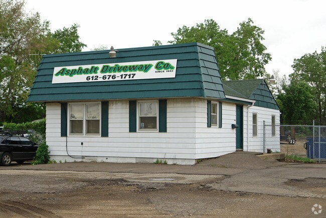
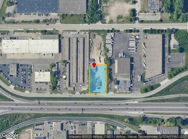
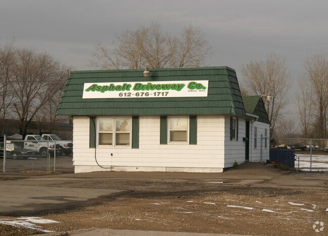
Property Record
1211 Viking Dr E, Maplewood, MN 55109
NEARBY LISTINGS FOR SALE OR LEASE
Property Detail
1211 Viking Dr E
09-29-22-41-0005
Clifton Addition,,Ramsey Co.,
Industrialgeneral
CLIFTON ADDITION,,RAMSEY CO., PART NLY OF STH 36-118 OF E 150 FT OF W 400 FT OF BLK 20
X
Ramsey
27003C0450E
Minnesota
2024
0.90 AC
2025
East
042401
Minneapolis/St Paul
1,824 SF
Minneapolis-St. Paul-Bloomington, MN-WI
DEMOGRAPHICS near 1211 Viking Dr E
1 Mile
3 Mile
5 Mile
2024 Total Population
5,229
99,098
270,553
2029 Population
5,030
95,814
264,854
Pop Growth 2024-2029
(3.81%)
(3.31%)
(2.11%)
Average Age
41
37
38
2024 Total Households
1,987
35,567
101,920
HH Growth 2024-2029
(4.03%)
(3.50%)
(2.16%)
Median Household Inc
$81,202
$66,825
$69,223
Avg Household Size
2.50
2.70
2.50
2024 Avg HH Vehicles
2.00
2.00
2.00
Median Home Value
$287,076
$254,016
$262,670
Median Year Built
1970
1970
1970
Nearby Places
Map Layers
Map Styles
 Street
 Aerial
- Restaurants
- Banks
- Shops
- Fitness
- Groceries
PUBLIC TRANSPORTATION
COMMUTER RAIL
St. Paul-Minneapolis (Empire Builder - Amtrak)
DRIVE
WALK
Distance
St. Paul-Minneapolis (Empire Builder - Amtrak)
12 min
7.2 mi
AIRPORT
Minneapolis-St Paul International/Wold-Chamberlain
DRIVE
WALK
Distance
Minneapolis-St Paul International/Wold-Chamberlain
26 min
16.6 mi
Freight Ports
Port Milwaukee
DRIVE
WALK
Distance
Port Milwaukee
368 min
332.9 mi
Nearby Properties
Address
Land Use
TOTAL SIZE
Lot Size
Zoning
Address
Land Use
TOTAL SIZE
Lot Size
Zoning
267,576 SF
18.95 AC
Address
Land Use
TOTAL SIZE
Lot Size
Zoning
3,050 SF
58.60 AC
Address
Land Use
TOTAL SIZE
Lot Size
Zoning
5.59 AC
Address
Land Use
TOTAL SIZE
Lot Size
Zoning
4,800 SF
20.36 AC
Address
Land Use
TOTAL SIZE
Lot Size
Zoning
47,670 SF
179 AC
Address
Land Use
TOTAL SIZE
Lot Size
Zoning
273,937 SF
16.75 AC
Address
Land Use
TOTAL SIZE
Lot Size
Zoning
53,851 SF
22.74 AC
Address
Land Use
TOTAL SIZE
Lot Size
Zoning
143,922 SF
23.12 AC
Address
Land Use
TOTAL SIZE
Lot Size
Zoning
250,050 SF
2.99 AC
Address
Land Use
TOTAL SIZE
Lot Size
Zoning
246,000 SF
31.03 AC
Address
Land Use
TOTAL SIZE
Lot Size
Zoning
233,419 SF
5.67 AC
Address
Land Use
TOTAL SIZE
Lot Size
Zoning
74,082 SF
12.10 AC
Address
Land Use
TOTAL SIZE
Lot Size
Zoning
90,293 SF
9.33 AC
Address
Land Use
TOTAL SIZE
Lot Size
Zoning
138,407 SF
15.67 AC
Address
Land Use
TOTAL SIZE
Lot Size
Zoning
313,546 SF
7.33 AC
Address
Land Use
TOTAL SIZE
Lot Size
Zoning
278,392 SF
8.04 AC
Address
Land Use
TOTAL SIZE
Lot Size
Zoning
96,587 SF
17.42 AC
Address
Land Use
TOTAL SIZE
Lot Size
Zoning
Address
Land Use
TOTAL SIZE
Lot Size
Zoning
256,440 SF
27.44 AC
Address
Land Use
TOTAL SIZE
Lot Size
Zoning
35.93 AC
W7PUBLC
Address
Land Use
TOTAL SIZE
Lot Size
Zoning
1,500 SF
25.38 AC
Address
Land Use
TOTAL SIZE
Lot Size
Zoning
49,691 SF
10.94 AC
Address
Land Use
TOTAL SIZE
Lot Size
Zoning
157,404 SF
40.84 AC
Address
Land Use
TOTAL SIZE
Lot Size
Zoning
17.16 AC
Address
Land Use
TOTAL SIZE
Lot Size
Zoning
212,078 SF
2.95 AC
Address
Land Use
TOTAL SIZE
Lot Size
Zoning
90,080 SF
12.81 AC
Address
Land Use
TOTAL SIZE
Lot Size
Zoning
118,442 SF
12.83 AC
Address
Land Use
TOTAL SIZE
Lot Size
Zoning
3.91 AC
Address
Land Use
TOTAL SIZE
Lot Size
Zoning
126,852 SF
11.86 AC
Address
Land Use
TOTAL SIZE
Lot Size
Zoning
67,693 SF
7.30 AC
The World's #1 Commercial Real Estate Marketplace
Connect with us
© 2025 CoStar Group
The information above has been obtained from sources believed reliable. While we do not doubt its accuracy we have not verified it and make no guarantee, warranty or representation about it. It is your responsibility to independently confirm its accuracy and completeness. Any projections, opinions, assumptions, or estimates used are for example only and do not represent the current or future performance of the property. The value of this transaction to you depends on tax and other factors which should be evaluated by your tax, financial, and legal advisors. You and your advisors should conduct a careful, independent investigation of the property to determine to your satisfaction the suitability of the property for your needs.