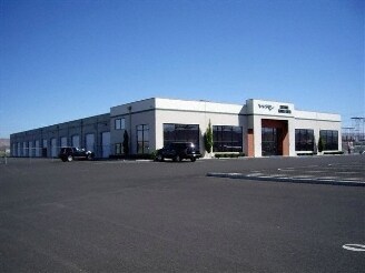
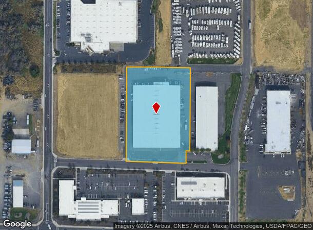
Property Record
1211 W Alder St, Union Gap, WA 98903
NEARBY LISTINGS FOR SALE OR LEASE
Property Detail
1211 W Alder St
Yakima, WA
Binding Site Plan Af# 7857361
191206-24416
SECTION 06 TOWNSHIP 12 RANGE 19 QUARTER NW: BINDING SITE PLAN AF# 7857361: LOT 1-6
Miningfacilityoilgasmineralpreciousmetals
Yakima
X
Washington
53077C1061F
1-6
2025
3.81 AC
2025
Union Gap
001400
Yakima
74,347 SF
DEMOGRAPHICS near 1211 W Alder St
1 Mile
3 Mile
5 Mile
2024 Total Population
3,651
41,966
100,569
2029 Population
3,675
42,010
101,042
Pop Growth 2024-2029
+ 0.66%
+ 0.10%
+ 0.47%
Average Age
37
34
36
2024 Total Households
1,299
13,625
36,221
HH Growth 2024-2029
+ 0.62%
+ 0.02%
+ 0.49%
Median Household Inc
$43,301
$46,296
$51,964
Avg Household Size
2.80
2.90
2.60
2024 Avg HH Vehicles
2.00
2.00
2.00
Median Home Value
$158,193
$171,644
$233,901
Median Year Built
1972
1964
1970
Nearby Places
Map Layers
Map Styles
 Street
 Aerial
- Restaurants
- Banks
- Shops
- Fitness
- Groceries
PUBLIC TRANSPORTATION
AIRPORT
Yakima Air Trml/McAllister Field
DRIVE
WALK
Distance
Yakima Air Trml/McAllister Field
8 min
3.1 mi
Nearby Properties
Address
Land Use
TOTAL SIZE
Lot Size
Zoning
Address
Land Use
TOTAL SIZE
Lot Size
Zoning
390,527 SF
11.86 AC
R3
Address
Land Use
TOTAL SIZE
Lot Size
Zoning
326,323 SF
30.05 AC
R2
Address
Land Use
TOTAL SIZE
Lot Size
Zoning
347,665 SF
37.77 AC
B2
Address
Land Use
TOTAL SIZE
Lot Size
Zoning
208,322 SF
3.69 AC
PUB
Address
Land Use
TOTAL SIZE
Lot Size
Zoning
106,878 SF
3.46 AC
RD
Address
Land Use
TOTAL SIZE
Lot Size
Zoning
82,436 SF
11 AC
RD
Address
Land Use
TOTAL SIZE
Lot Size
Zoning
345,698 SF
3.52 AC
C1
Address
Land Use
TOTAL SIZE
Lot Size
Zoning
100,992 SF
9.15 AC
RD
Address
Land Use
TOTAL SIZE
Lot Size
Zoning
91,856 SF
9.17 AC
RD
Address
Land Use
TOTAL SIZE
Lot Size
Zoning
162,216 SF
11 AC
M1
Address
Land Use
TOTAL SIZE
Lot Size
Zoning
56,505 SF
2.75 AC
C1
Address
Land Use
TOTAL SIZE
Lot Size
Zoning
57,009 SF
212.58 AC
AS
Address
Land Use
TOTAL SIZE
Lot Size
Zoning
64,171 SF
48.08 AC
PUB
Address
Land Use
TOTAL SIZE
Lot Size
Zoning
158,890 SF
13.84 AC
B2
Address
Land Use
TOTAL SIZE
Lot Size
Zoning
197,263 SF
18.08 AC
C1
Address
Land Use
TOTAL SIZE
Lot Size
Zoning
128,789 SF
6.65 AC
R3
Address
Land Use
TOTAL SIZE
Lot Size
Zoning
135,634 SF
9.84 AC
C1
Address
Land Use
TOTAL SIZE
Lot Size
Zoning
97,976 SF
3.98 AC
SCC
Address
Land Use
TOTAL SIZE
Lot Size
Zoning
325,959 SF
11.95 AC
M2
Address
Land Use
TOTAL SIZE
Lot Size
Zoning
80,374 SF
8.99 AC
C1
Address
Land Use
TOTAL SIZE
Lot Size
Zoning
114,406 SF
15.50 AC
PUB
Address
Land Use
TOTAL SIZE
Lot Size
Zoning
94,724 SF
0.79 AC
CBD
Address
Land Use
TOTAL SIZE
Lot Size
Zoning
151,831 SF
21.08 AC
M1
Address
Land Use
TOTAL SIZE
Lot Size
Zoning
43,687 SF
3.33 AC
C1
Address
Land Use
TOTAL SIZE
Lot Size
Zoning
195,753 SF
11.66 AC
M1
Address
Land Use
TOTAL SIZE
Lot Size
Zoning
82,422 SF
4.58 AC
C1
Address
Land Use
TOTAL SIZE
Lot Size
Zoning
38,498 SF
7 AC
C1
Address
Land Use
TOTAL SIZE
Lot Size
Zoning
69.87 AC
SR
Address
Land Use
TOTAL SIZE
Lot Size
Zoning
65,602 SF
10 AC
AS
Address
Land Use
TOTAL SIZE
Lot Size
Zoning
123,690 SF
12.02 AC
M1
The World's #1 Commercial Real Estate Marketplace
Connect with us
© 2025 CoStar Group
The information above has been obtained from sources believed reliable. While we do not doubt its accuracy we have not verified it and make no guarantee, warranty or representation about it. It is your responsibility to independently confirm its accuracy and completeness. Any projections, opinions, assumptions, or estimates used are for example only and do not represent the current or future performance of the property. The value of this transaction to you depends on tax and other factors which should be evaluated by your tax, financial, and legal advisors. You and your advisors should conduct a careful, independent investigation of the property to determine to your satisfaction the suitability of the property for your needs.