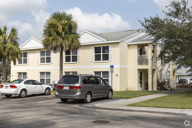
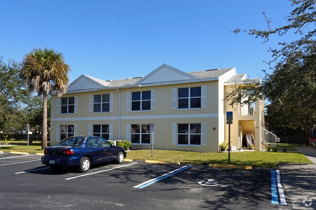
Property Record
121/125 Ne 10Th Pl, Cape Coral, FL 33909
NEARBY LISTINGS FOR SALE OR LEASE
Property Detail
121/125 Ne 10Th Pl
07-44-24-C4-03587.0010
Cape Coral
Orphanage
CAPE CORAL UNIT 46 BLK 3587 PB 17 PG 125 PORTION DESC IN OR 2786 PG 1721
X
Lee
12071C0264G
Florida
2024
5 AC
2025
Hancock
010203
Southwest Florida
55,680 SF
Cape Coral-Fort Myers, FL
DEMOGRAPHICS near 121/125 Ne 10Th Pl
1 Mile
3 Mile
5 Mile
2024 Total Population
8,465
72,861
159,175
2029 Population
9,911
85,913
188,610
Pop Growth 2024-2029
+ 17.08%
+ 17.91%
+ 18.49%
Average Age
42
41
43
2024 Total Households
3,177
27,022
61,153
HH Growth 2024-2029
+ 16.49%
+ 17.30%
+ 17.99%
Median Household Inc
$62,471
$64,331
$64,347
Avg Household Size
2.50
2.60
2.50
2024 Avg HH Vehicles
2.00
2.00
2.00
Median Home Value
$228,110
$253,363
$259,368
Median Year Built
1994
1995
1996
Nearby Places
Map Layers
Map Styles
 Street
 Aerial
- Restaurants
- Banks
- Shops
- Fitness
- Groceries
PUBLIC TRANSPORTATION
AIRPORT
Southwest Florida International
DRIVE
WALK
Distance
Southwest Florida International
36 min
21.4 mi
Punta Gorda
DRIVE
WALK
Distance
Punta Gorda
37 min
23.5 mi
Freight Ports
Port Manatee
DRIVE
WALK
Distance
Port Manatee
117 min
95.2 mi
Nearby Properties
Address
Land Use
TOTAL SIZE
Lot Size
Zoning
Address
Land Use
TOTAL SIZE
Lot Size
Zoning
634,872 SF
43.30 AC
C1-D
Address
Land Use
TOTAL SIZE
Lot Size
Zoning
214,515 SF
30.60 AC
I-1
Address
Land Use
TOTAL SIZE
Lot Size
Zoning
485,271 SF
20.05 AC
CORR
Address
Land Use
TOTAL SIZE
Lot Size
Zoning
476,419 SF
36.49 AC
C1
Address
Land Use
TOTAL SIZE
Lot Size
Zoning
25.99 AC
RML
Address
Land Use
TOTAL SIZE
Lot Size
Zoning
231,454 SF
14.53 AC
CC
Address
Land Use
TOTAL SIZE
Lot Size
Zoning
339,525 SF
38.30 AC
R1BD
Address
Land Use
TOTAL SIZE
Lot Size
Zoning
7.82 AC
CORR
Address
Land Use
TOTAL SIZE
Lot Size
Zoning
333,938 SF
35.80 AC
C-1
Address
Land Use
TOTAL SIZE
Lot Size
Zoning
61,844 SF
7.31 AC
CC
Address
Land Use
TOTAL SIZE
Lot Size
Zoning
138,476 SF
4.11 AC
CORR
Address
Land Use
TOTAL SIZE
Lot Size
Zoning
101,204 SF
12.34 AC
P1-D
Address
Land Use
TOTAL SIZE
Lot Size
Zoning
139,978 SF
10.75 AC
C-1
Address
Land Use
TOTAL SIZE
Lot Size
Zoning
142,773 SF
10.82 AC
C-1
Address
Land Use
TOTAL SIZE
Lot Size
Zoning
101,999 SF
7.17 AC
P-1
Address
Land Use
TOTAL SIZE
Lot Size
Zoning
124,182 SF
13.30 AC
CORR
Address
Land Use
TOTAL SIZE
Lot Size
Zoning
83,035 SF
19.01 AC
CORR
Address
Land Use
TOTAL SIZE
Lot Size
Zoning
124,101 SF
11.60 AC
C-1
Address
Land Use
TOTAL SIZE
Lot Size
Zoning
142,379 SF
3.27 AC
Address
Land Use
TOTAL SIZE
Lot Size
Zoning
76,042 SF
7.50 AC
CORR
Address
Land Use
TOTAL SIZE
Lot Size
Zoning
82,478 SF
15.46 AC
CORR
Address
Land Use
TOTAL SIZE
Lot Size
Zoning
101,110 SF
8.67 AC
VILL
Address
Land Use
TOTAL SIZE
Lot Size
Zoning
212,616 SF
6.61 AC
CORR/CPO
Address
Land Use
TOTAL SIZE
Lot Size
Zoning
78,298 SF
12.73 AC
CORR
Address
Land Use
TOTAL SIZE
Lot Size
Zoning
128,355 SF
19.24 AC
C-1
Address
Land Use
TOTAL SIZE
Lot Size
Zoning
74,678 SF
8.97 AC
CPD
Address
Land Use
TOTAL SIZE
Lot Size
Zoning
227,560 SF
27.45 AC
C1-D
Address
Land Use
TOTAL SIZE
Lot Size
Zoning
92,632 SF
32 AC
R1BD
Address
Land Use
TOTAL SIZE
Lot Size
Zoning
10,377 SF
3.34 AC
RML
Address
Land Use
TOTAL SIZE
Lot Size
Zoning
39,204 SF
5.89 AC
CORR
The World's #1 Commercial Real Estate Marketplace
Connect with us
© 2025 CoStar Group
The information above has been obtained from sources believed reliable. While we do not doubt its accuracy we have not verified it and make no guarantee, warranty or representation about it. It is your responsibility to independently confirm its accuracy and completeness. Any projections, opinions, assumptions, or estimates used are for example only and do not represent the current or future performance of the property. The value of this transaction to you depends on tax and other factors which should be evaluated by your tax, financial, and legal advisors. You and your advisors should conduct a careful, independent investigation of the property to determine to your satisfaction the suitability of the property for your needs.