Property Record
12113 Dessau Rd, Austin, TX 78754
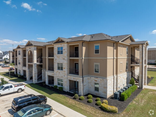

Property Detail
12113 Dessau Rd
Austin-Round Rock-San Marcos, TX
LOT 1,9,10,13-14 BLK A PARMER PARK SUBD AMD PLAT LTS 1-14 BLK A RESUB OF LT 1 BLK A
568900
Travis
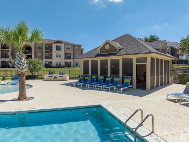
Multifamilydwelling
Texas
B and X Area of moderate flood hazard, usually the area between the limits of the 100-year and 500-year floods.
1
2025
16.85 AC
2025
Parmer Lane
043500
Austin
297,000 SF
NEARBY LISTINGS FOR SALE OR LEASE
-
-
View all Austin listings for sale on LoopNet.com
DEMOGRAPHICS near 12113 Dessau Rd
1 mile
3 mile
5 mile
2025 Total Population
16,735
92,847
262,584
2030 Population
17,634
97,911
275,122
Pop Growth 2025-2030
+ 5.37%
+ 5.45%
+ 4.77%
Average Age
36
36
37
2025 Total Households
6,470
34,298
105,868
HH Growth 2025-2030
+ 6.06%
+ 5.96%
+ 5.33%
Median Household Inc
$81,813
$84,544
$77,013
Avg Household Size
2.50
2.60
2.40
2025 Avg HH Vehicles
2.00
2.00
2.00
Median Home Value
$366,394
$386,533
$406,912
Median Year Built
2007
2003
1997
Nearby Places
Map Layers
Map Styles
 Street
 Aerial
Transit
 Traffic
 Biking
Places
Listings with unknown addresses are not visible on the map
- Restaurants
- Banks
- Shops
- Fitness
- Groceries
PUBLIC TRANSPORTATION
AIRPORT
Austin-Bergstrom International
Drive
Walk
Distance
Austin-Bergstrom International
33 min
19.4 mi
Freight Ports
Calhoun Port
Drive
Walk
Distance
Calhoun Port
194 min
165.8 mi
Nearby Properties
Address
Land Use
TOTAL SIZE
Lot Size
Zoning
Address
Land Use
TOTAL SIZE
Lot Size
Zoning
4,355 SF
263.17 AC
Address
Land Use
TOTAL SIZE
Lot Size
Zoning
368,100 SF
38.07 AC
Address
Land Use
TOTAL SIZE
Lot Size
Zoning
287,272 SF
17.68 AC
Address
Land Use
TOTAL SIZE
Lot Size
Zoning
348,496 SF
17.59 AC
Address
Land Use
TOTAL SIZE
Lot Size
Zoning
398,475 SF
35.14 AC
Address
Land Use
TOTAL SIZE
Lot Size
Zoning
379,500 SF
17.99 AC
Address
Land Use
TOTAL SIZE
Lot Size
Zoning
381,495 SF
13.54 AC
Address
Land Use
TOTAL SIZE
Lot Size
Zoning
6,498 SF
236.84 AC
Address
Land Use
TOTAL SIZE
Lot Size
Zoning
709,789 SF
52.90 AC
Address
Land Use
TOTAL SIZE
Lot Size
Zoning
307,036 SF
21.64 AC
Address
Land Use
TOTAL SIZE
Lot Size
Zoning
459,304 SF
28.36 AC
Address
Land Use
TOTAL SIZE
Lot Size
Zoning
752,804 SF
180.91 AC
Address
Land Use
TOTAL SIZE
Lot Size
Zoning
401,976 SF
38.07 AC
Address
Land Use
TOTAL SIZE
Lot Size
Zoning
311,850 SF
18.09 AC
Address
Land Use
TOTAL SIZE
Lot Size
Zoning
270,780 SF
18.17 AC
Address
Land Use
TOTAL SIZE
Lot Size
Zoning
237,600 SF
14.10 AC
Address
Land Use
TOTAL SIZE
Lot Size
Zoning
323,425 SF
14.20 AC
Address
Land Use
TOTAL SIZE
Lot Size
Zoning
384,776 SF
22.88 AC
Address
Land Use
TOTAL SIZE
Lot Size
Zoning
313,414 SF
37.71 AC
Address
Land Use
TOTAL SIZE
Lot Size
Zoning
264,401 SF
10.48 AC
Address
Land Use
TOTAL SIZE
Lot Size
Zoning
374,432 SF
14.28 AC
Address
Land Use
TOTAL SIZE
Lot Size
Zoning
341,480 SF
16.35 AC
Address
Land Use
TOTAL SIZE
Lot Size
Zoning
439,312 SF
30.08 AC
Address
Land Use
TOTAL SIZE
Lot Size
Zoning
335,856 SF
18.55 AC
Address
Land Use
TOTAL SIZE
Lot Size
Zoning
277,987 SF
11.01 AC
Address
Land Use
TOTAL SIZE
Lot Size
Zoning
272,250 SF
15.31 AC
Address
Land Use
TOTAL SIZE
Lot Size
Zoning
7,260 SF
93.05 AC
Address
Land Use
TOTAL SIZE
Lot Size
Zoning
297,000 SF
16.01 AC
Address
Land Use
TOTAL SIZE
Lot Size
Zoning
242,484 SF
15.50 AC
Address
Land Use
TOTAL SIZE
Lot Size
Zoning
330,841 SF
16.48 AC
The World's #1 Commercial Real Estate Marketplace
Connect with us
© 2026 CoStar Group
The information above has been obtained from sources believed reliable. While we do not doubt its accuracy we have not verified it and make no guarantee, warranty or representation about it. It is your responsibility to independently confirm its accuracy and completeness. Any projections, opinions, assumptions, or estimates used are for example only and do not represent the current or future performance of the property. The value of this transaction to you depends on tax and other factors which should be evaluated by your tax, financial, and legal advisors. You and your advisors should conduct a careful, independent investigation of the property to determine to your satisfaction the suitability of the property for your needs.