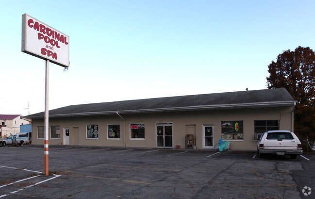
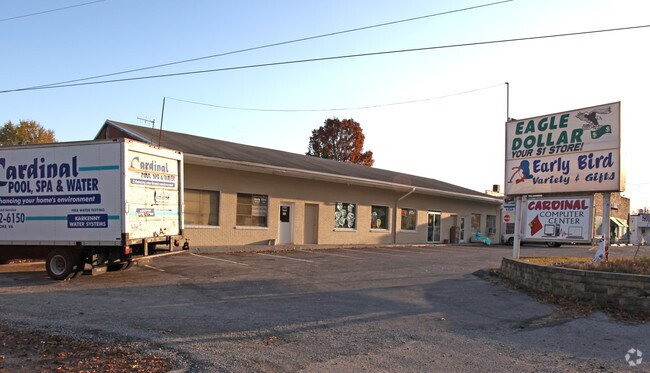
Property Record
1212 Lee Hwy, Roanoke, VA 24019
NEARBY LISTINGS FOR SALE OR LEASE
Property Detail
1212 Lee Hwy
Roanoke, VA
Virgie M Macfarland
106B(2)C
CLOVERDALE
Religious
Botetourt
X
Virginia
51023C0460C
0.75 AC
2024
Botetourt County
2025
Roanoke
040402
DEMOGRAPHICS near 1212 Lee Hwy
1 Mile
3 Mile
5 Mile
2024 Total Population
2,212
16,082
54,186
2029 Population
2,285
16,349
54,431
Pop Growth 2024-2029
+ 3.30%
+ 1.66%
+ 0.45%
Average Age
43
43
43
2024 Total Households
890
6,328
22,408
HH Growth 2024-2029
+ 3.26%
+ 1.63%
+ 0.37%
Median Household Inc
$59,758
$79,240
$67,520
Avg Household Size
2.40
2.40
2.30
2024 Avg HH Vehicles
2.00
2.00
2.00
Median Home Value
$304,687
$273,622
$220,278
Median Year Built
1981
1983
1977
Nearby Places
Map Layers
Map Styles
 Street
 Aerial
- Restaurants
- Banks
- Shops
- Fitness
- Groceries
PUBLIC TRANSPORTATION
COMMUTER RAIL
DRIVE
WALK
Distance
15 min
8.9 mi
AIRPORT
Roanoke/Blacksburg Regional (Woodrum Field)
DRIVE
WALK
Distance
Roanoke/Blacksburg Regional (Woodrum Field)
12 min
5.9 mi
Nearby Properties
Address
Land Use
TOTAL SIZE
Lot Size
Zoning
Address
Land Use
TOTAL SIZE
Lot Size
Zoning
5,957.14 AC
FC
Address
Land Use
TOTAL SIZE
Lot Size
Zoning
4,284 SF
17.86 AC
R3
Address
Land Use
TOTAL SIZE
Lot Size
Zoning
26 AC
R-1
Address
Land Use
TOTAL SIZE
Lot Size
Zoning
9.31 AC
B-1
Address
Land Use
TOTAL SIZE
Lot Size
Zoning
40.12 AC
M-1
Address
Land Use
TOTAL SIZE
Lot Size
Zoning
609,211 SF
41.01 AC
I1C
Address
Land Use
TOTAL SIZE
Lot Size
Zoning
40.04 AC
M-2
Address
Land Use
TOTAL SIZE
Lot Size
Zoning
15,312 SF
182.27 AC
AG3
Address
Land Use
TOTAL SIZE
Lot Size
Zoning
22.52 AC
R-1
Address
Land Use
TOTAL SIZE
Lot Size
Zoning
124,725 SF
6.53 AC
I1
Address
Land Use
TOTAL SIZE
Lot Size
Zoning
36.98 AC
M-1
Address
Land Use
TOTAL SIZE
Lot Size
Zoning
69,212 SF
19.65 AC
R3S
Address
Land Use
TOTAL SIZE
Lot Size
Zoning
70,091 SF
11.82 AC
R1
Address
Land Use
TOTAL SIZE
Lot Size
Zoning
35,582 SF
16.36 AC
I2S
Address
Land Use
TOTAL SIZE
Lot Size
Zoning
35,004 SF
5.07 AC
SCD
Address
Land Use
TOTAL SIZE
Lot Size
Zoning
9.98 AC
A1
Address
Land Use
TOTAL SIZE
Lot Size
Zoning
9.14 AC
M-2
Address
Land Use
TOTAL SIZE
Lot Size
Zoning
58,366 SF
3.02 AC
C2CS
Address
Land Use
TOTAL SIZE
Lot Size
Zoning
14.27 AC
SCD
Address
Land Use
TOTAL SIZE
Lot Size
Zoning
12,252 SF
9.38 AC
R4
Address
Land Use
TOTAL SIZE
Lot Size
Zoning
66,386 SF
8.23 AC
C2CS
Address
Land Use
TOTAL SIZE
Lot Size
Zoning
113,496 SF
6.51 AC
I1
Address
Land Use
TOTAL SIZE
Lot Size
Zoning
28,116 SF
13.48 AC
C2CS
Address
Land Use
TOTAL SIZE
Lot Size
Zoning
35,056 SF
4.03 AC
C2CS
Address
Land Use
TOTAL SIZE
Lot Size
Zoning
4 AC
B-2
Address
Land Use
TOTAL SIZE
Lot Size
Zoning
275,553 SF
23.30 AC
I1
Address
Land Use
TOTAL SIZE
Lot Size
Zoning
67,335 SF
3.97 AC
I1
Address
Land Use
TOTAL SIZE
Lot Size
Zoning
94,216 SF
11.02 AC
I1
Address
Land Use
TOTAL SIZE
Lot Size
Zoning
12.20 AC
4
Address
Land Use
TOTAL SIZE
Lot Size
Zoning
54,312 SF
2.10 AC
C2
The World's #1 Commercial Real Estate Marketplace
Connect with us
© 2025 CoStar Group
The information above has been obtained from sources believed reliable. While we do not doubt its accuracy we have not verified it and make no guarantee, warranty or representation about it. It is your responsibility to independently confirm its accuracy and completeness. Any projections, opinions, assumptions, or estimates used are for example only and do not represent the current or future performance of the property. The value of this transaction to you depends on tax and other factors which should be evaluated by your tax, financial, and legal advisors. You and your advisors should conduct a careful, independent investigation of the property to determine to your satisfaction the suitability of the property for your needs.