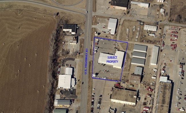
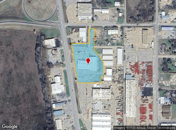
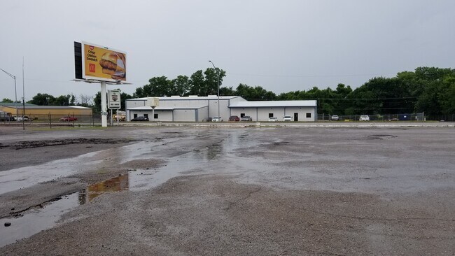
Property Record
1212 S Highway 81, Duncan, OK 73533
Current Lease Availabilities
NEARBY LISTINGS FOR SALE OR LEASE
Property Detail
1212 S Highway 81
Duncan, OK
N/A
1999-07-01S-07W-1-017-00
7-1S-7W TR BEG 1081S & 719.9W NE/C NE S000225W235 S382144E110.7 S425910E19.90 S200052E36.87 S294652E10.42 S895116E10.62 S000846W155.66 S895048W29.50 S000849W69 S895056W266.75 (TO PT ON E R/WY LN HWY 81) N084952W440.12 N895151E202.22 N000113E170 N8951
Storebuilding
Stephens
X
Oklahoma
40137C0355F
7w
2024
3.11 AC
2025
Oklahoma West Area
000600
Other Market Areas
4,000 SF
DEMOGRAPHICS near 1212 S Highway 81
1 Mile
3 Mile
5 Mile
2024 Total Population
3,232
20,612
25,846
2029 Population
3,422
21,546
26,919
Pop Growth 2024-2029
+ 5.88%
+ 4.53%
+ 4.15%
Average Age
40
41
41
2024 Total Households
1,360
8,304
10,519
HH Growth 2024-2029
+ 5.81%
+ 4.40%
+ 4.00%
Median Household Inc
$35,853
$45,975
$50,395
Avg Household Size
2.40
2.40
2.40
2024 Avg HH Vehicles
1.00
2.00
2.00
Median Home Value
$70,599
$111,673
$130,982
Median Year Built
1960
1967
1971
Nearby Places
- Restaurants
- Banks
- Shops
- Fitness
- Groceries
PUBLIC TRANSPORTATION
AIRPORT
Lawton-Fort Sill Regional
DRIVE
WALK
Distance
Lawton-Fort Sill Regional
49 min
37.1 mi
Freight Ports
Tulsa Port Of Catoosa
DRIVE
WALK
Distance
Tulsa Port Of Catoosa
227 min
204.6 mi
Nearby Properties
Address
Land Use
TOTAL SIZE
Lot Size
Zoning
Address
Land Use
TOTAL SIZE
Lot Size
Zoning
91,737 SF
40 AC
C1
Address
Land Use
TOTAL SIZE
Lot Size
Zoning
4,064 SF
43.23 AC
Address
Land Use
TOTAL SIZE
Lot Size
Zoning
127,660 SF
20 AC
Address
Land Use
TOTAL SIZE
Lot Size
Zoning
63,093 SF
23.46 AC
Address
Land Use
TOTAL SIZE
Lot Size
Zoning
34,192 SF
80.31 AC
Address
Land Use
TOTAL SIZE
Lot Size
Zoning
9,694 SF
5.12 AC
C2
Address
Land Use
TOTAL SIZE
Lot Size
Zoning
825 SF
97.38 AC
Address
Land Use
TOTAL SIZE
Lot Size
Zoning
28,987 SF
20 AC
R1
Address
Land Use
TOTAL SIZE
Lot Size
Zoning
82,956 SF
11.54 AC
C1
Address
Land Use
TOTAL SIZE
Lot Size
Zoning
86,400 SF
5 AC
C1
Address
Land Use
TOTAL SIZE
Lot Size
Zoning
2,460 SF
123.87 AC
Address
Land Use
TOTAL SIZE
Lot Size
Zoning
2,500 SF
77.76 AC
C1
Address
Land Use
TOTAL SIZE
Lot Size
Zoning
32,998 SF
2.64 AC
C2
Address
Land Use
TOTAL SIZE
Lot Size
Zoning
260 SF
1.93 AC
R1
Address
Land Use
TOTAL SIZE
Lot Size
Zoning
816 SF
8 AC
C2
Address
Land Use
TOTAL SIZE
Lot Size
Zoning
7,478 SF
1.26 AC
R1
Address
Land Use
TOTAL SIZE
Lot Size
Zoning
30,841 SF
3.12 AC
R1
Address
Land Use
TOTAL SIZE
Lot Size
Zoning
17,205 SF
160 AC
C2
Address
Land Use
TOTAL SIZE
Lot Size
Zoning
25,732 SF
20 AC
C1
Address
Land Use
TOTAL SIZE
Lot Size
Zoning
1,440 SF
33.58 AC
Address
Land Use
TOTAL SIZE
Lot Size
Zoning
9,014 SF
1.77 AC
C1
Address
Land Use
TOTAL SIZE
Lot Size
Zoning
61,514 SF
2.34 AC
C1
Address
Land Use
TOTAL SIZE
Lot Size
Zoning
170 SF
4.88 AC
Address
Land Use
TOTAL SIZE
Lot Size
Zoning
18,492 SF
9.89 AC
C1
Address
Land Use
TOTAL SIZE
Lot Size
Zoning
20,966 SF
5 AC
R1
Address
Land Use
TOTAL SIZE
Lot Size
Zoning
2,632 SF
120 AC
R1
Address
Land Use
TOTAL SIZE
Lot Size
Zoning
2,400 SF
2.75 AC
R1
Address
Land Use
TOTAL SIZE
Lot Size
Zoning
900 SF
1.74 AC
C2
Address
Land Use
TOTAL SIZE
Lot Size
Zoning
38,723 SF
5.62 AC
R1
Address
Land Use
TOTAL SIZE
Lot Size
Zoning
13,770 SF
3.55 AC
R1
The World's #1 Commercial Real Estate Marketplace
Connect with us
© 2025 CoStar Group
The information above has been obtained from sources believed reliable. While we do not doubt its accuracy we have not verified it and make no guarantee, warranty or representation about it. It is your responsibility to independently confirm its accuracy and completeness. Any projections, opinions, assumptions, or estimates used are for example only and do not represent the current or future performance of the property. The value of this transaction to you depends on tax and other factors which should be evaluated by your tax, financial, and legal advisors. You and your advisors should conduct a careful, independent investigation of the property to determine to your satisfaction the suitability of the property for your needs.