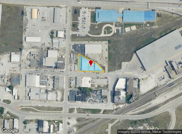
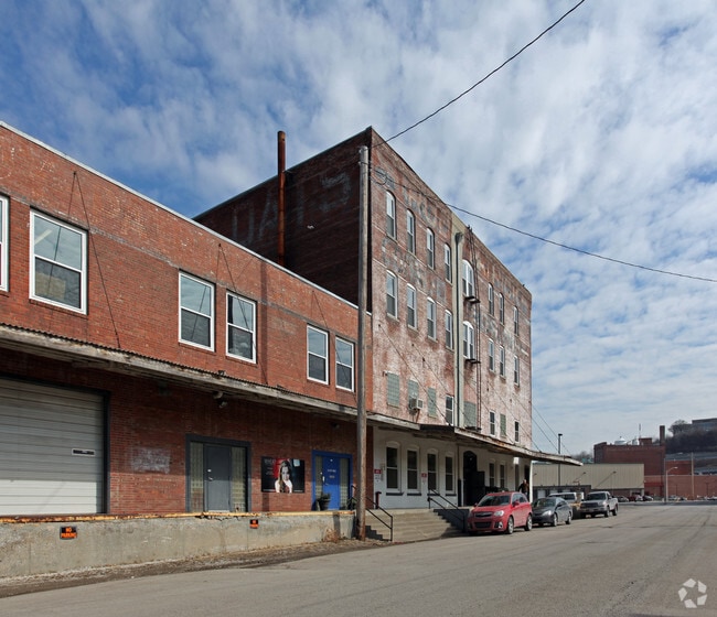
Property Record
1212 W 8Th St, Kansas City, MO 64101

NEARBY LISTINGS FOR SALE OR LEASE
Property Detail
1212 W 8Th St
Kansas City, MO-KS
West Kansas Add No 1
29-320-13-12-00-0-00-000
WEST KANSAS ADD #1 TH PT LOTS 4-7 & PT LO TS 20 THRU 30 BLK 15 & INCL VAC ALLEYSADJ TO SD LOTS, ALL LY S OFSTL & S F RR ROW.
Warehouse
Jackson
AH
Missouri
29095C0251G
4-7
2024
0.53 AC
2025
Downtown KC
015200
Kansas City
45,171 SF
DEMOGRAPHICS near 1212 W 8Th St
1 Mile
3 Mile
5 Mile
2024 Total Population
10,157
84,446
247,513
2029 Population
10,392
85,505
250,850
Pop Growth 2024-2029
+ 2.31%
+ 1.25%
+ 1.35%
Average Age
35
35
36
2024 Total Households
6,851
37,996
107,013
HH Growth 2024-2029
+ 2.23%
+ 1.77%
+ 1.58%
Median Household Inc
$64,814
$51,147
$50,472
Avg Household Size
1.40
2.00
2.20
2024 Avg HH Vehicles
1.00
1.00
1.00
Median Home Value
$255,555
$166,422
$149,795
Median Year Built
1961
1957
1954
Nearby Places
- Restaurants
- Banks
- Shops
- Fitness
- Groceries
PUBLIC TRANSPORTATION
COMMUTER RAIL
DRIVE
WALK
Distance
8 min
2.8 mi
AIRPORT
Kansas City International
DRIVE
WALK
Distance
Kansas City International
28 min
19.4 mi
SALE & LEASE HISTORY
LISTING DATE
SALE/LEASE

Mar 14, 2022
For Sale
Nearby Properties
Address
Land Use
TOTAL SIZE
Lot Size
Zoning
Address
Land Use
TOTAL SIZE
Lot Size
Zoning
172,810 SF
Address
Land Use
TOTAL SIZE
Lot Size
Zoning
568,235 SF
9.59 AC
Address
Land Use
TOTAL SIZE
Lot Size
Zoning
126,962 SF
4.50 AC
KC0
Address
Land Use
TOTAL SIZE
Lot Size
Zoning
488,351 SF
8.34 AC
Address
Land Use
TOTAL SIZE
Lot Size
Zoning
132,304 SF
3.72 AC
KCD
Address
Land Use
TOTAL SIZE
Lot Size
Zoning
1,825,083 SF
25.77 AC
Address
Land Use
TOTAL SIZE
Lot Size
Zoning
63,748 SF
3.92 AC
Address
Land Use
TOTAL SIZE
Lot Size
Zoning
404,524 SF
5.51 AC
Address
Land Use
TOTAL SIZE
Lot Size
Zoning
711,196 SF
15.58 AC
Address
Land Use
TOTAL SIZE
Lot Size
Zoning
277,042 SF
0.40 AC
Address
Land Use
TOTAL SIZE
Lot Size
Zoning
257,647 SF
3.63 AC
Address
Land Use
TOTAL SIZE
Lot Size
Zoning
277,267 SF
4.18 AC
KCD
Address
Land Use
TOTAL SIZE
Lot Size
Zoning
44,491 SF
1.96 AC
C3A2
Address
Land Use
TOTAL SIZE
Lot Size
Zoning
81,578 SF
1.63 AC
Address
Land Use
TOTAL SIZE
Lot Size
Zoning
115,627 SF
1.56 AC
Address
Land Use
TOTAL SIZE
Lot Size
Zoning
261,570 SF
1.82 AC
Address
Land Use
TOTAL SIZE
Lot Size
Zoning
162,989 SF
3.92 AC
KC0
Address
Land Use
TOTAL SIZE
Lot Size
Zoning
157,488 SF
1.60 AC
Address
Land Use
TOTAL SIZE
Lot Size
Zoning
87,294 SF
0.70 AC
Address
Land Use
TOTAL SIZE
Lot Size
Zoning
803,812 SF
5.85 AC
Address
Land Use
TOTAL SIZE
Lot Size
Zoning
384,543 SF
5.40 AC
Address
Land Use
TOTAL SIZE
Lot Size
Zoning
274,622 SF
1.35 AC
Address
Land Use
TOTAL SIZE
Lot Size
Zoning
342,989 SF
1.84 AC
Address
Land Use
TOTAL SIZE
Lot Size
Zoning
93,870 SF
3.31 AC
KC0
Address
Land Use
TOTAL SIZE
Lot Size
Zoning
4,012,734 SF
574.30 AC
KM3
Address
Land Use
TOTAL SIZE
Lot Size
Zoning
238,003 SF
1.74 AC
Address
Land Use
TOTAL SIZE
Lot Size
Zoning
349,977 SF
2.21 AC
Address
Land Use
TOTAL SIZE
Lot Size
Zoning
191,753 SF
0.79 AC
M1
Address
Land Use
TOTAL SIZE
Lot Size
Zoning
27,292 SF
10.75 AC
Address
Land Use
TOTAL SIZE
Lot Size
Zoning
250,410 SF
3.74 AC
The World's #1 Commercial Real Estate Marketplace
Connect with us
© 2025 CoStar Group
The information above has been obtained from sources believed reliable. While we do not doubt its accuracy we have not verified it and make no guarantee, warranty or representation about it. It is your responsibility to independently confirm its accuracy and completeness. Any projections, opinions, assumptions, or estimates used are for example only and do not represent the current or future performance of the property. The value of this transaction to you depends on tax and other factors which should be evaluated by your tax, financial, and legal advisors. You and your advisors should conduct a careful, independent investigation of the property to determine to your satisfaction the suitability of the property for your needs.