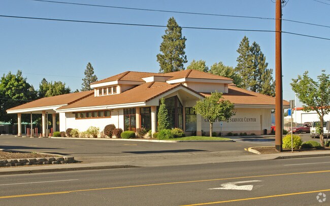
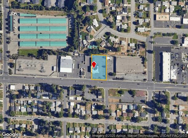
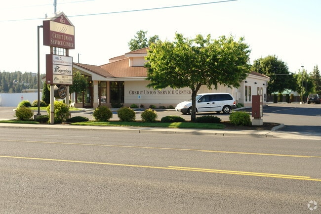
Property Record
1212 W Francis Ave, Spokane, WA 99205

NEARBY LISTINGS FOR SALE OR LEASE
Property Detail
1212 W Francis Ave
36303.9033
PORTION OF GOVT LOT 4
Financialbuilding
Spokane
X
Washington
53063C0533D
4
2025
0.62 AC
2025
NW North Metro
011000
Spokane
3,744 SF
Spokane-Spokane Valley, WA
DEMOGRAPHICS near 1212 W Francis Ave
1 Mile
3 Mile
5 Mile
2024 Total Population
14,728
121,649
206,648
2029 Population
15,570
129,091
219,633
Pop Growth 2024-2029
+ 5.72%
+ 6.12%
+ 6.28%
Average Age
39
39
39
2024 Total Households
6,025
48,421
84,217
HH Growth 2024-2029
+ 5.86%
+ 6.28%
+ 6.59%
Median Household Inc
$62,204
$58,635
$56,648
Avg Household Size
2.40
2.40
2.30
2024 Avg HH Vehicles
2.00
2.00
2.00
Median Home Value
$275,675
$281,486
$295,596
Median Year Built
1955
1959
1966
Nearby Places
Map Layers
Map Styles
 Street
 Aerial
- Restaurants
- Banks
- Shops
- Fitness
- Groceries
PUBLIC TRANSPORTATION
COMMUTER RAIL
DRIVE
WALK
Distance
13 min
4.8 mi
AIRPORT
Spokane International
DRIVE
WALK
Distance
Spokane International
21 min
10.1 mi
Nearby Properties
Address
Land Use
TOTAL SIZE
Lot Size
Zoning
Address
Land Use
TOTAL SIZE
Lot Size
Zoning
545,909 SF
92.96 AC
LDR
Address
Land Use
TOTAL SIZE
Lot Size
Zoning
531,295 SF
17.11 AC
CC2
Address
Land Use
TOTAL SIZE
Lot Size
Zoning
171,479 SF
67.30 AC
RSF
Address
Land Use
TOTAL SIZE
Lot Size
Zoning
386,885 SF
22.81 AC
RSF
Address
Land Use
TOTAL SIZE
Lot Size
Zoning
310,606 SF
27.56 AC
RMF
Address
Land Use
TOTAL SIZE
Lot Size
Zoning
278,777 SF
5.47 AC
HDR
Address
Land Use
TOTAL SIZE
Lot Size
Zoning
180,822 SF
16.11 AC
CC1
Address
Land Use
TOTAL SIZE
Lot Size
Zoning
188,040 SF
68.10 AC
UR
Address
Land Use
TOTAL SIZE
Lot Size
Zoning
139,485 SF
16.74 AC
RSF
Address
Land Use
TOTAL SIZE
Lot Size
Zoning
456,984 SF
26.06 AC
O
Address
Land Use
TOTAL SIZE
Lot Size
Zoning
317,750 SF
31.10 AC
GC
Address
Land Use
TOTAL SIZE
Lot Size
Zoning
1,555,116 SF
23.12 AC
GC
Address
Land Use
TOTAL SIZE
Lot Size
Zoning
228,981 SF
5.32 AC
RHD
Address
Land Use
TOTAL SIZE
Lot Size
Zoning
56,600 SF
4.98 AC
GC
Address
Land Use
TOTAL SIZE
Lot Size
Zoning
159,508 SF
18.52 AC
RSF
Address
Land Use
TOTAL SIZE
Lot Size
Zoning
158,348 SF
6.60 AC
RMF
Address
Land Use
TOTAL SIZE
Lot Size
Zoning
136,780 SF
8.75 AC
RMF
Address
Land Use
TOTAL SIZE
Lot Size
Zoning
101,372 SF
5.48 AC
RMF
Address
Land Use
TOTAL SIZE
Lot Size
Zoning
76,559 SF
7.11 AC
LDR
Address
Land Use
TOTAL SIZE
Lot Size
Zoning
131,469 SF
7.24 AC
RMF
Address
Land Use
TOTAL SIZE
Lot Size
Zoning
150,061 SF
5.01 AC
GC
Address
Land Use
TOTAL SIZE
Lot Size
Zoning
153,780 SF
10.31 AC
RMF
Address
Land Use
TOTAL SIZE
Lot Size
Zoning
95,030 SF
3.51 AC
CC1
Address
Land Use
TOTAL SIZE
Lot Size
Zoning
67,094 SF
9.33 AC
RSF
Address
Land Use
TOTAL SIZE
Lot Size
Zoning
108 AC
RSF
Address
Land Use
TOTAL SIZE
Lot Size
Zoning
160,810 SF
25.18 AC
RMF
Address
Land Use
TOTAL SIZE
Lot Size
Zoning
99,984 SF
4.45 AC
O
Address
Land Use
TOTAL SIZE
Lot Size
Zoning
113,638 SF
34.05 AC
RSF
Address
Land Use
TOTAL SIZE
Lot Size
Zoning
114,377 SF
2.51 AC
RSF
Address
Land Use
TOTAL SIZE
Lot Size
Zoning
230,295 SF
22.41 AC
GC
The World's #1 Commercial Real Estate Marketplace
Connect with us
© 2025 CoStar Group
The information above has been obtained from sources believed reliable. While we do not doubt its accuracy we have not verified it and make no guarantee, warranty or representation about it. It is your responsibility to independently confirm its accuracy and completeness. Any projections, opinions, assumptions, or estimates used are for example only and do not represent the current or future performance of the property. The value of this transaction to you depends on tax and other factors which should be evaluated by your tax, financial, and legal advisors. You and your advisors should conduct a careful, independent investigation of the property to determine to your satisfaction the suitability of the property for your needs.