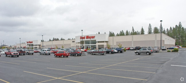
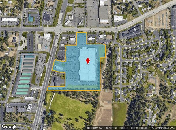
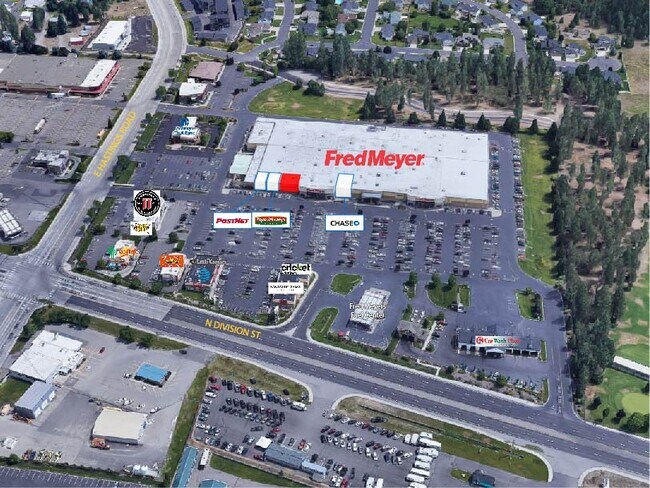
Property Record
12120 N Division St, Spokane, WA 99218
NEARBY LISTINGS FOR SALE OR LEASE
Property Detail
12120 N Division St
36082.9193
BSP 97-58 1ST AMENDMENT (AFN# 5378152) PARCEL G OF RECORDED SURVEY AUDITORS #5549210 BK 127 PG 77
Storebuilding
Spokane
X
Washington
53063C0369D
15.18 AC
2025
NE North Metro
2025
Spokane
010505
Spokane-Spokane Valley, WA
165,954 SF
DEMOGRAPHICS near 12120 N Division St
1 Mile
3 Mile
5 Mile
2024 Total Population
9,272
45,410
122,677
2029 Population
9,780
48,156
130,064
Pop Growth 2024-2029
+ 5.48%
+ 6.05%
+ 6.02%
Average Age
42
39
40
2024 Total Households
3,515
17,053
47,242
HH Growth 2024-2029
+ 5.52%
+ 6.23%
+ 6.19%
Median Household Inc
$76,921
$72,833
$66,710
Avg Household Size
2.50
2.50
2.50
2024 Avg HH Vehicles
2.00
2.00
2.00
Median Home Value
$408,623
$385,270
$347,908
Median Year Built
1990
1988
1978
Nearby Places
Map Layers
Map Styles
 Street
 Aerial
- Restaurants
- Banks
- Shops
- Fitness
- Groceries
PUBLIC TRANSPORTATION
COMMUTER RAIL
DRIVE
WALK
Distance
19 min
8.0 mi
AIRPORT
Spokane International
DRIVE
WALK
Distance
Spokane International
29 min
14.4 mi
SALE & LEASE HISTORY
LISTING DATE
SALE/LEASE

Apr 08, 2020
For Lease
Nearby Properties
Address
Land Use
TOTAL SIZE
Lot Size
Zoning
Address
Land Use
TOTAL SIZE
Lot Size
Zoning
545,909 SF
92.96 AC
LDR
Address
Land Use
TOTAL SIZE
Lot Size
Zoning
278,777 SF
5.47 AC
HDR
Address
Land Use
TOTAL SIZE
Lot Size
Zoning
188,040 SF
68.10 AC
UR
Address
Land Use
TOTAL SIZE
Lot Size
Zoning
456,984 SF
26.06 AC
O
Address
Land Use
TOTAL SIZE
Lot Size
Zoning
317,750 SF
31.10 AC
GC
Address
Land Use
TOTAL SIZE
Lot Size
Zoning
78,497 SF
9.19 AC
MU
Address
Land Use
TOTAL SIZE
Lot Size
Zoning
215,573 SF
11.30 AC
HDR
Address
Land Use
TOTAL SIZE
Lot Size
Zoning
172,525 SF
8.18 AC
HDR
Address
Land Use
TOTAL SIZE
Lot Size
Zoning
116,772 SF
8.56 AC
MU
Address
Land Use
TOTAL SIZE
Lot Size
Zoning
166,390 SF
19.33 AC
MU
Address
Land Use
TOTAL SIZE
Lot Size
Zoning
136,780 SF
8.75 AC
RMF
Address
Land Use
TOTAL SIZE
Lot Size
Zoning
131,469 SF
7.24 AC
RMF
Address
Land Use
TOTAL SIZE
Lot Size
Zoning
150,061 SF
5.01 AC
GC
Address
Land Use
TOTAL SIZE
Lot Size
Zoning
153,780 SF
10.31 AC
RMF
Address
Land Use
TOTAL SIZE
Lot Size
Zoning
67,094 SF
9.33 AC
RSF
Address
Land Use
TOTAL SIZE
Lot Size
Zoning
209,047 SF
41.68 AC
HI
Address
Land Use
TOTAL SIZE
Lot Size
Zoning
121,519 SF
6.26 AC
HDR
Address
Land Use
TOTAL SIZE
Lot Size
Zoning
64,558 SF
11.91 AC
LDR
Address
Land Use
TOTAL SIZE
Lot Size
Zoning
183,152 SF
38.47 AC
LDR
Address
Land Use
TOTAL SIZE
Lot Size
Zoning
230,295 SF
22.41 AC
GC
Address
Land Use
TOTAL SIZE
Lot Size
Zoning
35,343 SF
5.31 AC
GC
Address
Land Use
TOTAL SIZE
Lot Size
Zoning
183,704 SF
12.67 AC
RMF
Address
Land Use
TOTAL SIZE
Lot Size
Zoning
179,208 SF
13.94 AC
RMF
Address
Land Use
TOTAL SIZE
Lot Size
Zoning
142,448 SF
14.85 AC
RMF
Address
Land Use
TOTAL SIZE
Lot Size
Zoning
317,432 SF
36.25 AC
LDR
Address
Land Use
TOTAL SIZE
Lot Size
Zoning
156,212 SF
11.31 AC
MU
Address
Land Use
TOTAL SIZE
Lot Size
Zoning
107,246 SF
6.63 AC
GC
Address
Land Use
TOTAL SIZE
Lot Size
Zoning
68,197 SF
5.16 AC
RSF
Address
Land Use
TOTAL SIZE
Lot Size
Zoning
105,791 SF
22.82 AC
LDR
The World's #1 Commercial Real Estate Marketplace
Connect with us
© 2026 CoStar Group
The information above has been obtained from sources believed reliable. While we do not doubt its accuracy we have not verified it and make no guarantee, warranty or representation about it. It is your responsibility to independently confirm its accuracy and completeness. Any projections, opinions, assumptions, or estimates used are for example only and do not represent the current or future performance of the property. The value of this transaction to you depends on tax and other factors which should be evaluated by your tax, financial, and legal advisors. You and your advisors should conduct a careful, independent investigation of the property to determine to your satisfaction the suitability of the property for your needs.