Property Record
12122 Cherry Tree Crossing Rd, Brandywine, MD 20613

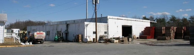
Property Detail
12122 Cherry Tree Crossing Rd
11-1136829
PRINCE GEORGE'S
Industrialgeneral
Maryland
IE
4.09 AC
B and X Area of moderate flood hazard, usually the area between the limits of the 100-year and 500-year floods.
Brandywine/PG South
2024
Washington, DC
2025
Washington-Arlington-Alexandria, DC-VA-MD-WV
801003
NEARBY LISTINGS FOR SALE OR LEASE
-
-
View all Brandywine listings for sale on LoopNet.com
DEMOGRAPHICS near 12122 Cherry Tree Crossing Rd
1 mile
3 mile
5 mile
2025 Total Population
1,142
17,455
63,234
2030 Population
1,194
17,947
64,599
Pop Growth 2025-2030
+ 4.55%
+ 2.82%
+ 2.16%
Average Age
41
43
43
2025 Total Households
381
5,927
21,967
HH Growth 2025-2030
+ 4.72%
+ 3.07%
+ 2.28%
Median Household Inc
$152,397
$147,192
$130,803
Avg Household Size
2.90
2.90
2.80
2025 Avg HH Vehicles
2.00
3.00
2.00
Median Home Value
$623,272
$485,582
$459,091
Median Year Built
2002
1995
1991
Nearby Places
Map Layers
Map Styles
 Street
 Aerial
Transit
 Traffic
 Biking
Places
Listings with unknown addresses are not visible on the map
- Restaurants
- Banks
- Shops
- Fitness
- Groceries
PUBLIC TRANSPORTATION
AIRPORT
Ronald Reagan Washington Ntl
Drive
Walk
Distance
Ronald Reagan Washington Ntl
42 min
24.3 mi
Freight Ports
Port of Baltimore
Drive
Walk
Distance
Port of Baltimore
68 min
45.6 mi
Nearby Properties
Address
Land Use
TOTAL SIZE
Lot Size
Zoning
Address
Land Use
TOTAL SIZE
Lot Size
Zoning
801,684 SF
34.05 AC
IE
Address
Land Use
TOTAL SIZE
Lot Size
Zoning
7,000 SF
354.62 AC
ROS
Address
Land Use
TOTAL SIZE
Lot Size
Zoning
341,372 SF
14.74 AC
RR
Address
Land Use
TOTAL SIZE
Lot Size
Zoning
388,608 SF
28.45 AC
LCD
Address
Land Use
TOTAL SIZE
Lot Size
Zoning
76,906 SF
168.92 AC
AG
Address
Land Use
TOTAL SIZE
Lot Size
Zoning
126,592 SF
58.79 AC
ROS
Address
Land Use
TOTAL SIZE
Lot Size
Zoning
939.06 AC
RR
Address
Land Use
TOTAL SIZE
Lot Size
Zoning
61,836 SF
9.63 AC
IE
Address
Land Use
TOTAL SIZE
Lot Size
Zoning
2.49 AC
CGO
Address
Land Use
TOTAL SIZE
Lot Size
Zoning
48,146 SF
4.48 AC
RR
Address
Land Use
TOTAL SIZE
Lot Size
Zoning
87 AC
IH
Address
Land Use
TOTAL SIZE
Lot Size
Zoning
137,226 SF
25.66 AC
RR
Address
Land Use
TOTAL SIZE
Lot Size
Zoning
44,710 SF
10.05 AC
ROS
Address
Land Use
TOTAL SIZE
Lot Size
Zoning
24,570 SF
39.87 AC
IE
Address
Land Use
TOTAL SIZE
Lot Size
Zoning
21,720 SF
10 AC
RR
Address
Land Use
TOTAL SIZE
Lot Size
Zoning
76,336 SF
5.93 AC
CGO
Address
Land Use
TOTAL SIZE
Lot Size
Zoning
25.21 AC
IE
Address
Land Use
TOTAL SIZE
Lot Size
Zoning
81,602 SF
28.57 AC
IH
Address
Land Use
TOTAL SIZE
Lot Size
Zoning
6,908 SF
3.34 AC
CS
Address
Land Use
TOTAL SIZE
Lot Size
Zoning
14,763 SF
1.96 AC
CS
Address
Land Use
TOTAL SIZE
Lot Size
Zoning
1,986 SF
47.96 AC
IH
Address
Land Use
TOTAL SIZE
Lot Size
Zoning
87,874 SF
14.71 AC
RR
Address
Land Use
TOTAL SIZE
Lot Size
Zoning
1,496 SF
1.72 AC
TACE
Address
Land Use
TOTAL SIZE
Lot Size
Zoning
20,858 SF
5.12 AC
RR
Address
Land Use
TOTAL SIZE
Lot Size
Zoning
18,000 SF
26.68 AC
RR
Address
Land Use
TOTAL SIZE
Lot Size
Zoning
137.39 AC
LCD
Address
Land Use
TOTAL SIZE
Lot Size
Zoning
28,855 SF
10.19 AC
RR
Address
Land Use
TOTAL SIZE
Lot Size
Zoning
15,100 SF
8.82 AC
AR
Address
Land Use
TOTAL SIZE
Lot Size
Zoning
403.77 AC
ROS
Address
Land Use
TOTAL SIZE
Lot Size
Zoning
46,887 SF
24.53 AC
AR
The World's #1 Commercial Real Estate Marketplace
Connect with us
© 2026 CoStar Group
The information above has been obtained from sources believed reliable. While we do not doubt its accuracy we have not verified it and make no guarantee, warranty or representation about it. It is your responsibility to independently confirm its accuracy and completeness. Any projections, opinions, assumptions, or estimates used are for example only and do not represent the current or future performance of the property. The value of this transaction to you depends on tax and other factors which should be evaluated by your tax, financial, and legal advisors. You and your advisors should conduct a careful, independent investigation of the property to determine to your satisfaction the suitability of the property for your needs.