Property Record
12125 Key Peninsula Hwy Nw, Gig Harbor, WA 98329

NEARBY LISTINGS FOR SALE OR LEASE
-
-
View all Gig Harbor listings for sale on LoopNet.com
Property Detail
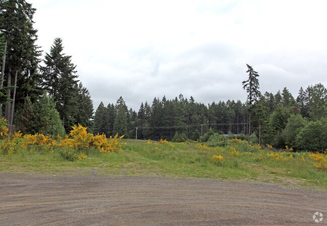
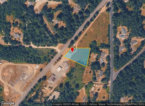
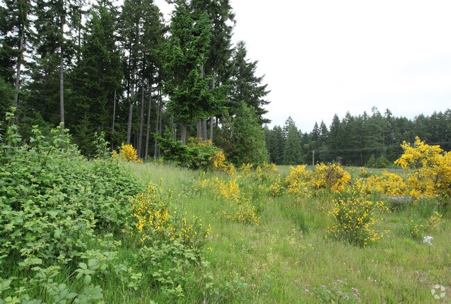
12125 Key Peninsula Hwy Nw
Seattle-Tacoma-Bellevue, WA
Short Plat 200910215001
012230-5027
SECTION 30 TOWNSHIP 22 RANGE 01 QUARTER 14 L 1 OF S P 2009-10-21-5001 AN ALTER OF S P 89-09-26-0262 EXC POR CYD TO P CO PER ETN 4265670 TOG/W EASE & RESTRIC OF REC OUT OF 5-021 SEG A0153 SG HW DC11/12/09JU DC00246909 4/27/12 KG
Commercialacreage
Pierce
X
Washington
53053C0125E
1
2024
0.92 AC
2025
Gig Harbor/W Pierce Co
072602
Seattle/Puget Sound
DEMOGRAPHICS near 12125 Key Peninsula Hwy Nw
1 Mile
3 Mile
5 Mile
2024 Total Population
1,920
8,679
25,255
2029 Population
1,972
8,894
25,849
Pop Growth 2024-2029
+ 2.71%
+ 2.48%
+ 2.35%
Average Age
42
43
43
2024 Total Households
722
3,268
9,109
HH Growth 2024-2029
+ 2.63%
+ 2.48%
+ 2.40%
Median Household Inc
$113,908
$113,532
$114,499
Avg Household Size
2.60
2.60
2.60
2024 Avg HH Vehicles
3.00
3.00
3.00
Median Home Value
$481,981
$499,157
$603,710
Median Year Built
1990
1991
1989
Nearby Places
Map Layers
Map Styles
 Street
 Aerial
- Restaurants
- Banks
- Shops
- Fitness
- Groceries
PUBLIC TRANSPORTATION
AIRPORT
Seattle-Tacoma International
DRIVE
WALK
Distance
Seattle-Tacoma International
63 min
42.3 mi
Freight Ports
Port of Tacoma
DRIVE
WALK
Distance
Port of Tacoma
35 min
23.9 mi
Nearby Properties
Address
Land Use
TOTAL SIZE
Lot Size
Zoning
Address
Land Use
TOTAL SIZE
Lot Size
Zoning
58,516 SF
4.82 AC
R10
Address
Land Use
TOTAL SIZE
Lot Size
Zoning
34,375 SF
105.71 AC
PR
Address
Land Use
TOTAL SIZE
Lot Size
Zoning
21,939 SF
5 AC
RAC
Address
Land Use
TOTAL SIZE
Lot Size
Zoning
15,476 SF
2.77 AC
RNC
Address
Land Use
TOTAL SIZE
Lot Size
Zoning
23,610 SF
2.75 AC
RAC
Address
Land Use
TOTAL SIZE
Lot Size
Zoning
42,971 SF
10.01 AC
R10
Address
Land Use
TOTAL SIZE
Lot Size
Zoning
19,755 SF
0.82 AC
RAC
Address
Land Use
TOTAL SIZE
Lot Size
Zoning
18,650 SF
2.20 AC
RAC
Address
Land Use
TOTAL SIZE
Lot Size
Zoning
11,719 SF
4.32 AC
R10
Address
Land Use
TOTAL SIZE
Lot Size
Zoning
8,790 SF
1.34 AC
RNC
Address
Land Use
TOTAL SIZE
Lot Size
Zoning
7,162 SF
1.02 AC
RAC
Address
Land Use
TOTAL SIZE
Lot Size
Zoning
Address
Land Use
TOTAL SIZE
Lot Size
Zoning
3,978 SF
1.48 AC
RAC
Address
Land Use
TOTAL SIZE
Lot Size
Zoning
7,497 SF
16.79 AC
ARL
Address
Land Use
TOTAL SIZE
Lot Size
Zoning
5,054 SF
2.62 AC
R10
Address
Land Use
TOTAL SIZE
Lot Size
Zoning
13,072 SF
52.70 AC
Address
Land Use
TOTAL SIZE
Lot Size
Zoning
3,456 SF
5.42 AC
RNC
Address
Land Use
TOTAL SIZE
Lot Size
Zoning
7,180 SF
20 AC
RSR
Address
Land Use
TOTAL SIZE
Lot Size
Zoning
2.20 AC
R10
Address
Land Use
TOTAL SIZE
Lot Size
Zoning
9.83 AC
RAC
Address
Land Use
TOTAL SIZE
Lot Size
Zoning
5,232 SF
14.22 AC
R10
Address
Land Use
TOTAL SIZE
Lot Size
Zoning
3,968 SF
0.51 AC
RNC
Address
Land Use
TOTAL SIZE
Lot Size
Zoning
23,292 SF
10.06 AC
R10
Address
Land Use
TOTAL SIZE
Lot Size
Zoning
5,018 SF
8.02 AC
RAC
Address
Land Use
TOTAL SIZE
Lot Size
Zoning
616 SF
6.16 AC
R10
Address
Land Use
TOTAL SIZE
Lot Size
Zoning
7,136 SF
19.66 AC
RF
Address
Land Use
TOTAL SIZE
Lot Size
Zoning
614 SF
18.60 AC
R10
Address
Land Use
TOTAL SIZE
Lot Size
Zoning
1.32 AC
R10
Address
Land Use
TOTAL SIZE
Lot Size
Zoning
160 AC
PR
Address
Land Use
TOTAL SIZE
Lot Size
Zoning
6,450 SF
1.75 AC
RAC
The World's #1 Commercial Real Estate Marketplace
Connect with us
© 2025 CoStar Group
The information above has been obtained from sources believed reliable. While we do not doubt its accuracy we have not verified it and make no guarantee, warranty or representation about it. It is your responsibility to independently confirm its accuracy and completeness. Any projections, opinions, assumptions, or estimates used are for example only and do not represent the current or future performance of the property. The value of this transaction to you depends on tax and other factors which should be evaluated by your tax, financial, and legal advisors. You and your advisors should conduct a careful, independent investigation of the property to determine to your satisfaction the suitability of the property for your needs.