Property Record
1213 Sparrow Ln, Peekskill, NY 10566
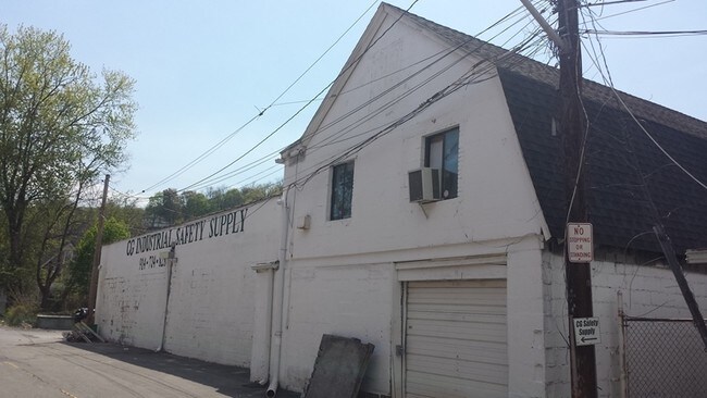
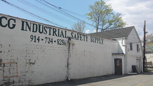
Property Detail
1213 Sparrow Ln
Westchester/So Connecticut
Westchester
New York-Jersey City-White Plains, NY-NJ
New York
1200-033-006-00006-000-0025
0.13 AC
Manufacturinglight
Northwest
B and X Area of moderate flood hazard, usually the area between the limits of the 100-year and 500-year floods.
NEARBY LISTINGS FOR SALE OR LEASE
DEMOGRAPHICS near 1213 Sparrow Ln
1 mile
3 mile
5 mile
2025 Total Population
21,395
44,945
79,092
2030 Population
21,549
45,217
79,547
Pop Growth 2025-2030
+ 0.72%
+ 0.61%
+ 0.58%
Average Age
41
42
43
2025 Total Households
8,346
16,344
28,727
HH Growth 2025-2030
+ 0.77%
+ 0.58%
+ 0.46%
Median Household Inc
$88,397
$105,781
$113,984
Avg Household Size
2.40
2.60
2.60
2025 Avg HH Vehicles
1.00
2.00
2.00
Median Home Value
$378,579
$458,492
$485,548
Median Year Built
1962
1963
1963
Nearby Places
Map Layers
Map Styles
 Street
 Aerial
Layers
 Traffic
 Biking
Places
Listings with unknown addresses are not visible on the map
- Restaurants
- Banks
- Shops
- Fitness
- Groceries
PUBLIC TRANSPORTATION
COMMUTER RAIL
Peekskill Station (Hudson Line - Metro-North Commuter Railroad Company (Metro-North))
Drive
Walk
Distance
Peekskill Station (Hudson Line - Metro-North Commuter Railroad Company (Metro-North))
3 min
1.4 mi
Cortlandt Station (Hudson Line - Metro-North Commuter Railroad Company (Metro-North))
Drive
Walk
Distance
Cortlandt Station (Hudson Line - Metro-North Commuter Railroad Company (Metro-North))
10 min
4.5 mi
AIRPORT
New York Stewart International
Drive
Walk
Distance
New York Stewart International
42 min
24.7 mi
Westchester County
Drive
Walk
Distance
Westchester County
40 min
29.2 mi
Freight Ports
NY - Red Hook Container Terminal
Drive
Walk
Distance
NY - Red Hook Container Terminal
81 min
54.5 mi
SALE & LEASE HISTORY
LISTING DATE
SALE/LEASE

Feb 16, 2017
For Lease
Nearby Properties
Address
Land Use
TOTAL SIZE
Lot Size
Zoning
Address
Land Use
TOTAL SIZE
Lot Size
Zoning
Address
Land Use
TOTAL SIZE
Lot Size
Zoning
Address
Land Use
TOTAL SIZE
Lot Size
Zoning
Address
Land Use
TOTAL SIZE
Lot Size
Zoning
157 AC
Address
Land Use
TOTAL SIZE
Lot Size
Zoning
Address
Land Use
TOTAL SIZE
Lot Size
Zoning
74.84 AC
Address
Land Use
TOTAL SIZE
Lot Size
Zoning
Address
Land Use
TOTAL SIZE
Lot Size
Zoning
Address
Land Use
TOTAL SIZE
Lot Size
Zoning
Address
Land Use
TOTAL SIZE
Lot Size
Zoning
Address
Land Use
TOTAL SIZE
Lot Size
Zoning
82.53 AC
Address
Land Use
TOTAL SIZE
Lot Size
Zoning
2.70 AC
Address
Land Use
TOTAL SIZE
Lot Size
Zoning
Address
Land Use
TOTAL SIZE
Lot Size
Zoning
Address
Land Use
TOTAL SIZE
Lot Size
Zoning
15.81 AC
R80
Address
Land Use
TOTAL SIZE
Lot Size
Zoning
7,254 SF
17.32 AC
R80
Address
Land Use
TOTAL SIZE
Lot Size
Zoning
22.61 AC
Address
Land Use
TOTAL SIZE
Lot Size
Zoning
8.93 AC
Address
Land Use
TOTAL SIZE
Lot Size
Zoning
2.99 AC
Address
Land Use
TOTAL SIZE
Lot Size
Zoning
Address
Land Use
TOTAL SIZE
Lot Size
Zoning
Address
Land Use
TOTAL SIZE
Lot Size
Zoning
7.50 AC
Address
Land Use
TOTAL SIZE
Lot Size
Zoning
38.05 AC
Address
Land Use
TOTAL SIZE
Lot Size
Zoning
Address
Land Use
TOTAL SIZE
Lot Size
Zoning
Address
Land Use
TOTAL SIZE
Lot Size
Zoning
5,268 SF
33.90 AC
R80
Address
Land Use
TOTAL SIZE
Lot Size
Zoning
9,707 SF
5.51 AC
R80
Address
Land Use
TOTAL SIZE
Lot Size
Zoning
23.27 AC
Address
Land Use
TOTAL SIZE
Lot Size
Zoning
9,498 SF
0.21 AC
R10
Address
Land Use
TOTAL SIZE
Lot Size
Zoning
48.07 AC
The World's #1 Commercial Real Estate Marketplace
Connect with us
© 2026 CoStar Group
The information above has been obtained from sources believed reliable. While we do not doubt its accuracy we have not verified it and make no guarantee, warranty or representation about it. It is your responsibility to independently confirm its accuracy and completeness. Any projections, opinions, assumptions, or estimates used are for example only and do not represent the current or future performance of the property. The value of this transaction to you depends on tax and other factors which should be evaluated by your tax, financial, and legal advisors. You and your advisors should conduct a careful, independent investigation of the property to determine to your satisfaction the suitability of the property for your needs.