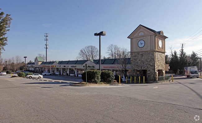
Property Record
12130 Darnestown Rd, Gaithersburg, MD 20878

Property Detail
12130 Darnestown Rd
06-00401643
PT PAR D QUINCE ORCHARD SHOPPING CENTER
Storebuilding
Montgomery
C1
Maryland
B and X Area of moderate flood hazard, usually the area between the limits of the 100-year and 500-year floods.
3.87 AC
2025
Outlying Montgmery Cnty W
2025
Washington, DC
700616
Washington-Arlington-Alexandria, DC-VA-MD-WV
37,625 SF
NEARBY LISTINGS FOR SALE OR LEASE
DEMOGRAPHICS near 12130 Darnestown Rd
1 mile
3 mile
5 mile
2025 Total Population
13,648
89,164
252,834
2030 Population
14,068
91,814
260,413
Pop Growth 2025-2030
+ 3.08%
+ 2.97%
+ 3.00%
Average Age
43
40
40
2025 Total Households
5,119
32,373
91,340
HH Growth 2025-2030
+ 3.03%
+ 2.95%
+ 3.02%
Median Household Inc
$169,269
$131,198
$115,943
Avg Household Size
2.60
2.70
2.70
2025 Avg HH Vehicles
2.00
2.00
2.00
Median Home Value
$720,324
$655,935
$576,133
Median Year Built
1991
1987
1987
Nearby Places
Map Layers
Map Styles
 Street
 Aerial
Layers
 Traffic
 Biking
Places
Listings with unknown addresses are not visible on the map
- Restaurants
- Banks
- Shops
- Fitness
- Groceries
PUBLIC TRANSPORTATION
COMMUTER RAIL
Metropolitan Grove Marc Wb (BRUNSWICK - WASHINGTON - Maryland Transit Administration)
Drive
Walk
Distance
Metropolitan Grove Marc Wb (BRUNSWICK - WASHINGTON - Maryland Transit Administration)
8 min
3.6 mi
Gaithersburg Marc Eb (BRUNSWICK - WASHINGTON - Maryland Transit Administration)
Drive
Walk
Distance
Gaithersburg Marc Eb (BRUNSWICK - WASHINGTON - Maryland Transit Administration)
8 min
4.4 mi
AIRPORT
Ronald Reagan Washington Ntl
Drive
Walk
Distance
Ronald Reagan Washington Ntl
46 min
25.8 mi
Washington Dulles International
Drive
Walk
Distance
Washington Dulles International
51 min
32.1 mi
Freight Ports
Port of Baltimore
Drive
Walk
Distance
Port of Baltimore
62 min
45.9 mi
SALE & LEASE HISTORY
LISTING DATE
SALE/LEASE

Sep 25, 2016
For Lease
Nearby Properties
Address
Land Use
TOTAL SIZE
Lot Size
Zoning
Address
Land Use
TOTAL SIZE
Lot Size
Zoning
849,305 SF
30.78 AC
MXD
Address
Land Use
TOTAL SIZE
Lot Size
Zoning
635,057 SF
28.09 AC
CRT0.
Address
Land Use
TOTAL SIZE
Lot Size
Zoning
290,912 SF
9.55 AC
LSC1.
Address
Land Use
TOTAL SIZE
Lot Size
Zoning
488,864 SF
18.17 AC
CRT0.
Address
Land Use
TOTAL SIZE
Lot Size
Zoning
693,823 SF
5.30 AC
CR2.0
Address
Land Use
TOTAL SIZE
Lot Size
Zoning
450,000 SF
8.53 AC
MXD
Address
Land Use
TOTAL SIZE
Lot Size
Zoning
298,300 SF
7.69 AC
CR1.0
Address
Land Use
TOTAL SIZE
Lot Size
Zoning
24.08 AC
CRT0.
Address
Land Use
TOTAL SIZE
Lot Size
Zoning
363,750 SF
21.16 AC
R60
Address
Land Use
TOTAL SIZE
Lot Size
Zoning
370,422 SF
13.87 AC
CRT1.
Address
Land Use
TOTAL SIZE
Lot Size
Zoning
2,556 SF
555.47 AC
R200
Address
Land Use
TOTAL SIZE
Lot Size
Zoning
85,381 SF
5.86 AC
MXD
Address
Land Use
TOTAL SIZE
Lot Size
Zoning
373,116 SF
51.42 AC
I3
Address
Land Use
TOTAL SIZE
Lot Size
Zoning
1.64 AC
MXD
Address
Land Use
TOTAL SIZE
Lot Size
Zoning
170,689 SF
9.98 AC
LSC1.
Address
Land Use
TOTAL SIZE
Lot Size
Zoning
385,641 SF
2.65 AC
MXD
Address
Land Use
TOTAL SIZE
Lot Size
Zoning
279,442 SF
9.78 AC
CRT1.
Address
Land Use
TOTAL SIZE
Lot Size
Zoning
17.64 AC
MXD
Address
Land Use
TOTAL SIZE
Lot Size
Zoning
427,670 SF
18.36 AC
R20
Address
Land Use
TOTAL SIZE
Lot Size
Zoning
240,000 SF
1.77 AC
MXD
Address
Land Use
TOTAL SIZE
Lot Size
Zoning
462,892 SF
23.84 AC
MXD
Address
Land Use
TOTAL SIZE
Lot Size
Zoning
147,135 SF
8.16 AC
I3
Address
Land Use
TOTAL SIZE
Lot Size
Zoning
138,938 SF
12.72 AC
I3
Address
Land Use
TOTAL SIZE
Lot Size
Zoning
237,414 SF
22.29 AC
MXD
Address
Land Use
TOTAL SIZE
Lot Size
Zoning
191,568 SF
10.68 AC
E1
Address
Land Use
TOTAL SIZE
Lot Size
Zoning
335,000 SF
21.81 AC
R30
Address
Land Use
TOTAL SIZE
Lot Size
Zoning
223,243 SF
22.81 AC
LSC1.
Address
Land Use
TOTAL SIZE
Lot Size
Zoning
303,036 SF
5.10 AC
MXD
Address
Land Use
TOTAL SIZE
Lot Size
Zoning
260,000 SF
7.54 AC
EOF1.
Address
Land Use
TOTAL SIZE
Lot Size
Zoning
306,600 SF
15.54 AC
MXD
The World's #1 Commercial Real Estate Marketplace
Connect with us
© 2026 CoStar Group
The information above has been obtained from sources believed reliable. While we do not doubt its accuracy we have not verified it and make no guarantee, warranty or representation about it. It is your responsibility to independently confirm its accuracy and completeness. Any projections, opinions, assumptions, or estimates used are for example only and do not represent the current or future performance of the property. The value of this transaction to you depends on tax and other factors which should be evaluated by your tax, financial, and legal advisors. You and your advisors should conduct a careful, independent investigation of the property to determine to your satisfaction the suitability of the property for your needs.