Property Record
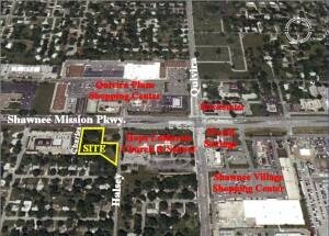
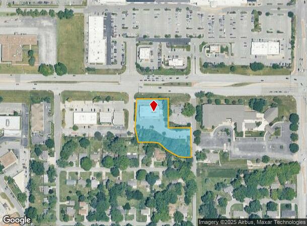
12139 Shawnee Mission Pkwy, Shawnee, KS 66216
NEARBY LISTINGS FOR SALE OR LEASE
Property Detail
12139 Shawnee Mission Pkwy
Kansas City, MO-KS
Noland Acres
QP49600000-0T0B
RESURVEY OF NOLAND ACRES LT 1 CERT OF SUR AS REC BK 5083 P 71 TRACT B EX BG 1014.04 W & 78.57 S NE CR NE1/4 15-12-24 ON SLY RTWY/L SHAWNEE MISSION PKWY S 168.37NW 172.55 E 48.30 TO POB SHC 513D 1A B
Regionalshoppingcenterormallwithanchorstore
Johnson
X
Kansas
20209C0165D
1
2024
1.74 AC
2024
Northwest Johnson County
052304
Kansas City
8,096 SF
DEMOGRAPHICS near 12139 Shawnee Mission Pkwy
1 Mile
3 Mile
5 Mile
2024 Total Population
10,678
76,966
188,903
2029 Population
11,083
79,713
194,746
Pop Growth 2024-2029
+ 3.79%
+ 3.57%
+ 3.09%
Average Age
41
40
40
2024 Total Households
4,472
32,745
82,184
HH Growth 2024-2029
+ 3.85%
+ 3.76%
+ 3.37%
Median Household Inc
$71,703
$74,362
$74,023
Avg Household Size
2.30
2.30
2.20
2024 Avg HH Vehicles
2.00
2.00
2.00
Median Home Value
$215,362
$261,465
$256,916
Median Year Built
1970
1975
1971
Nearby Places
Map Layers
Map Styles
 Street
 Aerial
- Restaurants
- Banks
- Shops
- Fitness
- Groceries
PUBLIC TRANSPORTATION
AIRPORT
Kansas City International
DRIVE
WALK
Distance
Kansas City International
38 min
28.5 mi
Nearby Properties
Address
Land Use
TOTAL SIZE
Lot Size
Zoning
Address
Land Use
TOTAL SIZE
Lot Size
Zoning
857,568 SF
38.48 AC
PUD-G
Address
Land Use
TOTAL SIZE
Lot Size
Zoning
279,588 SF
19.50 AC
RP5
Address
Land Use
TOTAL SIZE
Lot Size
Zoning
203,079 SF
8.10 AC
BP2
Address
Land Use
TOTAL SIZE
Lot Size
Zoning
202,842 SF
10.20 AC
PD
Address
Land Use
TOTAL SIZE
Lot Size
Zoning
133,505 SF
16.41 AC
R-1
Address
Land Use
TOTAL SIZE
Lot Size
Zoning
83,537 SF
27.65 AC
AG
Address
Land Use
TOTAL SIZE
Lot Size
Zoning
96,501 SF
6.49 AC
Address
Land Use
TOTAL SIZE
Lot Size
Zoning
89,477 SF
16.45 AC
R-1
Address
Land Use
TOTAL SIZE
Lot Size
Zoning
75,010 SF
5.53 AC
PD
Address
Land Use
TOTAL SIZE
Lot Size
Zoning
63,471 SF
7.36 AC
PARK
Address
Land Use
TOTAL SIZE
Lot Size
Zoning
85,940 SF
9.08 AC
RGA
Address
Land Use
TOTAL SIZE
Lot Size
Zoning
96,856 SF
15.76 AC
R-1
Address
Land Use
TOTAL SIZE
Lot Size
Zoning
139,880 SF
17.18 AC
R1
Address
Land Use
TOTAL SIZE
Lot Size
Zoning
88,866 SF
21.54 AC
RS
Address
Land Use
TOTAL SIZE
Lot Size
Zoning
93,418 SF
12.07 AC
R-1
Address
Land Use
TOTAL SIZE
Lot Size
Zoning
81,361 SF
3.81 AC
AG
Address
Land Use
TOTAL SIZE
Lot Size
Zoning
37,499 SF
3.72 AC
PUD-G
Address
Land Use
TOTAL SIZE
Lot Size
Zoning
70,952 SF
9.98 AC
R-1
Address
Land Use
TOTAL SIZE
Lot Size
Zoning
85,469 SF
10.32 AC
CPO
Address
Land Use
TOTAL SIZE
Lot Size
Zoning
77,758 SF
4.89 AC
R-1
Address
Land Use
TOTAL SIZE
Lot Size
Zoning
35,848 SF
74.74 AC
R1
Address
Land Use
TOTAL SIZE
Lot Size
Zoning
311,454 SF
40.91 AC
PUD-G
Address
Land Use
TOTAL SIZE
Lot Size
Zoning
667,586 SF
18.06 AC
PUD-G
Address
Land Use
TOTAL SIZE
Lot Size
Zoning
34,745 SF
8.96 AC
PARK
Address
Land Use
TOTAL SIZE
Lot Size
Zoning
34,641 SF
14.33 AC
AG
Address
Land Use
TOTAL SIZE
Lot Size
Zoning
42,603 SF
17.67 AC
AG
Address
Land Use
TOTAL SIZE
Lot Size
Zoning
34,366 SF
11.53 AC
R-1
Address
Land Use
TOTAL SIZE
Lot Size
Zoning
66,314 SF
8.47 AC
R1
Address
Land Use
TOTAL SIZE
Lot Size
Zoning
80,474 SF
11.30 AC
R-1
Address
Land Use
TOTAL SIZE
Lot Size
Zoning
297,730 SF
15.75 AC
CN
The World's #1 Commercial Real Estate Marketplace
Connect with us
© 2025 CoStar Group
The information above has been obtained from sources believed reliable. While we do not doubt its accuracy we have not verified it and make no guarantee, warranty or representation about it. It is your responsibility to independently confirm its accuracy and completeness. Any projections, opinions, assumptions, or estimates used are for example only and do not represent the current or future performance of the property. The value of this transaction to you depends on tax and other factors which should be evaluated by your tax, financial, and legal advisors. You and your advisors should conduct a careful, independent investigation of the property to determine to your satisfaction the suitability of the property for your needs.