Property Record
1215 15Th St, Moline, IL 61265
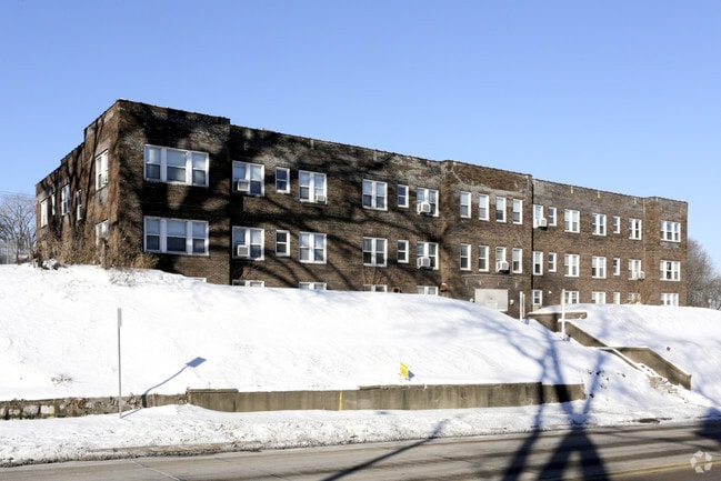

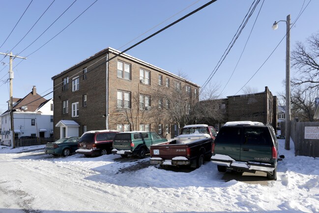
Property Detail
1215 15Th St
17-05-202-009
LOT 1 BLOCK 1 MOLINE ON THE BLUFF ADD ALL EX W 60 & ALL EX W 60 OF N 30 L 2 & N 40 L 3
Commercialnec
Rock Island
MOL
Illinois
B and X Area of moderate flood hazard, usually the area between the limits of the 100-year and 500-year floods.
1
2025
0.64 AC
2024
Uptown Moline
021700
Davenport/Moline/Rock Island
31,248 SF
Davenport-Moline-Rock Island, IA-IL
NEARBY LISTINGS FOR SALE OR LEASE
-
-
View all Moline listings for sale on LoopNet.com
DEMOGRAPHICS near 1215 15Th St
1 mile
3 mile
5 mile
2025 Total Population
14,333
72,182
173,485
2030 Population
14,256
72,030
174,300
Pop Growth 2025-2030
(0.54%)
(0.21%)
+ 0.47%
Average Age
38
40
40
2025 Total Households
5,966
30,674
73,713
HH Growth 2025-2030
(0.50%)
(0.22%)
+ 0.54%
Median Household Inc
$51,700
$63,227
$64,292
Avg Household Size
2.30
2.20
2.20
2025 Avg HH Vehicles
2.00
2.00
2.00
Median Home Value
$139,904
$158,488
$166,535
Median Year Built
1946
1951
1957
Nearby Places
Map Layers
Map Styles
 Street
 Aerial
Layers
 Traffic
 Biking
Places
Listings with unknown addresses are not visible on the map
- Restaurants
- Banks
- Shops
- Fitness
- Groceries
PUBLIC TRANSPORTATION
AIRPORT
Quad Cities International
Drive
Walk
Distance
Quad Cities International
11 min
4.6 mi
Nearby Properties
Address
Land Use
TOTAL SIZE
Lot Size
Zoning
Address
Land Use
TOTAL SIZE
Lot Size
Zoning
157,798 SF
25.37 AC
Address
Land Use
TOTAL SIZE
Lot Size
Zoning
76,808 SF
1.94 AC
Address
Land Use
TOTAL SIZE
Lot Size
Zoning
65,958 SF
15.04 AC
Address
Land Use
TOTAL SIZE
Lot Size
Zoning
71,108 SF
8.99 AC
Address
Land Use
TOTAL SIZE
Lot Size
Zoning
40,307 SF
1.25 AC
Address
Land Use
TOTAL SIZE
Lot Size
Zoning
67,439 SF
2.02 AC
Address
Land Use
TOTAL SIZE
Lot Size
Zoning
79,949 SF
2.63 AC
Address
Land Use
TOTAL SIZE
Lot Size
Zoning
2,400 SF
228.12 AC
Address
Land Use
TOTAL SIZE
Lot Size
Zoning
59,668 SF
7.80 AC
Address
Land Use
TOTAL SIZE
Lot Size
Zoning
96,335 SF
8.83 AC
Address
Land Use
TOTAL SIZE
Lot Size
Zoning
29,883 SF
5.80 AC
Address
Land Use
TOTAL SIZE
Lot Size
Zoning
7.86 AC
Address
Land Use
TOTAL SIZE
Lot Size
Zoning
21,273 SF
8.98 AC
Address
Land Use
TOTAL SIZE
Lot Size
Zoning
21,273 SF
8.98 AC
Address
Land Use
TOTAL SIZE
Lot Size
Zoning
28,292 SF
3.76 AC
Address
Land Use
TOTAL SIZE
Lot Size
Zoning
52,742 SF
6.09 AC
Address
Land Use
TOTAL SIZE
Lot Size
Zoning
5,816 SF
6.87 AC
Address
Land Use
TOTAL SIZE
Lot Size
Zoning
108,500 SF
2.41 AC
MOL
Address
Land Use
TOTAL SIZE
Lot Size
Zoning
3,916 SF
9.30 AC
Address
Land Use
TOTAL SIZE
Lot Size
Zoning
13,440 SF
15.87 AC
Address
Land Use
TOTAL SIZE
Lot Size
Zoning
8.16 AC
MOL
Address
Land Use
TOTAL SIZE
Lot Size
Zoning
100,500 SF
0.94 AC
MOL
Address
Land Use
TOTAL SIZE
Lot Size
Zoning
1,287,769 SF
53.54 AC
MOL
Address
Land Use
TOTAL SIZE
Lot Size
Zoning
50,853 SF
1.29 AC
Address
Land Use
TOTAL SIZE
Lot Size
Zoning
2,744 SF
10.25 AC
Address
Land Use
TOTAL SIZE
Lot Size
Zoning
9,325 SF
12.38 AC
Address
Land Use
TOTAL SIZE
Lot Size
Zoning
250,875 SF
11.92 AC
MOL
Address
Land Use
TOTAL SIZE
Lot Size
Zoning
79,631 SF
6.86 AC
Address
Land Use
TOTAL SIZE
Lot Size
Zoning
369,922 SF
3.14 AC
RI
The World's #1 Commercial Real Estate Marketplace
Connect with us
© 2026 CoStar Group
The information above has been obtained from sources believed reliable. While we do not doubt its accuracy we have not verified it and make no guarantee, warranty or representation about it. It is your responsibility to independently confirm its accuracy and completeness. Any projections, opinions, assumptions, or estimates used are for example only and do not represent the current or future performance of the property. The value of this transaction to you depends on tax and other factors which should be evaluated by your tax, financial, and legal advisors. You and your advisors should conduct a careful, independent investigation of the property to determine to your satisfaction the suitability of the property for your needs.