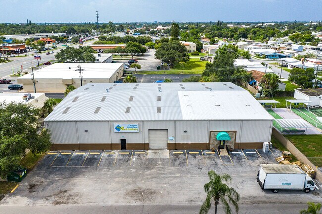
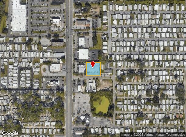
Property Record
1215 50Th Avenue Plz W, Bradenton, FL 34207


NEARBY LISTINGS FOR SALE OR LEASE
Property Detail
1215 50Th Avenue Plz W
54400-0000-7
Acreage & Unrec
Warehouse
COM AT NW COR OF S1/2 OF NE1/4 OF SW1/4 OF SEC 11, GO N 88 DEG 16 MIN 18 SEC E, 24.99 FT TO E R/W LN OF U S 41; CTD N 88 DEG 16 MIN 18 SEC E 151 FT FOR A POB; N 88 DEG 16 MIN 18
AE
Manatee
12115C0050F
Florida
2024
0.57 AC
2025
Manatee
000201
Tampa/St Petersburg
11,500 SF
North Port-Sarasota-Bradenton, FL
DEMOGRAPHICS near 1215 50Th Avenue Plz W
1 Mile
3 Mile
5 Mile
2024 Total Population
22,299
121,724
200,390
2029 Population
26,374
141,848
233,961
Pop Growth 2024-2029
+ 18.27%
+ 16.53%
+ 16.75%
Average Age
43
43
45
2024 Total Households
9,873
50,633
83,986
HH Growth 2024-2029
+ 17.15%
+ 15.86%
+ 16.03%
Median Household Inc
$40,397
$45,272
$50,744
Avg Household Size
2.20
2.30
2.30
2024 Avg HH Vehicles
1.00
2.00
2.00
Median Home Value
$80,971
$164,078
$220,793
Median Year Built
1975
1976
1979
Nearby Places
Map Layers
Map Styles
 Street
 Aerial
- Restaurants
- Banks
- Shops
- Fitness
- Groceries
PUBLIC TRANSPORTATION
AIRPORT
Sarasota/Bradenton International
DRIVE
WALK
Distance
Sarasota/Bradenton International
10 min
4.8 mi
St Pete-Clearwater International
DRIVE
WALK
Distance
St Pete-Clearwater International
53 min
38.7 mi
Freight Ports
Port Manatee
DRIVE
WALK
Distance
Port Manatee
26 min
14.8 mi
SALE & LEASE HISTORY
LISTING DATE
SALE/LEASE

Aug 05, 2020
For Sale
Nearby Properties
Address
Land Use
TOTAL SIZE
Lot Size
Zoning
Address
Land Use
TOTAL SIZE
Lot Size
Zoning
623,436 SF
88.25 AC
PD-R,MP-I
Address
Land Use
TOTAL SIZE
Lot Size
Zoning
349,711 SF
49.51 AC
BR_SD1
Address
Land Use
TOTAL SIZE
Lot Size
Zoning
437,460 SF
46.14 AC
PD-R
Address
Land Use
TOTAL SIZE
Lot Size
Zoning
456,263 SF
28.02 AC
BR_R-3
Address
Land Use
TOTAL SIZE
Lot Size
Zoning
314,018 SF
28.20 AC
BR_R-3
Address
Land Use
TOTAL SIZE
Lot Size
Zoning
645,805 SF
91.21 AC
PD-PI
Address
Land Use
TOTAL SIZE
Lot Size
Zoning
279,545 SF
19.41 AC
BR_R-1
Address
Land Use
TOTAL SIZE
Lot Size
Zoning
432,078 SF
1.64 AC
BR_T6
Address
Land Use
TOTAL SIZE
Lot Size
Zoning
507,194 SF
8.49 AC
Address
Land Use
TOTAL SIZE
Lot Size
Zoning
2,401,721 SF
142.14 AC
PD-UI
Address
Land Use
TOTAL SIZE
Lot Size
Zoning
247,280 SF
17.72 AC
PD-R
Address
Land Use
TOTAL SIZE
Lot Size
Zoning
294,609 SF
19.15 AC
RMF9
Address
Land Use
TOTAL SIZE
Lot Size
Zoning
117,547 SF
11.64 AC
MP-I
Address
Land Use
TOTAL SIZE
Lot Size
Zoning
153,663 SF
110.35 AC
MP-I
Address
Land Use
TOTAL SIZE
Lot Size
Zoning
375,171 SF
20 AC
PD-MU
Address
Land Use
TOTAL SIZE
Lot Size
Zoning
214,906 SF
20.71 AC
BR_R-1
Address
Land Use
TOTAL SIZE
Lot Size
Zoning
500,923 SF
47.91 AC
Address
Land Use
TOTAL SIZE
Lot Size
Zoning
223,974 SF
17.41 AC
BR_R-2
Address
Land Use
TOTAL SIZE
Lot Size
Zoning
397,863 SF
21.60 AC
GC GENERA
Address
Land Use
TOTAL SIZE
Lot Size
Zoning
318,680 SF
1.31 AC
BR_FBC,BR_
Address
Land Use
TOTAL SIZE
Lot Size
Zoning
335,019 SF
32.58 AC
BR_R-3
Address
Land Use
TOTAL SIZE
Lot Size
Zoning
247,592 SF
13.39 AC
GC,RMF-6
Address
Land Use
TOTAL SIZE
Lot Size
Zoning
198,036 SF
8.32 AC
GC GENERA
Address
Land Use
TOTAL SIZE
Lot Size
Zoning
331,144 SF
40.48 AC
PD-PI
Address
Land Use
TOTAL SIZE
Lot Size
Zoning
115,400 SF
22.55 AC
LM LIGHT M
Address
Land Use
TOTAL SIZE
Lot Size
Zoning
159,960 SF
11.30 AC
RMF-9 MULT
Address
Land Use
TOTAL SIZE
Lot Size
Zoning
185,617 SF
13.68 AC
BR_R-2
Address
Land Use
TOTAL SIZE
Lot Size
Zoning
187,000 SF
8.93 AC
Address
Land Use
TOTAL SIZE
Lot Size
Zoning
166,810 SF
3.16 AC
BR_T4-O
Address
Land Use
TOTAL SIZE
Lot Size
Zoning
214,350 SF
16.07 AC
LM LIGHT M
The World's #1 Commercial Real Estate Marketplace
Connect with us
© 2025 CoStar Group
The information above has been obtained from sources believed reliable. While we do not doubt its accuracy we have not verified it and make no guarantee, warranty or representation about it. It is your responsibility to independently confirm its accuracy and completeness. Any projections, opinions, assumptions, or estimates used are for example only and do not represent the current or future performance of the property. The value of this transaction to you depends on tax and other factors which should be evaluated by your tax, financial, and legal advisors. You and your advisors should conduct a careful, independent investigation of the property to determine to your satisfaction the suitability of the property for your needs.