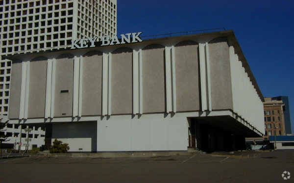
Property Record
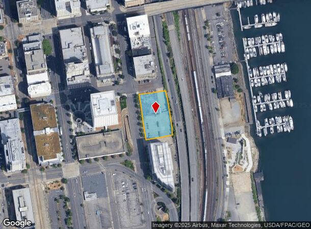
1215 Barnes Blvd, Joint Base Lewis Mcchord, WA 98438

NEARBY LISTINGS FOR SALE OR LEASE
Property Detail
1215 Barnes Blvd
032004-2034
SECTION 04 TOWNSHIP 20 RANGE 03 QUARTER 24 PARCEL 2 OF DBLA 2000-03-06-5006 DESC AS FOLL COM AT A PT WHERE NLY BDRY OF S 13TH ST PRODUCED ELY INTER ELY BDRY OF A ST SD PT BEING SW COR OF B 1201 OF MAP OF NEW TACOMA PLAT TH N 07 DEG 19 MIN 38 SEC W AL
Parkinglot
Pierce
X
Washington
53033C1225G
0.88 AC
2024
Tacoma CBD
2025
Seattle/Puget Sound
072901
Seattle-Tacoma-Bellevue, WA
DEMOGRAPHICS near 1215 Barnes Blvd
1 Mile
3 Mile
5 Mile
2024 Total Population
18,450
94,120
263,914
2029 Population
19,371
97,204
271,315
Pop Growth 2024-2029
+ 4.99%
+ 3.28%
+ 2.80%
Average Age
39
38
39
2024 Total Households
8,948
39,175
104,695
HH Growth 2024-2029
+ 5.68%
+ 3.55%
+ 3.03%
Median Household Inc
$54,297
$73,267
$79,261
Avg Household Size
1.70
2.20
2.40
2024 Avg HH Vehicles
1.00
2.00
2.00
Median Home Value
$448,750
$441,204
$450,292
Median Year Built
1977
1951
1972
Nearby Places
Map Layers
Map Styles
 Street
 Aerial
- Restaurants
- Banks
- Shops
- Fitness
- Groceries
PUBLIC TRANSPORTATION
TRANSIT/SUBWAY
Commerce Street Station (Tacoma Dome - Commerce St. - Sound Transit, Tacoma Dome - St Joseph - Sound Transit)
DRIVE
WALK
Distance
Commerce Street Station (Tacoma Dome - Commerce St. - Sound Transit, Tacoma Dome - St Joseph - Sound Transit)
1 min
4 min
0.2 mi
Convention Center/South 15Th (Tacoma Link - Central Puget Sound Regional Transit Authority Rail (Link Light Rail/Sounder))
DRIVE
WALK
Distance
Convention Center/South 15Th (Tacoma Link - Central Puget Sound Regional Transit Authority Rail (Link Light Rail/Sounder))
1 min
5 min
0.3 mi
Theater District/South 9Th (Tacoma Link - Central Puget Sound Regional Transit Authority Rail (Link Light Rail/Sounder))
DRIVE
WALK
Distance
Theater District/South 9Th (Tacoma Link - Central Puget Sound Regional Transit Authority Rail (Link Light Rail/Sounder))
1 min
8 min
0.5 mi
Union Station/South 19Th (Tacoma Link - Central Puget Sound Regional Transit Authority Rail (Link Light Rail/Sounder))
DRIVE
WALK
Distance
Union Station/South 19Th (Tacoma Link - Central Puget Sound Regional Transit Authority Rail (Link Light Rail/Sounder))
2 min
10 min
0.6 mi
Old City Hall (Tacoma Dome - St Joseph - Sound Transit)
DRIVE
WALK
Distance
Old City Hall (Tacoma Dome - St Joseph - Sound Transit)
1 min
11 min
0.6 mi
COMMUTER RAIL
Tacoma Dome Station (Seattle - Tacoma/Lakewood - Sound Transit, Sounder South Line - Sound Transit, Tacoma Link - Sound Transit)
DRIVE
WALK
Distance
Tacoma Dome Station (Seattle - Tacoma/Lakewood - Sound Transit, Sounder South Line - Sound Transit, Tacoma Link - Sound Transit)
4 min
1.6 mi
South Tacoma Station (Seattle - Tacoma/Lakewood - Sound Transit)
DRIVE
WALK
Distance
South Tacoma Station (Seattle - Tacoma/Lakewood - Sound Transit)
9 min
5.3 mi
AIRPORT
Seattle-Tacoma International
DRIVE
WALK
Distance
Seattle-Tacoma International
36 min
22.2 mi
Freight Ports
Port of Tacoma
DRIVE
WALK
Distance
Port of Tacoma
5 min
2.0 mi
Nearby Properties
Address
Land Use
TOTAL SIZE
Lot Size
Zoning
Address
Land Use
TOTAL SIZE
Lot Size
Zoning
1,173,718 SF
79.33 AC
R2
Address
Land Use
TOTAL SIZE
Lot Size
Zoning
756,321 SF
8.90 AC
DMU
Address
Land Use
TOTAL SIZE
Lot Size
Zoning
498,913 SF
1.18 AC
HMX
Address
Land Use
TOTAL SIZE
Lot Size
Zoning
1 SF
83.72 AC
PMI
Address
Land Use
TOTAL SIZE
Lot Size
Zoning
361,000 SF
1.15 AC
HMX
Address
Land Use
TOTAL SIZE
Lot Size
Zoning
326,080 SF
1.67 AC
HMX
Address
Land Use
TOTAL SIZE
Lot Size
Zoning
515,971 SF
42.45 AC
Address
Land Use
TOTAL SIZE
Lot Size
Zoning
1 SF
150.54 AC
S10
Address
Land Use
TOTAL SIZE
Lot Size
Zoning
6,794 SF
127.94 AC
S10
Address
Land Use
TOTAL SIZE
Lot Size
Zoning
828,620 SF
40.92 AC
Address
Land Use
TOTAL SIZE
Lot Size
Zoning
161,799 SF
108.15 AC
PMI
Address
Land Use
TOTAL SIZE
Lot Size
Zoning
10,800 SF
85.18 AC
PMI
Address
Land Use
TOTAL SIZE
Lot Size
Zoning
582,536 SF
32.67 AC
I
Address
Land Use
TOTAL SIZE
Lot Size
Zoning
1 SF
8.63 AC
M2
Address
Land Use
TOTAL SIZE
Lot Size
Zoning
175,800 SF
76.02 AC
PMI
Address
Land Use
TOTAL SIZE
Lot Size
Zoning
220,618 SF
26 AC
DMU
Address
Land Use
TOTAL SIZE
Lot Size
Zoning
588,800 SF
37.43 AC
I
Address
Land Use
TOTAL SIZE
Lot Size
Zoning
138,020 SF
0.93 AC
HMX
Address
Land Use
TOTAL SIZE
Lot Size
Zoning
542,750 SF
26.77 AC
TAC
Address
Land Use
TOTAL SIZE
Lot Size
Zoning
448,900 SF
0.76 AC
DCC
Address
Land Use
TOTAL SIZE
Lot Size
Zoning
10,000 SF
59.94 AC
S10
Address
Land Use
TOTAL SIZE
Lot Size
Zoning
191,430 SF
2.50 AC
PMI
Address
Land Use
TOTAL SIZE
Lot Size
Zoning
1 SF
55.09 AC
PMI
Address
Land Use
TOTAL SIZE
Lot Size
Zoning
59,760 SF
78.60 AC
S10
Address
Land Use
TOTAL SIZE
Lot Size
Zoning
18,860 SF
35.98 AC
S10
Address
Land Use
TOTAL SIZE
Lot Size
Zoning
208,168 SF
2.28 AC
HMX
Address
Land Use
TOTAL SIZE
Lot Size
Zoning
1 SF
49.87 AC
S10
Address
Land Use
TOTAL SIZE
Lot Size
Zoning
279,294 SF
74.24 AC
S13
Address
Land Use
TOTAL SIZE
Lot Size
Zoning
157,456 SF
1.19 AC
S8
Address
Land Use
TOTAL SIZE
Lot Size
Zoning
223,447 SF
40.44 AC
RCX
The World's #1 Commercial Real Estate Marketplace
Connect with us
© 2025 CoStar Group
The information above has been obtained from sources believed reliable. While we do not doubt its accuracy we have not verified it and make no guarantee, warranty or representation about it. It is your responsibility to independently confirm its accuracy and completeness. Any projections, opinions, assumptions, or estimates used are for example only and do not represent the current or future performance of the property. The value of this transaction to you depends on tax and other factors which should be evaluated by your tax, financial, and legal advisors. You and your advisors should conduct a careful, independent investigation of the property to determine to your satisfaction the suitability of the property for your needs.