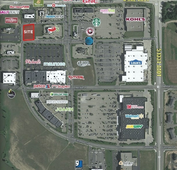
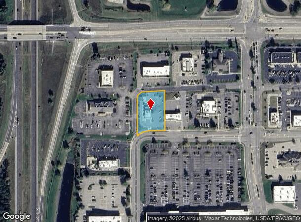
Property Record
1215 Commons Cir, Plover, WI 54467
NEARBY LISTINGS FOR SALE OR LEASE
Property Detail
1215 Commons Cir
Stevens Point-Plover, WI
Portage County Certified Survey Map No 1
173-23-0811-02.02
LOT 1, CSM#11317 DOC-858647; BNG PRT NWNE S11 T23 R08SUBJ RC & AGMTS -662243;678564;680808;704438 &833764;ING/EGR ESMT-70182;
Commercialnec
Portage
X
Wisconsin
55097C0335D
1
2024
0.81 AC
2024
Wausau/Stevens Point
960701
Other Market Areas
DEMOGRAPHICS near 1215 Commons Cir
1 mile
3 mile
5 mile
2024 Total Population
2,455
22,620
48,230
2029 Population
2,477
23,003
49,130
Pop Growth 2024-2029
+ 0.90%
+ 1.69%
+ 1.87%
Average Age
40
42
39
2024 Total Households
1,104
9,923
20,266
HH Growth 2024-2029
+ 1.00%
+ 1.75%
+ 1.97%
Median Household Inc
$71,692
$68,161
$62,083
Avg Household Size
2.20
2.20
2.20
2024 Avg HH Vehicles
2.00
2.00
2.00
Median Home Value
$178,924
$185,365
$177,031
Median Year Built
1990
1983
1980
Nearby Places
Map Layers
Map Styles
 Street
 Aerial
Transit
 Traffic
 Biking
Places
Listings with unknown addresses are not visible on the map
- Restaurants
- Banks
- Shops
- Fitness
- Groceries
PUBLIC TRANSPORTATION
AIRPORT
Central Wisconsin
Drive
Walk
Distance
Central Wisconsin
29 min
24.2 mi
SALE & LEASE HISTORY
LISTING DATE
SALE/LEASE

May 11, 2021
For Sale
Mar 06, 2020
For Lease
Nearby Properties
Address
Land Use
TOTAL SIZE
Lot Size
Zoning
Address
Land Use
TOTAL SIZE
Lot Size
Zoning
27.31 AC
Address
Land Use
TOTAL SIZE
Lot Size
Zoning
43.36 AC
Address
Land Use
TOTAL SIZE
Lot Size
Zoning
Address
Land Use
TOTAL SIZE
Lot Size
Zoning
Address
Land Use
TOTAL SIZE
Lot Size
Zoning
Address
Land Use
TOTAL SIZE
Lot Size
Zoning
20.78 AC
Address
Land Use
TOTAL SIZE
Lot Size
Zoning
11.03 AC
Address
Land Use
TOTAL SIZE
Lot Size
Zoning
Address
Land Use
TOTAL SIZE
Lot Size
Zoning
20.95 AC
Address
Land Use
TOTAL SIZE
Lot Size
Zoning
12.44 AC
Address
Land Use
TOTAL SIZE
Lot Size
Zoning
Address
Land Use
TOTAL SIZE
Lot Size
Zoning
Address
Land Use
TOTAL SIZE
Lot Size
Zoning
Address
Land Use
TOTAL SIZE
Lot Size
Zoning
17.36 AC
Address
Land Use
TOTAL SIZE
Lot Size
Zoning
Address
Land Use
TOTAL SIZE
Lot Size
Zoning
Address
Land Use
TOTAL SIZE
Lot Size
Zoning
13.15 AC
Address
Land Use
TOTAL SIZE
Lot Size
Zoning
28.75 AC
Address
Land Use
TOTAL SIZE
Lot Size
Zoning
11.24 AC
Address
Land Use
TOTAL SIZE
Lot Size
Zoning
Address
Land Use
TOTAL SIZE
Lot Size
Zoning
11.97 AC
Address
Land Use
TOTAL SIZE
Lot Size
Zoning
Address
Land Use
TOTAL SIZE
Lot Size
Zoning
Address
Land Use
TOTAL SIZE
Lot Size
Zoning
7.78 AC
Address
Land Use
TOTAL SIZE
Lot Size
Zoning
10.04 AC
Address
Land Use
TOTAL SIZE
Lot Size
Zoning
Address
Land Use
TOTAL SIZE
Lot Size
Zoning
9.22 AC
Address
Land Use
TOTAL SIZE
Lot Size
Zoning
14.76 AC
Address
Land Use
TOTAL SIZE
Lot Size
Zoning
5.95 AC
Address
Land Use
TOTAL SIZE
Lot Size
Zoning
10.04 AC
The World's #1 Commercial Real Estate Marketplace
Connect with us
© 2026 CoStar Group
The information above has been obtained from sources believed reliable. While we do not doubt its accuracy we have not verified it and make no guarantee, warranty or representation about it. It is your responsibility to independently confirm its accuracy and completeness. Any projections, opinions, assumptions, or estimates used are for example only and do not represent the current or future performance of the property. The value of this transaction to you depends on tax and other factors which should be evaluated by your tax, financial, and legal advisors. You and your advisors should conduct a careful, independent investigation of the property to determine to your satisfaction the suitability of the property for your needs.