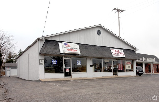
Property Record
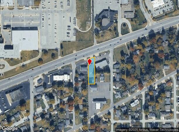
1215 E Main St, Plainfield, IN 46168

NEARBY LISTINGS FOR SALE OR LEASE
Property Detail
1215 E Main St
32-10-26-470-010.000-012
PT SW SE 26-15-1E .42AC BY SURVEY DBA: HARDIN HEATING & KATIES PROFESSIONAL DOG GROOMING LLC
Storebuilding
Hendricks
X
Indiana
18109C0025E
0.42 AC
2024
Hendricks County
2024
Indianapolis
210802
Indianapolis-Carmel-Greenwood, IN
4,000 SF
DEMOGRAPHICS near 1215 E Main St
1 mile
3 mile
5 mile
2024 Total Population
8,954
46,715
83,806
2029 Population
10,001
52,245
92,607
Pop Growth 2024-2029
+ 11.69%
+ 11.84%
+ 10.50%
Average Age
40
39
39
2024 Total Households
3,791
17,006
30,606
HH Growth 2024-2029
+ 11.76%
+ 12.00%
+ 10.70%
Median Household Inc
$62,161
$84,874
$83,619
Avg Household Size
2.30
2.50
2.60
2024 Avg HH Vehicles
2.00
2.00
2.00
Median Home Value
$187,499
$239,501
$233,212
Median Year Built
1967
1995
1997
Nearby Places
Map Layers
Map Styles
 Street
 Aerial
Transit
 Traffic
 Biking
Places
Listings with unknown addresses are not visible on the map
- Restaurants
- Banks
- Shops
- Fitness
- Groceries
PUBLIC TRANSPORTATION
AIRPORT
Indianapolis International
Drive
Walk
Distance
Indianapolis International
15 min
6.4 mi
Freight Ports
Port of Toledo
Drive
Walk
Distance
Port of Toledo
291 min
238.3 mi
Nearby Properties
Address
Land Use
TOTAL SIZE
Lot Size
Zoning
Address
Land Use
TOTAL SIZE
Lot Size
Zoning
1,099,200 SF
68.67 AC
Address
Land Use
TOTAL SIZE
Lot Size
Zoning
1,200,420 SF
68.50 AC
Address
Land Use
TOTAL SIZE
Lot Size
Zoning
939,854 SF
54.08 AC
Address
Land Use
TOTAL SIZE
Lot Size
Zoning
796,988 SF
48.51 AC
Address
Land Use
TOTAL SIZE
Lot Size
Zoning
925,740 SF
82.23 AC
Address
Land Use
TOTAL SIZE
Lot Size
Zoning
950,625 SF
58.11 AC
Address
Land Use
TOTAL SIZE
Lot Size
Zoning
41.50 AC
Address
Land Use
TOTAL SIZE
Lot Size
Zoning
923,980 SF
60.08 AC
Address
Land Use
TOTAL SIZE
Lot Size
Zoning
811,536 SF
42.04 AC
Address
Land Use
TOTAL SIZE
Lot Size
Zoning
822,500 SF
45.66 AC
Address
Land Use
TOTAL SIZE
Lot Size
Zoning
9,728 SF
23.10 AC
Address
Land Use
TOTAL SIZE
Lot Size
Zoning
813,054 SF
45.32 AC
Address
Land Use
TOTAL SIZE
Lot Size
Zoning
43.94 AC
Address
Land Use
TOTAL SIZE
Lot Size
Zoning
770,712 SF
56.53 AC
Address
Land Use
TOTAL SIZE
Lot Size
Zoning
799,264 SF
43.44 AC
Address
Land Use
TOTAL SIZE
Lot Size
Zoning
629,200 SF
39.74 AC
Address
Land Use
TOTAL SIZE
Lot Size
Zoning
706,250 SF
50.53 AC
Address
Land Use
TOTAL SIZE
Lot Size
Zoning
702,000 SF
42.11 AC
Address
Land Use
TOTAL SIZE
Lot Size
Zoning
64.63 AC
Address
Land Use
TOTAL SIZE
Lot Size
Zoning
702,000 SF
36.88 AC
Address
Land Use
TOTAL SIZE
Lot Size
Zoning
5,064 SF
25.50 AC
Address
Land Use
TOTAL SIZE
Lot Size
Zoning
750,820 SF
64.15 AC
Address
Land Use
TOTAL SIZE
Lot Size
Zoning
31.20 AC
Address
Land Use
TOTAL SIZE
Lot Size
Zoning
747,256 SF
41.32 AC
Address
Land Use
TOTAL SIZE
Lot Size
Zoning
720,000 SF
39.03 AC
Address
Land Use
TOTAL SIZE
Lot Size
Zoning
595,938 SF
35.31 AC
Address
Land Use
TOTAL SIZE
Lot Size
Zoning
51,884 SF
14.73 AC
Address
Land Use
TOTAL SIZE
Lot Size
Zoning
650,960 SF
31.95 AC
Address
Land Use
TOTAL SIZE
Lot Size
Zoning
594,848 SF
52.03 AC
Address
Land Use
TOTAL SIZE
Lot Size
Zoning
651,610 SF
63.52 AC
The World's #1 Commercial Real Estate Marketplace
Connect with us
© 2026 CoStar Group
The information above has been obtained from sources believed reliable. While we do not doubt its accuracy we have not verified it and make no guarantee, warranty or representation about it. It is your responsibility to independently confirm its accuracy and completeness. Any projections, opinions, assumptions, or estimates used are for example only and do not represent the current or future performance of the property. The value of this transaction to you depends on tax and other factors which should be evaluated by your tax, financial, and legal advisors. You and your advisors should conduct a careful, independent investigation of the property to determine to your satisfaction the suitability of the property for your needs.