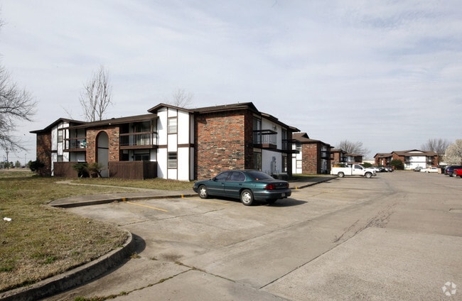
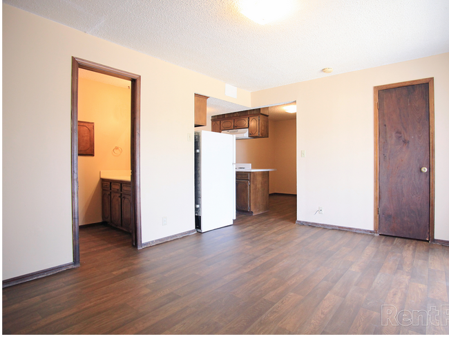
Property Record
1215 Foxcroft Cir, Muskogee, OK 74403

Property Detail
1215 Foxcroft Cir
Muskogee, OK
T15N R19E S31 FARMLAND IN MUSKOGEE S22.78A LT 10 LS W440 N470 & LS BEG AT SW/C E725.04 NELY 460.55 WLY 880.35 SLY 433.49 TO P
14085
Muskogee
Highriseapartments
Oklahoma
B and X Area of moderate flood hazard, usually the area between the limits of the 100-year and 500-year floods.
10,n470
2025
10.04 AC
2025
Muskogee County
000801
Tulsa
9,174 SF
NEARBY LISTINGS FOR SALE OR LEASE
-
-
View all Muskogee listings for sale on LoopNet.com
DEMOGRAPHICS near 1215 Foxcroft Cir
1 mile
3 mile
5 mile
2025 Total Population
6,198
25,311
40,388
2030 Population
6,213
25,683
40,979
Pop Growth 2025-2030
+ 0.24%
+ 1.47%
+ 1.46%
Average Age
40
39
39
2025 Total Households
2,639
10,099
16,298
HH Growth 2025-2030
+ 0.27%
+ 1.55%
+ 1.53%
Median Household Inc
$59,065
$54,373
$51,556
Avg Household Size
2.20
2.40
2.30
2025 Avg HH Vehicles
2.00
2.00
2.00
Median Home Value
$150,070
$133,372
$144,415
Median Year Built
1974
1971
1971
Nearby Places
Map Layers
Map Styles
 Street
 Aerial
Layers
 Traffic
 Biking
Places
Listings with unknown addresses are not visible on the map
- Restaurants
- Banks
- Shops
- Fitness
- Groceries
SALE & LEASE HISTORY
LISTING DATE
SALE/LEASE

Dec 12, 2024
For Sale
Nearby Properties
Address
Land Use
TOTAL SIZE
Lot Size
Zoning
Address
Land Use
TOTAL SIZE
Lot Size
Zoning
224,448 SF
30.08 AC
Address
Land Use
TOTAL SIZE
Lot Size
Zoning
71,364 SF
3.48 AC
F
Address
Land Use
TOTAL SIZE
Lot Size
Zoning
428,400 SF
385.75 AC
B
Address
Land Use
TOTAL SIZE
Lot Size
Zoning
19,548 SF
3.77 AC
B
Address
Land Use
TOTAL SIZE
Lot Size
Zoning
43,002 SF
1.09 AC
MI
Address
Land Use
TOTAL SIZE
Lot Size
Zoning
17,764 SF
5.40 AC
Address
Land Use
TOTAL SIZE
Lot Size
Zoning
41,924 SF
1.51 AC
MI
Address
Land Use
TOTAL SIZE
Lot Size
Zoning
11,474 SF
5.02 AC
G
Address
Land Use
TOTAL SIZE
Lot Size
Zoning
432 SF
5.21 AC
MI
Address
Land Use
TOTAL SIZE
Lot Size
Zoning
16,740 SF
3.62 AC
B
Address
Land Use
TOTAL SIZE
Lot Size
Zoning
5,040 SF
8.40 AC
Address
Land Use
TOTAL SIZE
Lot Size
Zoning
84,918 SF
1.21 AC
D
Address
Land Use
TOTAL SIZE
Lot Size
Zoning
34,070 SF
2.33 AC
PP
Address
Land Use
TOTAL SIZE
Lot Size
Zoning
4,725 SF
8.51 AC
Address
Land Use
TOTAL SIZE
Lot Size
Zoning
11,071 SF
1.86 AC
Address
Land Use
TOTAL SIZE
Lot Size
Zoning
12,000 SF
6.09 AC
B
Address
Land Use
TOTAL SIZE
Lot Size
Zoning
4,812 SF
1.46 AC
E1
Address
Land Use
TOTAL SIZE
Lot Size
Zoning
25,200 SF
12.06 AC
Address
Land Use
TOTAL SIZE
Lot Size
Zoning
37,260 SF
1.93 AC
Address
Land Use
TOTAL SIZE
Lot Size
Zoning
8,244 SF
1.53 AC
E
Address
Land Use
TOTAL SIZE
Lot Size
Zoning
14,880 SF
17.11 AC
Address
Land Use
TOTAL SIZE
Lot Size
Zoning
39,259 SF
1.54 AC
E
Address
Land Use
TOTAL SIZE
Lot Size
Zoning
30,594 SF
0.85 AC
E1
Address
Land Use
TOTAL SIZE
Lot Size
Zoning
60,636 SF
3.65 AC
B
Address
Land Use
TOTAL SIZE
Lot Size
Zoning
36,984 SF
0.80 AC
Address
Land Use
TOTAL SIZE
Lot Size
Zoning
7,269 SF
2.07 AC
PP
Address
Land Use
TOTAL SIZE
Lot Size
Zoning
2,080 SF
0.92 AC
MI
Address
Land Use
TOTAL SIZE
Lot Size
Zoning
41,046 SF
1.48 AC
PP
Address
Land Use
TOTAL SIZE
Lot Size
Zoning
16,100 SF
7.35 AC
Address
Land Use
TOTAL SIZE
Lot Size
Zoning
3,000 SF
2.53 AC
B
The World's #1 Commercial Real Estate Marketplace
Connect with us
© 2026 CoStar Group
The information above has been obtained from sources believed reliable. While we do not doubt its accuracy we have not verified it and make no guarantee, warranty or representation about it. It is your responsibility to independently confirm its accuracy and completeness. Any projections, opinions, assumptions, or estimates used are for example only and do not represent the current or future performance of the property. The value of this transaction to you depends on tax and other factors which should be evaluated by your tax, financial, and legal advisors. You and your advisors should conduct a careful, independent investigation of the property to determine to your satisfaction the suitability of the property for your needs.