Property Record
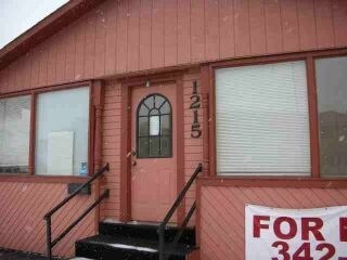
1215 Mount Rushmore Rd, Rapid City, SD 57701


NEARBY LISTINGS FOR SALE OR LEASE
Property Detail
1215 Mount Rushmore Rd
Rapid City, SD
Boulevard Add
0020833
BOULEVARD ADD, BLOCK 35, N50' OF E20' OF LOT 29 & N50' OF LOT 30
Officebuilding
Pennington
X
South Dakota
46103C0778H
29-30
2024
0.07 AC
2025
Rapid City
010800
Other Market Areas
884 SF
DEMOGRAPHICS near 1215 Mount Rushmore Rd
1 Mile
3 Mile
5 Mile
2024 Total Population
9,485
56,808
87,302
2029 Population
10,572
63,350
97,386
Pop Growth 2024-2029
+ 11.46%
+ 11.52%
+ 11.55%
Average Age
40
41
41
2024 Total Households
4,087
24,267
36,542
HH Growth 2024-2029
+ 12.04%
+ 11.91%
+ 11.91%
Median Household Inc
$41,524
$53,707
$61,322
Avg Household Size
1.90
2.10
2.20
2024 Avg HH Vehicles
2.00
2.00
2.00
Median Home Value
$238,574
$234,022
$254,310
Median Year Built
1956
1976
1981
Nearby Places
Map Layers
Map Styles
 Street
 Aerial
- Restaurants
- Banks
- Shops
- Fitness
- Groceries
PUBLIC TRANSPORTATION
AIRPORT
Rapid City Regional
DRIVE
WALK
Distance
Rapid City Regional
20 min
10.9 mi
Freight Ports
Tulsa Port Of Catoosa
DRIVE
WALK
Distance
Tulsa Port Of Catoosa
970 min
891.2 mi
SALE & LEASE HISTORY
LISTING DATE
SALE/LEASE

Nov 11, 2019
For Sale
Nearby Properties
Address
Land Use
TOTAL SIZE
Lot Size
Zoning
Address
Land Use
TOTAL SIZE
Lot Size
Zoning
5,244 SF
17.53 AC
Address
Land Use
TOTAL SIZE
Lot Size
Zoning
40,853 SF
8.09 AC
Address
Land Use
TOTAL SIZE
Lot Size
Zoning
19,728 SF
7.67 AC
Address
Land Use
TOTAL SIZE
Lot Size
Zoning
6,480 SF
11.58 AC
Address
Land Use
TOTAL SIZE
Lot Size
Zoning
5,448 SF
8 AC
Address
Land Use
TOTAL SIZE
Lot Size
Zoning
14,484 SF
5.20 AC
Address
Land Use
TOTAL SIZE
Lot Size
Zoning
3,703 SF
8.46 AC
Address
Land Use
TOTAL SIZE
Lot Size
Zoning
12,258 SF
7.62 AC
Address
Land Use
TOTAL SIZE
Lot Size
Zoning
4,005 SF
12.09 AC
Address
Land Use
TOTAL SIZE
Lot Size
Zoning
48,204 SF
15.19 AC
Address
Land Use
TOTAL SIZE
Lot Size
Zoning
6,820 SF
10.60 AC
Address
Land Use
TOTAL SIZE
Lot Size
Zoning
188,360 SF
37.53 AC
Address
Land Use
TOTAL SIZE
Lot Size
Zoning
8,764 SF
6 AC
Address
Land Use
TOTAL SIZE
Lot Size
Zoning
2,058 SF
6.70 AC
Address
Land Use
TOTAL SIZE
Lot Size
Zoning
48,108 SF
38.14 AC
Address
Land Use
TOTAL SIZE
Lot Size
Zoning
26,807 SF
0.58 AC
Address
Land Use
TOTAL SIZE
Lot Size
Zoning
29,226 SF
1.38 AC
Address
Land Use
TOTAL SIZE
Lot Size
Zoning
14,360 SF
2.07 AC
Address
Land Use
TOTAL SIZE
Lot Size
Zoning
28,584 SF
5.62 AC
Address
Land Use
TOTAL SIZE
Lot Size
Zoning
25,762 SF
5.74 AC
Address
Land Use
TOTAL SIZE
Lot Size
Zoning
62,209 SF
14.15 AC
Address
Land Use
TOTAL SIZE
Lot Size
Zoning
10,608 SF
10.90 AC
Address
Land Use
TOTAL SIZE
Lot Size
Zoning
50,656 SF
9.17 AC
Address
Land Use
TOTAL SIZE
Lot Size
Zoning
147,325 SF
11.93 AC
Address
Land Use
TOTAL SIZE
Lot Size
Zoning
4,576 SF
4.85 AC
Address
Land Use
TOTAL SIZE
Lot Size
Zoning
162,960 SF
22.56 AC
Address
Land Use
TOTAL SIZE
Lot Size
Zoning
26,845 SF
3.49 AC
Address
Land Use
TOTAL SIZE
Lot Size
Zoning
227,112 SF
21.01 AC
Address
Land Use
TOTAL SIZE
Lot Size
Zoning
17,392 SF
7.85 AC
Address
Land Use
TOTAL SIZE
Lot Size
Zoning
164,294 SF
19 AC
The World's #1 Commercial Real Estate Marketplace
Connect with us
© 2025 CoStar Group
The information above has been obtained from sources believed reliable. While we do not doubt its accuracy we have not verified it and make no guarantee, warranty or representation about it. It is your responsibility to independently confirm its accuracy and completeness. Any projections, opinions, assumptions, or estimates used are for example only and do not represent the current or future performance of the property. The value of this transaction to you depends on tax and other factors which should be evaluated by your tax, financial, and legal advisors. You and your advisors should conduct a careful, independent investigation of the property to determine to your satisfaction the suitability of the property for your needs.