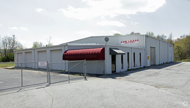
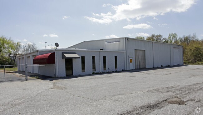
Property Record
1215 Ne Main St, Simpsonville, SC 29681
NEARBY LISTINGS FOR SALE OR LEASE
Property Detail
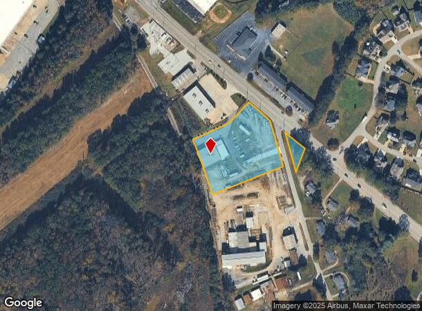
1215 Ne Main St
Greenville-Anderson-Mauldin, SC
Survey For A Glenn Hall Sr
0334.00-01-003.00
MAP 0334.00
Autorepair
Greenville
X
South Carolina
45045C0503E
003.00
2025
4.15 AC
2024
I-385/Simpsonville
003005
Greenville/Spartanburg
2,842 SF
DEMOGRAPHICS near 1215 Ne Main St
1 Mile
3 Mile
5 Mile
2024 Total Population
2,784
37,799
74,336
2029 Population
3,060
41,442
81,549
Pop Growth 2024-2029
+ 9.91%
+ 9.64%
+ 9.70%
Average Age
39
39
39
2024 Total Households
1,089
14,323
27,857
HH Growth 2024-2029
+ 9.83%
+ 9.70%
+ 9.75%
Median Household Inc
$68,053
$81,643
$87,598
Avg Household Size
2.50
2.60
2.60
2024 Avg HH Vehicles
2.00
2.00
2.00
Median Home Value
$236,245
$244,935
$257,496
Median Year Built
1995
1997
1999
Nearby Places
Map Layers
Map Styles
 Street
 Aerial
- Restaurants
- Banks
- Shops
- Fitness
- Groceries
PUBLIC TRANSPORTATION
AIRPORT
Greenville Spartanburg International
DRIVE
WALK
Distance
Greenville Spartanburg International
26 min
18.4 mi
Freight Ports
North Charleston Terminal
DRIVE
WALK
Distance
North Charleston Terminal
211 min
188.6 mi
SALE & LEASE HISTORY
LISTING DATE
SALE/LEASE

Sep 23, 2016
For Sale
Nearby Properties
Address
Land Use
TOTAL SIZE
Lot Size
Zoning
Address
Land Use
TOTAL SIZE
Lot Size
Zoning
40.61 AC
I1
Address
Land Use
TOTAL SIZE
Lot Size
Zoning
Address
Land Use
TOTAL SIZE
Lot Size
Zoning
21.78 AC
I1
Address
Land Use
TOTAL SIZE
Lot Size
Zoning
25.87 AC
I1
Address
Land Use
TOTAL SIZE
Lot Size
Zoning
15.05 AC
I1
Address
Land Use
TOTAL SIZE
Lot Size
Zoning
12.05 AC
RS
Address
Land Use
TOTAL SIZE
Lot Size
Zoning
63.14 AC
I1
Address
Land Use
TOTAL SIZE
Lot Size
Zoning
47.12 AC
RRROW
Address
Land Use
TOTAL SIZE
Lot Size
Zoning
31.37 AC
I1
Address
Land Use
TOTAL SIZE
Lot Size
Zoning
12.73 AC
I1
Address
Land Use
TOTAL SIZE
Lot Size
Zoning
1,158 SF
5.11 AC
I1
Address
Land Use
TOTAL SIZE
Lot Size
Zoning
15.59 AC
I1
Address
Land Use
TOTAL SIZE
Lot Size
Zoning
76.20 AC
R20
Address
Land Use
TOTAL SIZE
Lot Size
Zoning
10.04 AC
BG
Address
Land Use
TOTAL SIZE
Lot Size
Zoning
22.60 AC
R12
Address
Land Use
TOTAL SIZE
Lot Size
Zoning
7.03 AC
I1
Address
Land Use
TOTAL SIZE
Lot Size
Zoning
14.60 AC
I1
Address
Land Use
TOTAL SIZE
Lot Size
Zoning
191 SF
98.20 AC
I1
Address
Land Use
TOTAL SIZE
Lot Size
Zoning
29.96 AC
I1
Address
Land Use
TOTAL SIZE
Lot Size
Zoning
2,249 SF
12.98 AC
C2
Address
Land Use
TOTAL SIZE
Lot Size
Zoning
12.31 AC
I1
Address
Land Use
TOTAL SIZE
Lot Size
Zoning
10.50 AC
RRROW
Address
Land Use
TOTAL SIZE
Lot Size
Zoning
101.18 AC
Address
Land Use
TOTAL SIZE
Lot Size
Zoning
9.89 AC
C2
Address
Land Use
TOTAL SIZE
Lot Size
Zoning
12.11 AC
BG
Address
Land Use
TOTAL SIZE
Lot Size
Zoning
820 SF
6.75 AC
S1
Address
Land Use
TOTAL SIZE
Lot Size
Zoning
1,528 SF
22.81 AC
RM14
Address
Land Use
TOTAL SIZE
Lot Size
Zoning
The World's #1 Commercial Real Estate Marketplace
Connect with us
© 2025 CoStar Group
The information above has been obtained from sources believed reliable. While we do not doubt its accuracy we have not verified it and make no guarantee, warranty or representation about it. It is your responsibility to independently confirm its accuracy and completeness. Any projections, opinions, assumptions, or estimates used are for example only and do not represent the current or future performance of the property. The value of this transaction to you depends on tax and other factors which should be evaluated by your tax, financial, and legal advisors. You and your advisors should conduct a careful, independent investigation of the property to determine to your satisfaction the suitability of the property for your needs.