Property Record
1215 Spotsylvania St, New Athens, IL 62264

NEARBY LISTINGS FOR SALE OR LEASE
-
-
View all New Athens listings for sale on LoopNet.com
Property Detail
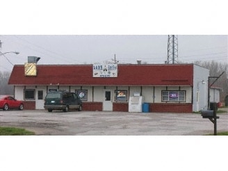
1215 Spotsylvania St
St. Louis, MO-IL
Hanfts, Wm, 2Nd Sub
18-34.0-112-030
HANFTS, WM, 2ND SUB -BLK/RG-10 PT BLK 10 A02179750
Commercialnec
St. Clair
2024
Illinois
2024
1 AC
504001
Outer Metro Illinois
6,040 SF
St. Louis
DEMOGRAPHICS near 1215 Spotsylvania St
1 Mile
3 Mile
5 Mile
2024 Total Population
1,898
2,406
3,486
2029 Population
1,839
2,328
3,377
Pop Growth 2024-2029
(3.11%)
(3.24%)
(3.13%)
Average Age
43
43
43
2024 Total Households
773
973
1,400
HH Growth 2024-2029
(2.98%)
(3.08%)
(3.07%)
Median Household Inc
$83,282
$82,019
$80,232
Avg Household Size
2.40
2.40
2.50
2024 Avg HH Vehicles
2.00
2.00
2.00
Median Home Value
$155,038
$162,824
$171,579
Median Year Built
1961
1960
1961
Nearby Places
Map Layers
Map Styles
 Street
 Aerial
- Restaurants
- Banks
- Shops
- Fitness
- Groceries
PUBLIC TRANSPORTATION
AIRPORT
Scott AFB/Midamerica St Louis
DRIVE
WALK
Distance
Scott AFB/Midamerica St Louis
47 min
24.8 mi
St Louis Lambert International
DRIVE
WALK
Distance
St Louis Lambert International
67 min
45.8 mi
Nearby Properties
Address
Land Use
TOTAL SIZE
Lot Size
Zoning
Address
Land Use
TOTAL SIZE
Lot Size
Zoning
18,139 SF
1.01 AC
Address
Land Use
TOTAL SIZE
Lot Size
Zoning
1,304 SF
1.45 AC
Address
Land Use
TOTAL SIZE
Lot Size
Zoning
6,262 SF
4.58 AC
Address
Land Use
TOTAL SIZE
Lot Size
Zoning
9,552 SF
1.42 AC
Address
Land Use
TOTAL SIZE
Lot Size
Zoning
3,192 SF
1.32 AC
Address
Land Use
TOTAL SIZE
Lot Size
Zoning
2,788 SF
0.77 AC
Address
Land Use
TOTAL SIZE
Lot Size
Zoning
38,398 SF
13.97 AC
Address
Land Use
TOTAL SIZE
Lot Size
Zoning
5.30 AC
Address
Land Use
TOTAL SIZE
Lot Size
Zoning
20,982 SF
0.42 AC
Address
Land Use
TOTAL SIZE
Lot Size
Zoning
Address
Land Use
TOTAL SIZE
Lot Size
Zoning
1,920 SF
2.94 AC
Address
Land Use
TOTAL SIZE
Lot Size
Zoning
17,964 SF
9.77 AC
Address
Land Use
TOTAL SIZE
Lot Size
Zoning
29,085 SF
3.85 AC
Address
Land Use
TOTAL SIZE
Lot Size
Zoning
4,000 SF
0.88 AC
Address
Land Use
TOTAL SIZE
Lot Size
Zoning
54.74 AC
Address
Land Use
TOTAL SIZE
Lot Size
Zoning
7,456 SF
1.30 AC
Address
Land Use
TOTAL SIZE
Lot Size
Zoning
3,330 SF
0.92 AC
Address
Land Use
TOTAL SIZE
Lot Size
Zoning
4,111 SF
0.20 AC
Address
Land Use
TOTAL SIZE
Lot Size
Zoning
55.13 AC
Address
Land Use
TOTAL SIZE
Lot Size
Zoning
3,416 SF
0.81 AC
Address
Land Use
TOTAL SIZE
Lot Size
Zoning
2,200 SF
2.25 AC
Address
Land Use
TOTAL SIZE
Lot Size
Zoning
0.20 AC
Address
Land Use
TOTAL SIZE
Lot Size
Zoning
55.61 AC
Address
Land Use
TOTAL SIZE
Lot Size
Zoning
1,040 SF
0.45 AC
Address
Land Use
TOTAL SIZE
Lot Size
Zoning
1,920 SF
0.20 AC
Address
Land Use
TOTAL SIZE
Lot Size
Zoning
26.76 AC
Address
Land Use
TOTAL SIZE
Lot Size
Zoning
1,888 SF
0.72 AC
Address
Land Use
TOTAL SIZE
Lot Size
Zoning
5,913 SF
0.16 AC
Address
Land Use
TOTAL SIZE
Lot Size
Zoning
226.30 AC
The World's #1 Commercial Real Estate Marketplace
Connect with us
© 2025 CoStar Group
The information above has been obtained from sources believed reliable. While we do not doubt its accuracy we have not verified it and make no guarantee, warranty or representation about it. It is your responsibility to independently confirm its accuracy and completeness. Any projections, opinions, assumptions, or estimates used are for example only and do not represent the current or future performance of the property. The value of this transaction to you depends on tax and other factors which should be evaluated by your tax, financial, and legal advisors. You and your advisors should conduct a careful, independent investigation of the property to determine to your satisfaction the suitability of the property for your needs.