Property Record
1215 Undetermined Dr, Benton City, WA 99320
NEARBY LISTINGS FOR SALE OR LEASE
-
-
View all Benton City listings for sale on LoopNet.com
Property Detail
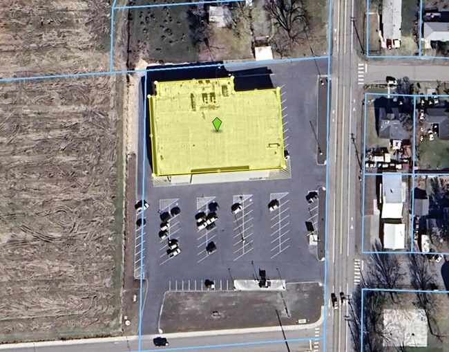
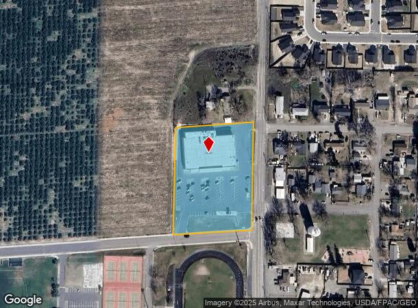
1215 Undetermined Dr
Kennewick-Richland, WA
SECTION 12 - TOWNSHIP 9 NORTH - RANGE 26 NORTH 443.25 FEET OF THE NORTHEAST QUARTER OF THE SOUTHEAST QUARTER TOGETHER WITH EASEMENTS LESS THE WEST 981 FEET THEREOF PUBLIC UTILITY DISTRICT EASEMENT OVER EAST 12 12551. LESS THE SOUTH 20 FEET FOR
112964000001000
Benton
Supermarket
Washington
2024
3.35 AC
2024
Yakima/Kennewick
0119003008
Other Market Areas
28,351 SF
DEMOGRAPHICS near 1215 Undetermined Dr
1 Mile
3 Mile
5 Mile
2024 Total Population
2,786
7,696
9,747
2029 Population
3,113
8,603
10,977
Pop Growth 2024-2029
+ 11.74%
+ 11.79%
+ 12.62%
Average Age
38
40
40
2024 Total Households
950
2,797
3,552
HH Growth 2024-2029
+ 11.68%
+ 11.80%
+ 12.70%
Median Household Inc
$57,847
$64,806
$71,060
Avg Household Size
2.90
2.70
2.70
2024 Avg HH Vehicles
3.00
3.00
3.00
Median Home Value
$242,539
$319,308
$346,232
Median Year Built
1976
1986
1990
Nearby Places
Map Layers
Map Styles
 Street
 Aerial
- Restaurants
- Banks
- Shops
- Fitness
- Groceries
PUBLIC TRANSPORTATION
AIRPORT
Tri-Cities
DRIVE
WALK
Distance
Tri-Cities
32 min
22.2 mi
Nearby Properties
Address
Land Use
TOTAL SIZE
Lot Size
Zoning
Address
Land Use
TOTAL SIZE
Lot Size
Zoning
94,982 SF
26 AC
Address
Land Use
TOTAL SIZE
Lot Size
Zoning
101,649 SF
10.57 AC
Address
Land Use
TOTAL SIZE
Lot Size
Zoning
924 SF
Address
Land Use
TOTAL SIZE
Lot Size
Zoning
273.70 AC
G.M.A. AGR
Address
Land Use
TOTAL SIZE
Lot Size
Zoning
45,193 SF
6.38 AC
Address
Land Use
TOTAL SIZE
Lot Size
Zoning
110 AC
G.M.A. AGR
Address
Land Use
TOTAL SIZE
Lot Size
Zoning
9,376 SF
1.40 AC
Address
Land Use
TOTAL SIZE
Lot Size
Zoning
36,579 SF
74.77 AC
Address
Land Use
TOTAL SIZE
Lot Size
Zoning
29,161 SF
48.22 AC
G.M.A. AGR
Address
Land Use
TOTAL SIZE
Lot Size
Zoning
24,392 SF
8.08 AC
Address
Land Use
TOTAL SIZE
Lot Size
Zoning
26,200 SF
4.93 AC
Address
Land Use
TOTAL SIZE
Lot Size
Zoning
5,883 SF
Address
Land Use
TOTAL SIZE
Lot Size
Zoning
18,180 SF
3.53 AC
Address
Land Use
TOTAL SIZE
Lot Size
Zoning
Address
Land Use
TOTAL SIZE
Lot Size
Zoning
41.71 AC
Address
Land Use
TOTAL SIZE
Lot Size
Zoning
20,190 SF
2.60 AC
Address
Land Use
TOTAL SIZE
Lot Size
Zoning
14,240 SF
4.55 AC
Address
Land Use
TOTAL SIZE
Lot Size
Zoning
33,141 SF
3.81 AC
Address
Land Use
TOTAL SIZE
Lot Size
Zoning
31.80 AC
D2
Address
Land Use
TOTAL SIZE
Lot Size
Zoning
102.70 AC
G.M.A. AGR
Address
Land Use
TOTAL SIZE
Lot Size
Zoning
39.96 AC
G.M.A. AGR
Address
Land Use
TOTAL SIZE
Lot Size
Zoning
11,424 SF
2.88 AC
RURAL LAND
Address
Land Use
TOTAL SIZE
Lot Size
Zoning
10,718 SF
21.69 AC
Address
Land Use
TOTAL SIZE
Lot Size
Zoning
20,974 SF
2.08 AC
Address
Land Use
TOTAL SIZE
Lot Size
Zoning
25.07 AC
G.M.A. AGR
Address
Land Use
TOTAL SIZE
Lot Size
Zoning
4,704 SF
40 AC
G.M.A. AGR
Address
Land Use
TOTAL SIZE
Lot Size
Zoning
24.31 AC
G.M.A. AGR
Address
Land Use
TOTAL SIZE
Lot Size
Zoning
123.57 AC
G.M.A. AGR
Address
Land Use
TOTAL SIZE
Lot Size
Zoning
14,806 SF
2.30 AC
Address
Land Use
TOTAL SIZE
Lot Size
Zoning
16,186 SF
2.96 AC
The World's #1 Commercial Real Estate Marketplace
Connect with us
© 2026 CoStar Group
The information above has been obtained from sources believed reliable. While we do not doubt its accuracy we have not verified it and make no guarantee, warranty or representation about it. It is your responsibility to independently confirm its accuracy and completeness. Any projections, opinions, assumptions, or estimates used are for example only and do not represent the current or future performance of the property. The value of this transaction to you depends on tax and other factors which should be evaluated by your tax, financial, and legal advisors. You and your advisors should conduct a careful, independent investigation of the property to determine to your satisfaction the suitability of the property for your needs.