Property Record
12152 S 119Th & Plainfield Naperville Rd, Plainfield, IL 60585
Current Lease Availabilities
NEARBY LISTINGS FOR SALE OR LEASE
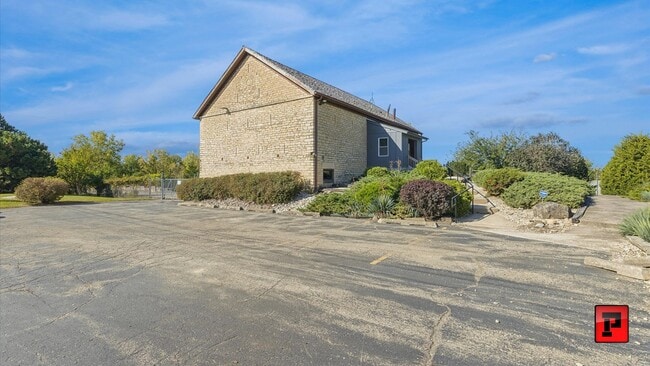
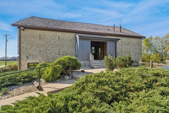
Property Detail
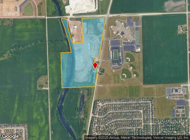
12152 S 119Th & Plainfield Naperville Rd
Chicago-Naperville-Elgin, IL-IN-WI
Industrial
07-01-26-100-010
TRACT 2: THE E1/2 OF THE NW1/4 OF SEC. 26, T37N-R9E, (EXCEPTING THRFRM THAT PRT OF THE E1/2 OF THE NW1/4 LYING E OF THE W'LY
Officebuilding
Will
AE
Illinois
17197C0045G
2
2024
60.47 AC
2024
Joliet/Central Will
880321
Chicago
DEMOGRAPHICS near 12152 S 119Th & Plainfield Naperville Rd
1 Mile
3 Mile
5 Mile
2024 Total Population
4,308
60,749
181,843
2029 Population
4,528
61,853
184,932
Pop Growth 2024-2029
+ 5.11%
+ 1.82%
+ 1.70%
Average Age
37
39
39
2024 Total Households
1,238
19,137
58,315
HH Growth 2024-2029
+ 4.93%
+ 1.84%
+ 1.74%
Median Household Inc
$149,483
$144,062
$131,503
Avg Household Size
3.40
3.10
3.10
2024 Avg HH Vehicles
2.00
2.00
2.00
Median Home Value
$479,176
$426,171
$383,960
Median Year Built
2009
1999
1998
Nearby Places
- Restaurants
- Banks
- Shops
- Fitness
- Groceries
PUBLIC TRANSPORTATION
COMMUTER RAIL
Romeoville (Heritage Corridor - Metra)
DRIVE
WALK
Distance
Romeoville (Heritage Corridor - Metra)
19 min
9.2 mi
AIRPORT
Chicago Midway International
DRIVE
WALK
Distance
Chicago Midway International
38 min
26.5 mi
Chicago O'Hare International
DRIVE
WALK
Distance
Chicago O'Hare International
55 min
37.9 mi
Freight Ports
Port Milwaukee
DRIVE
WALK
Distance
Port Milwaukee
136 min
109.6 mi
Nearby Properties
Address
Land Use
TOTAL SIZE
Lot Size
Zoning
Address
Land Use
TOTAL SIZE
Lot Size
Zoning
952,135 SF
21.86 AC
Address
Land Use
TOTAL SIZE
Lot Size
Zoning
747,420 SF
49.43 AC
Address
Land Use
TOTAL SIZE
Lot Size
Zoning
13.71 AC
Address
Land Use
TOTAL SIZE
Lot Size
Zoning
800,000 SF
43.13 AC
Address
Land Use
TOTAL SIZE
Lot Size
Zoning
715,638 SF
35.12 AC
Address
Land Use
TOTAL SIZE
Lot Size
Zoning
172,838 SF
14.76 AC
Address
Land Use
TOTAL SIZE
Lot Size
Zoning
615,239 SF
33.44 AC
Address
Land Use
TOTAL SIZE
Lot Size
Zoning
660,649 SF
29.66 AC
Address
Land Use
TOTAL SIZE
Lot Size
Zoning
23.85 AC
Address
Land Use
TOTAL SIZE
Lot Size
Zoning
649,933 SF
31.18 AC
Address
Land Use
TOTAL SIZE
Lot Size
Zoning
Address
Land Use
TOTAL SIZE
Lot Size
Zoning
965,899 SF
22.17 AC
Address
Land Use
TOTAL SIZE
Lot Size
Zoning
33.74 AC
Address
Land Use
TOTAL SIZE
Lot Size
Zoning
14.59 AC
Address
Land Use
TOTAL SIZE
Lot Size
Zoning
405,099 SF
23.77 AC
Address
Land Use
TOTAL SIZE
Lot Size
Zoning
155,114 SF
14.61 AC
Address
Land Use
TOTAL SIZE
Lot Size
Zoning
17.81 AC
Address
Land Use
TOTAL SIZE
Lot Size
Zoning
355,535 SF
23.47 AC
Address
Land Use
TOTAL SIZE
Lot Size
Zoning
448,352 SF
15.67 AC
Address
Land Use
TOTAL SIZE
Lot Size
Zoning
14.26 AC
Address
Land Use
TOTAL SIZE
Lot Size
Zoning
12.68 AC
Address
Land Use
TOTAL SIZE
Lot Size
Zoning
12.85 AC
Address
Land Use
TOTAL SIZE
Lot Size
Zoning
328,656 SF
16.35 AC
Address
Land Use
TOTAL SIZE
Lot Size
Zoning
112,629 SF
11.13 AC
Address
Land Use
TOTAL SIZE
Lot Size
Zoning
30.80 AC
Address
Land Use
TOTAL SIZE
Lot Size
Zoning
23.79 AC
Address
Land Use
TOTAL SIZE
Lot Size
Zoning
313,312 SF
17.10 AC
Address
Land Use
TOTAL SIZE
Lot Size
Zoning
5.49 AC
Address
Land Use
TOTAL SIZE
Lot Size
Zoning
232,964 SF
28.66 AC
Address
Land Use
TOTAL SIZE
Lot Size
Zoning
260,860 SF
13.80 AC
The World's #1 Commercial Real Estate Marketplace
Connect with us
© 2025 CoStar Group
The information above has been obtained from sources believed reliable. While we do not doubt its accuracy we have not verified it and make no guarantee, warranty or representation about it. It is your responsibility to independently confirm its accuracy and completeness. Any projections, opinions, assumptions, or estimates used are for example only and do not represent the current or future performance of the property. The value of this transaction to you depends on tax and other factors which should be evaluated by your tax, financial, and legal advisors. You and your advisors should conduct a careful, independent investigation of the property to determine to your satisfaction the suitability of the property for your needs.