Property Record
12153 Moline St, Commerce City, CO 80640
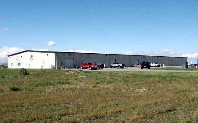

Property Detail
12153 Moline St
Denver-Aurora-Centennial, CO
SUB:SHIRABA PARK SUBDIVISION LOT:1
1571-35-4-01-001
ADAMS
Warehouse
Colorado
B and X Area of moderate flood hazard, usually the area between the limits of the 100-year and 500-year floods.
1
2024
5.79 AC
2025
DIA
008557
Denver
30,000 SF
NEARBY LISTINGS FOR SALE OR LEASE
DEMOGRAPHICS near 12153 Moline St
1 mile
3 mile
5 mile
2024 Total Population
6,895
31,352
114,848
2029 Population
7,082
33,096
120,372
Pop Growth 2024-2029
+ 2.71%
+ 5.56%
+ 4.81%
Average Age
35
35
36
2024 Total Households
2,075
9,781
37,294
HH Growth 2024-2029
+ 3.04%
+ 5.85%
+ 5.10%
Median Household Inc
$125,469
$134,105
$125,099
Avg Household Size
3.30
3.20
3.00
2024 Avg HH Vehicles
2.00
2.00
2.00
Median Home Value
$542,559
$593,259
$581,242
Median Year Built
2005
2007
2004
Nearby Places
Map Layers
Map Styles
 Street
 Aerial
Transit
 Traffic
 Biking
Places
Listings with unknown addresses are not visible on the map
- Restaurants
- Banks
- Shops
- Fitness
- Groceries
PUBLIC TRANSPORTATION
COMMUTER RAIL
Thornton Crossroads - 104Th Station Track 1 (Union Station to Eastlake & 124th Station - Regional Transportation District)
Drive
Walk
Distance
Thornton Crossroads - 104Th Station Track 1 (Union Station to Eastlake & 124th Station - Regional Transportation District)
11 min
6.2 mi
Northglenn - 112Th Station Track 2 (Union Station to Eastlake & 124th Station - Regional Transportation District)
Drive
Walk
Distance
Northglenn - 112Th Station Track 2 (Union Station to Eastlake & 124th Station - Regional Transportation District)
12 min
6.6 mi
AIRPORT
Denver International
Drive
Walk
Distance
Denver International
23 min
16.1 mi
Freight Ports
Tulsa Port Of Catoosa
Drive
Walk
Distance
Tulsa Port Of Catoosa
730 min
710.2 mi
Nearby Properties
Address
Land Use
TOTAL SIZE
Lot Size
Zoning
Address
Land Use
TOTAL SIZE
Lot Size
Zoning
279,946 SF
11.55 AC
Address
Land Use
TOTAL SIZE
Lot Size
Zoning
8,556 SF
382.73 AC
A3
Address
Land Use
TOTAL SIZE
Lot Size
Zoning
358,386 SF
76.08 AC
Address
Land Use
TOTAL SIZE
Lot Size
Zoning
276,395 SF
26.43 AC
A3
Address
Land Use
TOTAL SIZE
Lot Size
Zoning
330,176 SF
17.12 AC
Address
Land Use
TOTAL SIZE
Lot Size
Zoning
298,200 SF
17.67 AC
Address
Land Use
TOTAL SIZE
Lot Size
Zoning
272,800 SF
16.44 AC
Address
Land Use
TOTAL SIZE
Lot Size
Zoning
64,750 SF
11.91 AC
Address
Land Use
TOTAL SIZE
Lot Size
Zoning
158,001 SF
20.40 AC
Address
Land Use
TOTAL SIZE
Lot Size
Zoning
Address
Land Use
TOTAL SIZE
Lot Size
Zoning
96,628 SF
4.35 AC
Address
Land Use
TOTAL SIZE
Lot Size
Zoning
174.45 AC
Address
Land Use
TOTAL SIZE
Lot Size
Zoning
207,453 SF
26.66 AC
Address
Land Use
TOTAL SIZE
Lot Size
Zoning
121,275 SF
6.56 AC
Address
Land Use
TOTAL SIZE
Lot Size
Zoning
48,359 SF
278.79 AC
A3
Address
Land Use
TOTAL SIZE
Lot Size
Zoning
64,715 SF
10.38 AC
Address
Land Use
TOTAL SIZE
Lot Size
Zoning
106,530 SF
7.04 AC
Address
Land Use
TOTAL SIZE
Lot Size
Zoning
70,573 SF
6.42 AC
Address
Land Use
TOTAL SIZE
Lot Size
Zoning
63,989 SF
12.74 AC
Address
Land Use
TOTAL SIZE
Lot Size
Zoning
122,399 SF
14.29 AC
Address
Land Use
TOTAL SIZE
Lot Size
Zoning
89,219 SF
11.79 AC
Address
Land Use
TOTAL SIZE
Lot Size
Zoning
55,810 SF
14.52 AC
Address
Land Use
TOTAL SIZE
Lot Size
Zoning
82,239 SF
7.02 AC
Address
Land Use
TOTAL SIZE
Lot Size
Zoning
79,121 SF
6.39 AC
Address
Land Use
TOTAL SIZE
Lot Size
Zoning
19,341 SF
74.46 AC
Address
Land Use
TOTAL SIZE
Lot Size
Zoning
75,398 SF
8.82 AC
I2
Address
Land Use
TOTAL SIZE
Lot Size
Zoning
106.69 AC
RE
Address
Land Use
TOTAL SIZE
Lot Size
Zoning
102,069 SF
3.26 AC
Address
Land Use
TOTAL SIZE
Lot Size
Zoning
44,215 SF
21.32 AC
Address
Land Use
TOTAL SIZE
Lot Size
Zoning
22,594 SF
19.96 AC
The World's #1 Commercial Real Estate Marketplace
Connect with us
© 2026 CoStar Group
The information above has been obtained from sources believed reliable. While we do not doubt its accuracy we have not verified it and make no guarantee, warranty or representation about it. It is your responsibility to independently confirm its accuracy and completeness. Any projections, opinions, assumptions, or estimates used are for example only and do not represent the current or future performance of the property. The value of this transaction to you depends on tax and other factors which should be evaluated by your tax, financial, and legal advisors. You and your advisors should conduct a careful, independent investigation of the property to determine to your satisfaction the suitability of the property for your needs.