Property Record
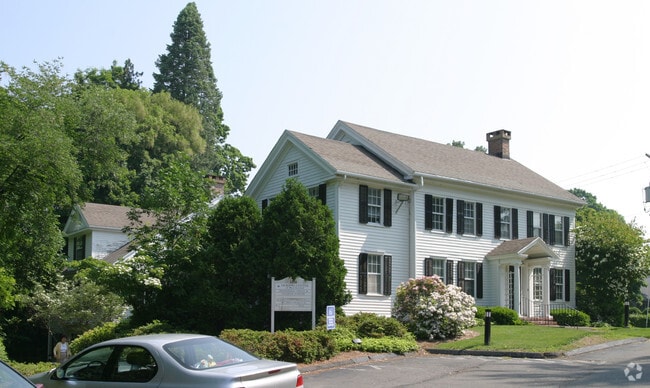
1216 Farmington Ave, West Hartford, CT 06107


This Property Is For Sale
NEARBY LISTINGS FOR SALE OR LEASE
Property Detail
1216 Farmington Ave
WHAR-000010D-001891-001216
Hartford
Commercialbuilding
Connecticut
AE
1216
09003C0344F
3.47 AC
2025
West Hartford
2025
Hartford
497700
Hartford-West Hartford-East Hartford, CT
11,345 SF
DEMOGRAPHICS near 1216 Farmington Ave
1 Mile
3 Mile
5 Mile
2024 Total Population
8,848
72,728
230,401
2029 Population
8,781
72,141
229,224
Pop Growth 2024-2029
(0.76%)
(0.81%)
(0.51%)
Average Age
42
41
39
2024 Total Households
3,399
30,171
92,069
HH Growth 2024-2029
(0.82%)
(0.89%)
(0.40%)
Median Household Inc
$162,561
$103,943
$65,926
Avg Household Size
2.50
2.30
2.30
2024 Avg HH Vehicles
2.00
2.00
1.00
Median Home Value
$437,970
$357,649
$284,527
Median Year Built
1953
1954
1956
Nearby Places
Map Layers
Map Styles
 Street
 Aerial
- Restaurants
- Banks
- Shops
- Fitness
- Groceries
PUBLIC TRANSPORTATION
COMMUTER RAIL
Hartford (Hartford Line - Hartford Line)
DRIVE
WALK
Distance
Hartford (Hartford Line - Hartford Line)
8 min
4.5 mi
Hartford Amtrak Station (Amtrak Hartford Line - Amtrak, Northeast Regional - Amtrak, Valley Flyer - Amtrak, Vermonter - Amtrak)
DRIVE
WALK
Distance
Hartford Amtrak Station (Amtrak Hartford Line - Amtrak, Northeast Regional - Amtrak, Valley Flyer - Amtrak, Vermonter - Amtrak)
8 min
4.7 mi
AIRPORT
Bradley International
DRIVE
WALK
Distance
Bradley International
40 min
17.9 mi
Freight Ports
Port of New Haven
DRIVE
WALK
Distance
Port of New Haven
52 min
37.6 mi
Nearby Properties
Address
Land Use
TOTAL SIZE
Lot Size
Zoning
Address
Land Use
TOTAL SIZE
Lot Size
Zoning
88.48 AC
R-10
Address
Land Use
TOTAL SIZE
Lot Size
Zoning
3,605 SF
28.33 AC
R-6,RM
Address
Land Use
TOTAL SIZE
Lot Size
Zoning
20.61 AC
R-10,S
Address
Land Use
TOTAL SIZE
Lot Size
Zoning
211,308 SF
55.90 AC
R-13
Address
Land Use
TOTAL SIZE
Lot Size
Zoning
191,718 SF
16 AC
R40
Address
Land Use
TOTAL SIZE
Lot Size
Zoning
9,238 SF
28.35 AC
R-10,R
Address
Land Use
TOTAL SIZE
Lot Size
Zoning
112,975 SF
11.44 AC
RM-3
Address
Land Use
TOTAL SIZE
Lot Size
Zoning
3.41 AC
BC,RP
Address
Land Use
TOTAL SIZE
Lot Size
Zoning
86,600 SF
20.05 AC
R-6
Address
Land Use
TOTAL SIZE
Lot Size
Zoning
15.39 AC
SDD/RM
Address
Land Use
TOTAL SIZE
Lot Size
Zoning
138,582 SF
23.64 AC
BR
Address
Land Use
TOTAL SIZE
Lot Size
Zoning
162,470 SF
27.10 AC
R40
Address
Land Use
TOTAL SIZE
Lot Size
Zoning
16.94 AC
C1
Address
Land Use
TOTAL SIZE
Lot Size
Zoning
215,215 SF
42 AC
R-10,R
Address
Land Use
TOTAL SIZE
Lot Size
Zoning
2.32 AC
SDD/CB
Address
Land Use
TOTAL SIZE
Lot Size
Zoning
8.17 AC
BS,R-1
Address
Land Use
TOTAL SIZE
Lot Size
Zoning
2.84 AC
CBDH
Address
Land Use
TOTAL SIZE
Lot Size
Zoning
8.87 AC
BS,R-1
Address
Land Use
TOTAL SIZE
Lot Size
Zoning
6.34 AC
BS,R-1
Address
Land Use
TOTAL SIZE
Lot Size
Zoning
13.13 AC
SDD/BG
Address
Land Use
TOTAL SIZE
Lot Size
Zoning
215,058 SF
R-6
Address
Land Use
TOTAL SIZE
Lot Size
Zoning
184,831 SF
40 AC
R-13
Address
Land Use
TOTAL SIZE
Lot Size
Zoning
13.43 AC
SDD/BG
Address
Land Use
TOTAL SIZE
Lot Size
Zoning
5.23 AC
MS-1
Address
Land Use
TOTAL SIZE
Lot Size
Zoning
215,058 SF
R-6
Address
Land Use
TOTAL SIZE
Lot Size
Zoning
5.05 AC
R-6,RM
Address
Land Use
TOTAL SIZE
Lot Size
Zoning
146,095 SF
2.08 AC
SDD/CB
Address
Land Use
TOTAL SIZE
Lot Size
Zoning
2.80 AC
N2-1
Address
Land Use
TOTAL SIZE
Lot Size
Zoning
8.87 AC
SDD/BG
Address
Land Use
TOTAL SIZE
Lot Size
Zoning
190,192 SF
8.60 AC
R-10
The World's #1 Commercial Real Estate Marketplace
Connect with us
© 2026 CoStar Group
The information above has been obtained from sources believed reliable. While we do not doubt its accuracy we have not verified it and make no guarantee, warranty or representation about it. It is your responsibility to independently confirm its accuracy and completeness. Any projections, opinions, assumptions, or estimates used are for example only and do not represent the current or future performance of the property. The value of this transaction to you depends on tax and other factors which should be evaluated by your tax, financial, and legal advisors. You and your advisors should conduct a careful, independent investigation of the property to determine to your satisfaction the suitability of the property for your needs.