Property Record
1216 Mccarter Hwy, Newark, NJ 07104
NEARBY LISTINGS FOR SALE OR LEASE
-
-
-
-
-
-
-
-
No Photo
-
View all Newark listings for sale on LoopNet.com
Property Detail
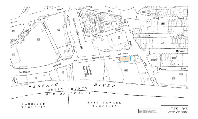
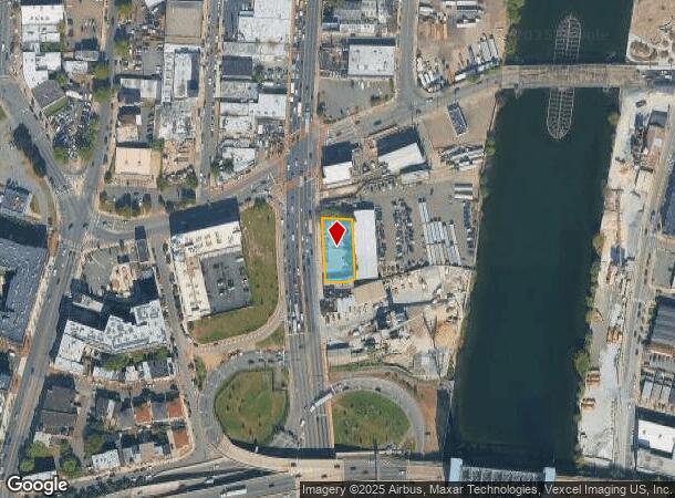
1216 Mccarter Hwy
14-00434-0000-00011
171.9X82.6
Commercialnec
Essex
X
New Jersey
34013C0156F
11
2023
0.33 AC
2025
Newark
022900
Northern New Jersey
1,435 SF
Newark, NJ-PA
DEMOGRAPHICS near 1216 Mccarter Hwy
1 Mile
3 Mile
5 Mile
2024 Total Population
62,005
372,193
735,946
2029 Population
60,058
359,442
712,719
Pop Growth 2024-2029
(3.14%)
(3.43%)
(3.16%)
Average Age
36
37
38
2024 Total Households
22,845
135,792
271,026
HH Growth 2024-2029
(2.71%)
(3.47%)
(3.25%)
Median Household Inc
$56,128
$49,093
$57,799
Avg Household Size
2.40
2.60
2.60
2024 Avg HH Vehicles
1.00
1.00
1.00
Median Home Value
$368,153
$328,631
$353,533
Median Year Built
1971
1964
1958
Nearby Places
Map Layers
Map Styles
 Street
 Aerial
- Restaurants
- Banks
- Shops
- Fitness
- Groceries
PUBLIC TRANSPORTATION
TRANSIT/SUBWAY
Newark-Broad Street (Broad Street Station - Newark Penn Station - Newark Light Rail (Newark Light Rail))
DRIVE
WALK
Distance
Newark-Broad Street (Broad Street Station - Newark Penn Station - Newark Light Rail (Newark Light Rail))
2 min
7 min
0.4 mi
Riverfront Stadium (Broad Street Station - Newark Penn Station - Newark Light Rail (Newark Light Rail))
DRIVE
WALK
Distance
Riverfront Stadium (Broad Street Station - Newark Penn Station - Newark Light Rail (Newark Light Rail))
1 min
7 min
0.4 mi
Atlantic Street (Broad Street Station - Newark Penn Station - Newark Light Rail (Newark Light Rail))
DRIVE
WALK
Distance
Atlantic Street (Broad Street Station - Newark Penn Station - Newark Light Rail (Newark Light Rail))
1 min
9 min
0.5 mi
Washington Park (Broad Street Station - Newark Penn Station - Newark Light Rail (Newark Light Rail))
DRIVE
WALK
Distance
Washington Park (Broad Street Station - Newark Penn Station - Newark Light Rail (Newark Light Rail))
1 min
10 min
0.5 mi
Njpac/Center Street (Broad Street Station - Newark Penn Station - Newark Light Rail (Newark Light Rail))
DRIVE
WALK
Distance
Njpac/Center Street (Broad Street Station - Newark Penn Station - Newark Light Rail (Newark Light Rail))
1 min
15 min
0.7 mi
COMMUTER RAIL
Newark Broad Street (Montclair-Boonton Line - NJ Transit Commuter Rail (NJ Transit), Morris & Essex Gladstone Branch - NJ Transit Commuter Rail (NJ Transit), Morris & Essex Morristown Line - NJ Transit Commuter Rail (NJ Transit))
DRIVE
WALK
Distance
Newark Broad Street (Montclair-Boonton Line - NJ Transit Commuter Rail (NJ Transit), Morris & Essex Gladstone Branch - NJ Transit Commuter Rail (NJ Transit), Morris & Essex Morristown Line - NJ Transit Commuter Rail (NJ Transit))
2 min
6 min
0.4 mi
Harrison (Newark Penn Station-World Trade Center - Port Authority Trans-Hudson (PATH))
DRIVE
WALK
Distance
Harrison (Newark Penn Station-World Trade Center - Port Authority Trans-Hudson (PATH))
3 min
1.5 mi
AIRPORT
Newark Liberty International
DRIVE
WALK
Distance
Newark Liberty International
10 min
6.3 mi
LaGuardia
DRIVE
WALK
Distance
LaGuardia
40 min
26.6 mi
John F Kennedy International
DRIVE
WALK
Distance
John F Kennedy International
49 min
29.4 mi
Freight Ports
Port Newark Container Terminal
DRIVE
WALK
Distance
Port Newark Container Terminal
13 min
6.1 mi
Nearby Properties
Address
Land Use
TOTAL SIZE
Lot Size
Zoning
Address
Land Use
TOTAL SIZE
Lot Size
Zoning
0.57 AC
Address
Land Use
TOTAL SIZE
Lot Size
Zoning
0.45 AC
Address
Land Use
TOTAL SIZE
Lot Size
Zoning
31.86 AC
Address
Land Use
TOTAL SIZE
Lot Size
Zoning
25.69 AC
Address
Land Use
TOTAL SIZE
Lot Size
Zoning
Address
Land Use
TOTAL SIZE
Lot Size
Zoning
877 SF
7.25 AC
Address
Land Use
TOTAL SIZE
Lot Size
Zoning
4.51 AC
Address
Land Use
TOTAL SIZE
Lot Size
Zoning
683 SF
9.59 AC
Address
Land Use
TOTAL SIZE
Lot Size
Zoning
2,500 SF
43.35 AC
Address
Land Use
TOTAL SIZE
Lot Size
Zoning
2.01 AC
Address
Land Use
TOTAL SIZE
Lot Size
Zoning
3.42 AC
Address
Land Use
TOTAL SIZE
Lot Size
Zoning
320 SF
1.25 AC
Address
Land Use
TOTAL SIZE
Lot Size
Zoning
710 SF
39.32 AC
Address
Land Use
TOTAL SIZE
Lot Size
Zoning
9.77 AC
Address
Land Use
TOTAL SIZE
Lot Size
Zoning
877 SF
0.91 AC
Address
Land Use
TOTAL SIZE
Lot Size
Zoning
1.64 AC
Address
Land Use
TOTAL SIZE
Lot Size
Zoning
Address
Land Use
TOTAL SIZE
Lot Size
Zoning
1.63 AC
Address
Land Use
TOTAL SIZE
Lot Size
Zoning
17.97 AC
Address
Land Use
TOTAL SIZE
Lot Size
Zoning
Address
Land Use
TOTAL SIZE
Lot Size
Zoning
2.79 AC
Address
Land Use
TOTAL SIZE
Lot Size
Zoning
4.82 AC
Address
Land Use
TOTAL SIZE
Lot Size
Zoning
0.13 AC
Address
Land Use
TOTAL SIZE
Lot Size
Zoning
1,264 SF
3.20 AC
Address
Land Use
TOTAL SIZE
Lot Size
Zoning
Address
Land Use
TOTAL SIZE
Lot Size
Zoning
0.06 AC
Address
Land Use
TOTAL SIZE
Lot Size
Zoning
0.09 AC
Address
Land Use
TOTAL SIZE
Lot Size
Zoning
877 SF
1.95 AC
Address
Land Use
TOTAL SIZE
Lot Size
Zoning
877 SF
1.35 AC
Address
Land Use
TOTAL SIZE
Lot Size
Zoning
16,084 SF
7.23 AC
The World's #1 Commercial Real Estate Marketplace
Connect with us
© 2025 CoStar Group
The information above has been obtained from sources believed reliable. While we do not doubt its accuracy we have not verified it and make no guarantee, warranty or representation about it. It is your responsibility to independently confirm its accuracy and completeness. Any projections, opinions, assumptions, or estimates used are for example only and do not represent the current or future performance of the property. The value of this transaction to you depends on tax and other factors which should be evaluated by your tax, financial, and legal advisors. You and your advisors should conduct a careful, independent investigation of the property to determine to your satisfaction the suitability of the property for your needs.