Property Record
1216 N Maple Island Rd, Hesperia, MI 49421


NEARBY LISTINGS FOR SALE OR LEASE
-
-
View all Hesperia listings for sale on LoopNet.com
Property Detail
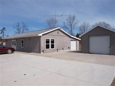
1216 N Maple Island Rd
09-30-100-008
S08t14nr14w
Commercialnec
PART NW1/4 COM AT W1/4 COR, TH N00D 07'00E 217.50 FT, N89D 47'40E 193 FT, S06D 55'50W 219.20 FT TO E & W 1/4 LN
X
Newaygo
26123C0275D
Michigan
2024
0.90 AC
2025
Newaygo County
970300
West Michigan
1,512 SF
DEMOGRAPHICS near 1216 N Maple Island Rd
1 Mile
3 Mile
5 Mile
2024 Total Population
1,232
2,750
4,497
2029 Population
1,263
2,826
4,620
Pop Growth 2024-2029
+ 2.52%
+ 2.76%
+ 2.74%
Average Age
40
41
41
2024 Total Households
457
1,035
1,713
HH Growth 2024-2029
+ 2.19%
+ 2.51%
+ 2.57%
Median Household Inc
$48,097
$48,157
$49,003
Avg Household Size
2.60
2.60
2.60
2024 Avg HH Vehicles
2.00
2.00
2.00
Median Home Value
$109,402
$116,123
$127,309
Median Year Built
1972
1974
1975
Nearby Places
Map Layers
Map Styles
 Street
 Aerial
- Restaurants
- Banks
- Shops
- Fitness
- Groceries
Nearby Properties
Address
Land Use
TOTAL SIZE
Lot Size
Zoning
Address
Land Use
TOTAL SIZE
Lot Size
Zoning
40 AC
LOCAL ZONE
Address
Land Use
TOTAL SIZE
Lot Size
Zoning
3,360 SF
2.65 AC
Address
Land Use
TOTAL SIZE
Lot Size
Zoning
157 AC
LOCAL ZONE
Address
Land Use
TOTAL SIZE
Lot Size
Zoning
100 AC
LOCAL ZONE
Address
Land Use
TOTAL SIZE
Lot Size
Zoning
2.50 AC
Address
Land Use
TOTAL SIZE
Lot Size
Zoning
1.08 AC
Address
Land Use
TOTAL SIZE
Lot Size
Zoning
237.75 AC
LOCAL ZONE
Address
Land Use
TOTAL SIZE
Lot Size
Zoning
192 SF
33.73 AC
LOCAL ZONE
Address
Land Use
TOTAL SIZE
Lot Size
Zoning
9,020 SF
1.04 AC
LOCAL ZONE
Address
Land Use
TOTAL SIZE
Lot Size
Zoning
1,520 SF
35 AC
Address
Land Use
TOTAL SIZE
Lot Size
Zoning
Address
Land Use
TOTAL SIZE
Lot Size
Zoning
17,440 SF
1.33 AC
LOCAL ZONE
Address
Land Use
TOTAL SIZE
Lot Size
Zoning
148.39 AC
Address
Land Use
TOTAL SIZE
Lot Size
Zoning
1,816 SF
4.99 AC
Address
Land Use
TOTAL SIZE
Lot Size
Zoning
154.59 AC
LOCAL ZONE
Address
Land Use
TOTAL SIZE
Lot Size
Zoning
155 AC
Address
Land Use
TOTAL SIZE
Lot Size
Zoning
4,186 SF
0.25 AC
LOCAL ZONE
Address
Land Use
TOTAL SIZE
Lot Size
Zoning
1.07 AC
Address
Land Use
TOTAL SIZE
Lot Size
Zoning
Address
Land Use
TOTAL SIZE
Lot Size
Zoning
16,640 SF
2.38 AC
LOCAL ZONE
Address
Land Use
TOTAL SIZE
Lot Size
Zoning
111.42 AC
Address
Land Use
TOTAL SIZE
Lot Size
Zoning
0.85 AC
Address
Land Use
TOTAL SIZE
Lot Size
Zoning
6,389 SF
0.31 AC
Address
Land Use
TOTAL SIZE
Lot Size
Zoning
2,124 SF
0.52 AC
Address
Land Use
TOTAL SIZE
Lot Size
Zoning
1.05 AC
Address
Land Use
TOTAL SIZE
Lot Size
Zoning
3,150 SF
2.20 AC
LOCAL ZONE
Address
Land Use
TOTAL SIZE
Lot Size
Zoning
Address
Land Use
TOTAL SIZE
Lot Size
Zoning
7,200 SF
0.59 AC
Address
Land Use
TOTAL SIZE
Lot Size
Zoning
3,200 SF
0.75 AC
LOCAL ZONE
Address
Land Use
TOTAL SIZE
Lot Size
Zoning
79.86 AC
LOCAL ZONE
The World's #1 Commercial Real Estate Marketplace
Connect with us
© 2025 CoStar Group
The information above has been obtained from sources believed reliable. While we do not doubt its accuracy we have not verified it and make no guarantee, warranty or representation about it. It is your responsibility to independently confirm its accuracy and completeness. Any projections, opinions, assumptions, or estimates used are for example only and do not represent the current or future performance of the property. The value of this transaction to you depends on tax and other factors which should be evaluated by your tax, financial, and legal advisors. You and your advisors should conduct a careful, independent investigation of the property to determine to your satisfaction the suitability of the property for your needs.