Property Record
12170 Lochridge Blvd, Covington, GA 30014
NEARBY LISTINGS FOR SALE OR LEASE
Property Detail
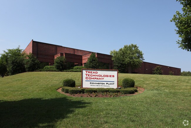
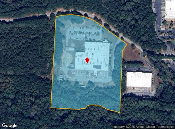
12170 Lochridge Blvd
C081000000027E00
Lochridge Blvd
Manufacturinglight
17.432AC LOCHRIDGE IND BL
A
Newton
13217C0127D
Georgia
2025
17.43 AC
2025
Rockdale/Newton Cnty
100301
Atlanta
91,200 SF
Atlanta-Sandy Springs-Roswell, GA
DEMOGRAPHICS near 12170 Lochridge Blvd
1 Mile
3 Mile
5 Mile
2024 Total Population
1,547
19,148
38,503
2029 Population
1,676
21,397
42,899
Pop Growth 2024-2029
+ 8.34%
+ 11.75%
+ 11.42%
Average Age
35
39
39
2024 Total Households
593
7,142
14,228
HH Growth 2024-2029
+ 8.60%
+ 12.14%
+ 11.77%
Median Household Inc
$44,933
$83,139
$76,935
Avg Household Size
2.60
2.60
2.60
2024 Avg HH Vehicles
2.00
2.00
2.00
Median Home Value
$215,060
$245,285
$210,741
Median Year Built
1994
1994
1992
Nearby Places
Map Layers
Map Styles
 Street
 Aerial
- Restaurants
- Banks
- Shops
- Fitness
- Groceries
Nearby Properties
Address
Land Use
TOTAL SIZE
Lot Size
Zoning
Address
Land Use
TOTAL SIZE
Lot Size
Zoning
8,358 SF
24.01 AC
Address
Land Use
TOTAL SIZE
Lot Size
Zoning
359,785 SF
107 AC
Address
Land Use
TOTAL SIZE
Lot Size
Zoning
207,237 SF
10.61 AC
E1
Address
Land Use
TOTAL SIZE
Lot Size
Zoning
6,664 SF
17.75 AC
Address
Land Use
TOTAL SIZE
Lot Size
Zoning
214,590 SF
39.68 AC
Address
Land Use
TOTAL SIZE
Lot Size
Zoning
498,960 SF
97.46 AC
AR
Address
Land Use
TOTAL SIZE
Lot Size
Zoning
331,492 SF
163.71 AC
I1
Address
Land Use
TOTAL SIZE
Lot Size
Zoning
391,932 SF
73.70 AC
R1
Address
Land Use
TOTAL SIZE
Lot Size
Zoning
793,200 SF
63.82 AC
Address
Land Use
TOTAL SIZE
Lot Size
Zoning
7,130 SF
36.78 AC
A1
Address
Land Use
TOTAL SIZE
Lot Size
Zoning
544,058 SF
96.10 AC
I1
Address
Land Use
TOTAL SIZE
Lot Size
Zoning
676,458 SF
62.36 AC
Address
Land Use
TOTAL SIZE
Lot Size
Zoning
45,900 AC
Address
Land Use
TOTAL SIZE
Lot Size
Zoning
88,944 SF
0.98 AC
E1
Address
Land Use
TOTAL SIZE
Lot Size
Zoning
591,770 SF
37.73 AC
I1
Address
Land Use
TOTAL SIZE
Lot Size
Zoning
140,000 SF
21.91 AC
I1
Address
Land Use
TOTAL SIZE
Lot Size
Zoning
28,884 SF
38.23 AC
C1
Address
Land Use
TOTAL SIZE
Lot Size
Zoning
10,000 SF
0.01 AC
Address
Land Use
TOTAL SIZE
Lot Size
Zoning
262,782 SF
20.94 AC
Address
Land Use
TOTAL SIZE
Lot Size
Zoning
322,560 SF
32.72 AC
Address
Land Use
TOTAL SIZE
Lot Size
Zoning
239,008 SF
54.79 AC
I1
Address
Land Use
TOTAL SIZE
Lot Size
Zoning
1,627 SF
16.62 AC
C1
Address
Land Use
TOTAL SIZE
Lot Size
Zoning
123,360 SF
109.16 AC
I1
Address
Land Use
TOTAL SIZE
Lot Size
Zoning
14,080 SF
10 AC
C1
Address
Land Use
TOTAL SIZE
Lot Size
Zoning
188,699 SF
12.04 AC
Address
Land Use
TOTAL SIZE
Lot Size
Zoning
150,000 SF
34.05 AC
Address
Land Use
TOTAL SIZE
Lot Size
Zoning
154,520 SF
7.98 AC
C1
Address
Land Use
TOTAL SIZE
Lot Size
Zoning
34,384 SF
3.32 AC
Address
Land Use
TOTAL SIZE
Lot Size
Zoning
112,884 SF
2.74 AC
Address
Land Use
TOTAL SIZE
Lot Size
Zoning
50,464 SF
12.11 AC
The World's #1 Commercial Real Estate Marketplace
Connect with us
© 2026 CoStar Group
The information above has been obtained from sources believed reliable. While we do not doubt its accuracy we have not verified it and make no guarantee, warranty or representation about it. It is your responsibility to independently confirm its accuracy and completeness. Any projections, opinions, assumptions, or estimates used are for example only and do not represent the current or future performance of the property. The value of this transaction to you depends on tax and other factors which should be evaluated by your tax, financial, and legal advisors. You and your advisors should conduct a careful, independent investigation of the property to determine to your satisfaction the suitability of the property for your needs.