Property Record
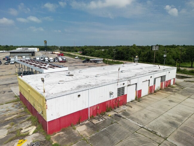
12170 Old Gentilly Rd, New Orleans, LA 70129


Current Lease Availabilities
NEARBY LISTINGS FOR SALE OR LEASE
Property Detail
12170 Old Gentilly Rd
3-9W-8-274-48
Gntly Rdrs
Truckterminal
SQ GENTILLY RD R S DEPTH PTS ARPTS A 172/184 1030/1148 X RADIO TOWER MC LEON TRUCK STOP SEQ 002 426 PTS ARPT B 170/174
AE
Orleans
22087C0225D
Louisiana
2025
10.65 AC
2025
New Orleans East
001751
New Orleans/Metairie/Kenner
51,000 SF
New Orleans-Metairie, LA
DEMOGRAPHICS near 12170 Old Gentilly Rd
1 Mile
3 Mile
5 Mile
2024 Total Population
303
27,164
87,307
2029 Population
284
25,812
84,723
Pop Growth 2024-2029
(6.27%)
(4.98%)
(2.96%)
Average Age
41
40
38
2024 Total Households
110
9,751
31,480
HH Growth 2024-2029
(7.27%)
(5.16%)
(3.23%)
Median Household Inc
$39,463
$38,495
$37,553
Avg Household Size
2.70
2.70
2.70
2024 Avg HH Vehicles
2.00
2.00
1.00
Median Home Value
$158,450
$184,999
$178,279
Median Year Built
1976
1977
1976
Nearby Places
Map Layers
Map Styles
 Street
 Aerial
- Restaurants
- Banks
- Shops
- Fitness
- Groceries
PUBLIC TRANSPORTATION
AIRPORT
Louis Armstrong New Orleans International
DRIVE
WALK
Distance
Louis Armstrong New Orleans International
34 min
22.0 mi
Freight Ports
Port of New Orleans
DRIVE
WALK
Distance
Port of New Orleans
28 min
14.3 mi
Nearby Properties
Address
Land Use
TOTAL SIZE
Lot Size
Zoning
Address
Land Use
TOTAL SIZE
Lot Size
Zoning
Address
Land Use
TOTAL SIZE
Lot Size
Zoning
286.90 AC
HI
Address
Land Use
TOTAL SIZE
Lot Size
Zoning
139.95 AC
Address
Land Use
TOTAL SIZE
Lot Size
Zoning
109,239 SF
5.77 AC
S-RS
Address
Land Use
TOTAL SIZE
Lot Size
Zoning
115,600 SF
16.96 AC
S-B2
Address
Land Use
TOTAL SIZE
Lot Size
Zoning
42.84 AC
HI
Address
Land Use
TOTAL SIZE
Lot Size
Zoning
95,308 SF
16.36 AC
S-RS
Address
Land Use
TOTAL SIZE
Lot Size
Zoning
13,302 SF
53.89 AC
OS-R
Address
Land Use
TOTAL SIZE
Lot Size
Zoning
9.27 AC
S-B2
Address
Land Use
TOTAL SIZE
Lot Size
Zoning
20.58 AC
S-RS
Address
Land Use
TOTAL SIZE
Lot Size
Zoning
42.84 AC
HI
Address
Land Use
TOTAL SIZE
Lot Size
Zoning
179,095 SF
18.13 AC
C-3
Address
Land Use
TOTAL SIZE
Lot Size
Zoning
205,380 SF
16.49 AC
MS
Address
Land Use
TOTAL SIZE
Lot Size
Zoning
13,563 SF
81.46 AC
OS-R
Address
Land Use
TOTAL SIZE
Lot Size
Zoning
33.59 AC
S-RS
Address
Land Use
TOTAL SIZE
Lot Size
Zoning
19.84 AC
BIP
Address
Land Use
TOTAL SIZE
Lot Size
Zoning
4.09 AC
S-RD
Address
Land Use
TOTAL SIZE
Lot Size
Zoning
147,600 SF
14.18 AC
C-3
Address
Land Use
TOTAL SIZE
Lot Size
Zoning
265,000 SF
11.93 AC
S-RM2
Address
Land Use
TOTAL SIZE
Lot Size
Zoning
42.84 AC
HI
Address
Land Use
TOTAL SIZE
Lot Size
Zoning
202,568 SF
1 AC
Address
Land Use
TOTAL SIZE
Lot Size
Zoning
65,184 SF
1.73 AC
C-2
Address
Land Use
TOTAL SIZE
Lot Size
Zoning
1.05 AC
C-3
Address
Land Use
TOTAL SIZE
Lot Size
Zoning
346,636 SF
6.94 AC
C-3
Address
Land Use
TOTAL SIZE
Lot Size
Zoning
347,544 SF
16.54 AC
S-RM2
Address
Land Use
TOTAL SIZE
Lot Size
Zoning
48,692 SF
2.32 AC
C-3
Address
Land Use
TOTAL SIZE
Lot Size
Zoning
112,235 SF
2.06 AC
S-RS
Address
Land Use
TOTAL SIZE
Lot Size
Zoning
464,756 SF
10.04 AC
S-RM2
Address
Land Use
TOTAL SIZE
Lot Size
Zoning
32,890 SF
1.80 AC
MS
Address
Land Use
TOTAL SIZE
Lot Size
Zoning
138.16 AC
HI
The World's #1 Commercial Real Estate Marketplace
Connect with us
© 2026 CoStar Group
The information above has been obtained from sources believed reliable. While we do not doubt its accuracy we have not verified it and make no guarantee, warranty or representation about it. It is your responsibility to independently confirm its accuracy and completeness. Any projections, opinions, assumptions, or estimates used are for example only and do not represent the current or future performance of the property. The value of this transaction to you depends on tax and other factors which should be evaluated by your tax, financial, and legal advisors. You and your advisors should conduct a careful, independent investigation of the property to determine to your satisfaction the suitability of the property for your needs.