Property Record
12175 N Meyer Rd, Rathdrum, ID 83858
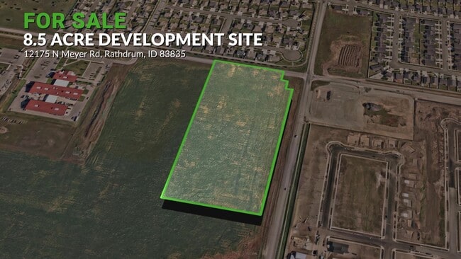
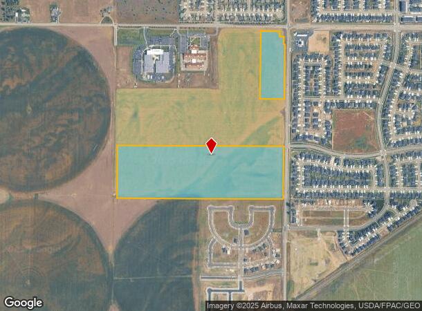

This Property Is For Sale
Property Detail
12175 N Meyer Rd
R00000070100
TAX #22455 EX RW [IN NE] 0751N04W
Residentialacreage
Kootenai
X
Idaho
16055C0217E
55.38 AC
2025
Hayden/Dalton Gardens
2025
Coeur D'Alene
000304
Coeur d'Alene, ID
NEARBY LISTINGS FOR SALE OR LEASE
DEMOGRAPHICS near 12175 N Meyer Rd
1 mile
3 mile
5 mile
2024 Total Population
3,047
13,323
73,557
2029 Population
3,790
16,626
91,735
Pop Growth 2024-2029
+ 24.38%
+ 24.79%
+ 24.71%
Average Age
38
39
40
2024 Total Households
1,077
4,825
27,419
HH Growth 2024-2029
+ 24.79%
+ 25.26%
+ 25.19%
Median Household Inc
$75,900
$74,223
$73,557
Avg Household Size
2.80
2.70
2.60
2024 Avg HH Vehicles
2.00
2.00
2.00
Median Home Value
$470,053
$460,901
$428,558
Median Year Built
2010
2003
2005
Nearby Places
Map Layers
Map Styles
 Street
 Aerial
Transit
 Traffic
 Biking
Places
Listings with unknown addresses are not visible on the map
- Restaurants
- Banks
- Shops
- Fitness
- Groceries
PUBLIC TRANSPORTATION
AIRPORT
Spokane International
Drive
Walk
Distance
Spokane International
50 min
37.9 mi
Nearby Properties
Address
Land Use
TOTAL SIZE
Lot Size
Zoning
Address
Land Use
TOTAL SIZE
Lot Size
Zoning
20,822 SF
10.32 AC
AG
Address
Land Use
TOTAL SIZE
Lot Size
Zoning
125,872 SF
37.45 AC
Address
Land Use
TOTAL SIZE
Lot Size
Zoning
83,208 SF
7.76 AC
Address
Land Use
TOTAL SIZE
Lot Size
Zoning
36,622 SF
60.16 AC
LTIND
Address
Land Use
TOTAL SIZE
Lot Size
Zoning
14,159 SF
17.50 AC
Address
Land Use
TOTAL SIZE
Lot Size
Zoning
54,488 SF
19.50 AC
Address
Land Use
TOTAL SIZE
Lot Size
Zoning
124,611 SF
30.51 AC
AGSUB
Address
Land Use
TOTAL SIZE
Lot Size
Zoning
134,124 SF
43.63 AC
AG
Address
Land Use
TOTAL SIZE
Lot Size
Zoning
23,784 SF
7 AC
Address
Land Use
TOTAL SIZE
Lot Size
Zoning
48,264 SF
10.87 AC
Address
Land Use
TOTAL SIZE
Lot Size
Zoning
4,000 SF
14.02 AC
Address
Land Use
TOTAL SIZE
Lot Size
Zoning
36,000 SF
8.79 AC
Address
Land Use
TOTAL SIZE
Lot Size
Zoning
52,535 SF
5.16 AC
Address
Land Use
TOTAL SIZE
Lot Size
Zoning
47,716 SF
17.22 AC
Address
Land Use
TOTAL SIZE
Lot Size
Zoning
116,010 SF
6 AC
Address
Land Use
TOTAL SIZE
Lot Size
Zoning
88,688 SF
20.51 AC
Address
Land Use
TOTAL SIZE
Lot Size
Zoning
34,236 SF
9.48 AC
Address
Land Use
TOTAL SIZE
Lot Size
Zoning
49,446 SF
5.25 AC
Address
Land Use
TOTAL SIZE
Lot Size
Zoning
49,241 SF
2.81 AC
LTIND
Address
Land Use
TOTAL SIZE
Lot Size
Zoning
28,788 SF
9.38 AC
Address
Land Use
TOTAL SIZE
Lot Size
Zoning
19,600 SF
168.52 AC
LTIND
Address
Land Use
TOTAL SIZE
Lot Size
Zoning
47,845 SF
14.85 AC
Address
Land Use
TOTAL SIZE
Lot Size
Zoning
720 SF
291.71 AC
AG
Address
Land Use
TOTAL SIZE
Lot Size
Zoning
36,064 SF
9.52 AC
Address
Land Use
TOTAL SIZE
Lot Size
Zoning
64,310 SF
4.62 AC
Address
Land Use
TOTAL SIZE
Lot Size
Zoning
52,690 SF
7.13 AC
Address
Land Use
TOTAL SIZE
Lot Size
Zoning
23,675 SF
9.72 AC
Address
Land Use
TOTAL SIZE
Lot Size
Zoning
30,822 SF
10.06 AC
AG
Address
Land Use
TOTAL SIZE
Lot Size
Zoning
24,698 SF
5.02 AC
AGSUB
The World's #1 Commercial Real Estate Marketplace
Connect with us
© 2026 CoStar Group
The information above has been obtained from sources believed reliable. While we do not doubt its accuracy we have not verified it and make no guarantee, warranty or representation about it. It is your responsibility to independently confirm its accuracy and completeness. Any projections, opinions, assumptions, or estimates used are for example only and do not represent the current or future performance of the property. The value of this transaction to you depends on tax and other factors which should be evaluated by your tax, financial, and legal advisors. You and your advisors should conduct a careful, independent investigation of the property to determine to your satisfaction the suitability of the property for your needs.