Property Record
1218 Circle Ave, Forest Park, IL 60130
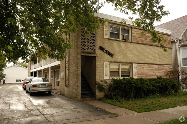

Property Detail
1218 Circle Ave
Chicago-Naperville-Elgin, IL-IN
(12TH) ST (SYNDICATE) SUB OF NE SEC 24-39-12
15-24-202-008-0000
Cook
Apartment
Illinois
B and X Area of moderate flood hazard, usually the area between the limits of the 100-year and 500-year floods.
129,1
2023
0.72 AC
2025
West Cook
816100
Chicago
4,520 SF
NEARBY LISTINGS FOR SALE OR LEASE
DEMOGRAPHICS near 1218 Circle Ave
1 mile
3 mile
5 mile
2025 Total Population
25,567
246,681
625,300
2030 Population
25,440
244,116
612,312
Pop Growth 2025-2030
(0.50%)
(1.04%)
(2.08%)
Average Age
40
40
39
2025 Total Households
9,995
91,704
220,817
HH Growth 2025-2030
(0.45%)
(0.95%)
(2.06%)
Median Household Inc
$80,988
$77,066
$71,336
Avg Household Size
2.50
2.60
2.70
2025 Avg HH Vehicles
1.00
1.00
2.00
Median Home Value
$353,975
$315,300
$293,485
Median Year Built
1947
1947
1948
Nearby Places
Map Layers
Map Styles
 Street
 Aerial
Layers
 Traffic
 Biking
Places
Listings with unknown addresses are not visible on the map
- Restaurants
- Banks
- Shops
- Fitness
- Groceries
PUBLIC TRANSPORTATION
TRANSIT/SUBWAY
Harlem Station (Blue Line - Forest Park Branch) (Blue Line - Chicago Transit Authority "L" Trains (The "L"))
Drive
Walk
Distance
Harlem Station (Blue Line - Forest Park Branch) (Blue Line - Chicago Transit Authority "L" Trains (The "L"))
2 min
14 min
0.7 mi
COMMUTER RAIL
Oak Park Station (Union Pacific West Line - Northeast Illinois Regional Commuter Railroad (Metra))
Drive
Walk
Distance
Oak Park Station (Union Pacific West Line - Northeast Illinois Regional Commuter Railroad (Metra))
5 min
1.9 mi
River Forest Station (Union Pacific West Line - Northeast Illinois Regional Commuter Railroad (Metra))
Drive
Walk
Distance
River Forest Station (Union Pacific West Line - Northeast Illinois Regional Commuter Railroad (Metra))
7 min
2.4 mi
AIRPORT
Chicago Midway International
Drive
Walk
Distance
Chicago Midway International
19 min
9.1 mi
Chicago O'Hare International
Drive
Walk
Distance
Chicago O'Hare International
43 min
15.1 mi
SALE & LEASE HISTORY
LISTING DATE
SALE/LEASE

Dec 22, 2019
For Sale
Nearby Properties
Address
Land Use
TOTAL SIZE
Lot Size
Zoning
Address
Land Use
TOTAL SIZE
Lot Size
Zoning
106,830 SF
1.59 AC
Address
Land Use
TOTAL SIZE
Lot Size
Zoning
86,928 SF
4.80 AC
PD 933
Address
Land Use
TOTAL SIZE
Lot Size
Zoning
1,313,541 SF
44.90 AC
M2-2
Address
Land Use
TOTAL SIZE
Lot Size
Zoning
646,763 SF
17.54 AC
Address
Land Use
TOTAL SIZE
Lot Size
Zoning
377,265 SF
25.73 AC
Address
Land Use
TOTAL SIZE
Lot Size
Zoning
1.59 AC
Address
Land Use
TOTAL SIZE
Lot Size
Zoning
233,538 SF
0.68 AC
Address
Land Use
TOTAL SIZE
Lot Size
Zoning
389,155 SF
17.69 AC
Address
Land Use
TOTAL SIZE
Lot Size
Zoning
459,659 SF
Address
Land Use
TOTAL SIZE
Lot Size
Zoning
189,908 SF
23.82 AC
Address
Land Use
TOTAL SIZE
Lot Size
Zoning
291,681 SF
Address
Land Use
TOTAL SIZE
Lot Size
Zoning
3.26 AC
Address
Land Use
TOTAL SIZE
Lot Size
Zoning
Address
Land Use
TOTAL SIZE
Lot Size
Zoning
578,024 SF
31.94 AC
Address
Land Use
TOTAL SIZE
Lot Size
Zoning
0.66 AC
PD 852
Address
Land Use
TOTAL SIZE
Lot Size
Zoning
108,276 SF
3.80 AC
Address
Land Use
TOTAL SIZE
Lot Size
Zoning
220,137 SF
13.24 AC
Address
Land Use
TOTAL SIZE
Lot Size
Zoning
93,409 SF
2.05 AC
PD 146
Address
Land Use
TOTAL SIZE
Lot Size
Zoning
141,800 SF
3.77 AC
Address
Land Use
TOTAL SIZE
Lot Size
Zoning
225,000 SF
5.82 AC
Address
Land Use
TOTAL SIZE
Lot Size
Zoning
1.65 AC
Address
Land Use
TOTAL SIZE
Lot Size
Zoning
153,954 SF
14.36 AC
Address
Land Use
TOTAL SIZE
Lot Size
Zoning
9,000 SF
0.34 AC
Address
Land Use
TOTAL SIZE
Lot Size
Zoning
101,146 SF
2.24 AC
Address
Land Use
TOTAL SIZE
Lot Size
Zoning
89,919 SF
2.87 AC
Address
Land Use
TOTAL SIZE
Lot Size
Zoning
7.68 AC
Address
Land Use
TOTAL SIZE
Lot Size
Zoning
206,736 SF
10.38 AC
Address
Land Use
TOTAL SIZE
Lot Size
Zoning
193,511 SF
17.89 AC
Address
Land Use
TOTAL SIZE
Lot Size
Zoning
53,800 SF
0.88 AC
Address
Land Use
TOTAL SIZE
Lot Size
Zoning
62,844 SF
3.24 AC
The World's #1 Commercial Real Estate Marketplace
Connect with us
© 2026 CoStar Group
The information above has been obtained from sources believed reliable. While we do not doubt its accuracy we have not verified it and make no guarantee, warranty or representation about it. It is your responsibility to independently confirm its accuracy and completeness. Any projections, opinions, assumptions, or estimates used are for example only and do not represent the current or future performance of the property. The value of this transaction to you depends on tax and other factors which should be evaluated by your tax, financial, and legal advisors. You and your advisors should conduct a careful, independent investigation of the property to determine to your satisfaction the suitability of the property for your needs.