Property Record
12181 Prichard Farm Rd, Maryland Heights, MO 63043


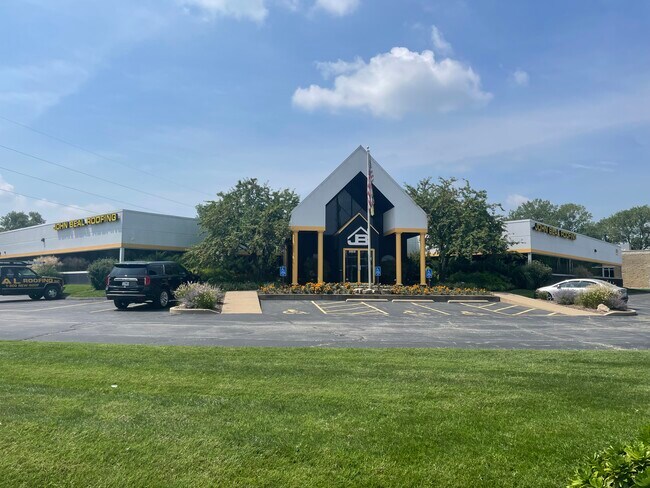
This Property Is For Sale
NEARBY LISTINGS FOR SALE OR LEASE
Property Detail
12181 Prichard Farm Rd
St. Louis, MO-IL
Deerwood Commerce Center Lot 1 Resub
12P-34-0153
DEERWOOD COMMERCE CENTER LOT 1 RESUB LOT 1-B
Officebuilding
St. Louis
AE
Missouri
29189C0177K
1-b
2024
1.55 AC
2025
Earth City/Riverport
215143
St. Louis
20,144 SF
DEMOGRAPHICS near 12181 Prichard Farm Rd
1 Mile
3 Mile
5 Mile
2024 Total Population
3,988
42,642
148,835
2029 Population
3,890
42,500
150,234
Pop Growth 2024-2029
(2.46%)
(0.33%)
+ 0.94%
Average Age
42
40
41
2024 Total Households
1,727
18,801
64,831
HH Growth 2024-2029
(2.49%)
(0.25%)
+ 0.90%
Median Household Inc
$82,102
$82,114
$72,878
Avg Household Size
2.30
2.20
2.20
2024 Avg HH Vehicles
2.00
2.00
2.00
Median Home Value
$182,287
$214,013
$232,511
Median Year Built
1970
1974
1973
Nearby Places
Map Layers
Map Styles
 Street
 Aerial
- Restaurants
- Banks
- Shops
- Fitness
- Groceries
PUBLIC TRANSPORTATION
COMMUTER RAIL
Lambert Airport East Terminal (Lambert Airport Shiloh-Scott - St. Louis MetroLink (MetroLink))
DRIVE
WALK
Distance
Lambert Airport East Terminal (Lambert Airport Shiloh-Scott - St. Louis MetroLink (MetroLink))
14 min
7.9 mi
Lambert Airport Main Terminal (Lambert Airport Shiloh-Scott - St. Louis MetroLink (MetroLink))
DRIVE
WALK
Distance
Lambert Airport Main Terminal (Lambert Airport Shiloh-Scott - St. Louis MetroLink (MetroLink))
16 min
8.4 mi
AIRPORT
St Louis Lambert International
DRIVE
WALK
Distance
St Louis Lambert International
16 min
9.5 mi
Nearby Properties
Address
Land Use
TOTAL SIZE
Lot Size
Zoning
Address
Land Use
TOTAL SIZE
Lot Size
Zoning
2,918,475 SF
30.32 AC
AC1
Address
Land Use
TOTAL SIZE
Lot Size
Zoning
553,382 SF
109.67 AC
FPNU
Address
Land Use
TOTAL SIZE
Lot Size
Zoning
449,698 SF
47.19 AC
R3
Address
Land Use
TOTAL SIZE
Lot Size
Zoning
440,000 SF
2.11 AC
Address
Land Use
TOTAL SIZE
Lot Size
Zoning
256,719 SF
27 AC
104PDM
Address
Land Use
TOTAL SIZE
Lot Size
Zoning
369,418 SF
7.22 AC
104PDM
Address
Land Use
TOTAL SIZE
Lot Size
Zoning
26.89 AC
C-8
Address
Land Use
TOTAL SIZE
Lot Size
Zoning
1,190 SF
49.03 AC
104R-5
Address
Land Use
TOTAL SIZE
Lot Size
Zoning
52,664 SF
13.59 AC
Address
Land Use
TOTAL SIZE
Lot Size
Zoning
542,500 SF
39.91 AC
FPNU
Address
Land Use
TOTAL SIZE
Lot Size
Zoning
332,323 SF
22.40 AC
104PDM
Address
Land Use
TOTAL SIZE
Lot Size
Zoning
488,536 SF
23.53 AC
AF0
Address
Land Use
TOTAL SIZE
Lot Size
Zoning
281,074 SF
8.79 AC
Address
Land Use
TOTAL SIZE
Lot Size
Zoning
312,516 SF
2.18 AC
Address
Land Use
TOTAL SIZE
Lot Size
Zoning
319,398 SF
15.58 AC
10M-3
Address
Land Use
TOTAL SIZE
Lot Size
Zoning
448,590 SF
24.75 AC
M3
Address
Land Use
TOTAL SIZE
Lot Size
Zoning
120,050 SF
1.51 AC
Address
Land Use
TOTAL SIZE
Lot Size
Zoning
389,367 SF
29.15 AC
R6
Address
Land Use
TOTAL SIZE
Lot Size
Zoning
158,499 SF
27.01 AC
FPM3
Address
Land Use
TOTAL SIZE
Lot Size
Zoning
247,086 SF
11.32 AC
104PDM
Address
Land Use
TOTAL SIZE
Lot Size
Zoning
353,407 SF
21.84 AC
104R-4
Address
Land Use
TOTAL SIZE
Lot Size
Zoning
67,891 SF
4 AC
R3
Address
Land Use
TOTAL SIZE
Lot Size
Zoning
205,107 SF
13.43 AC
104PDM
Address
Land Use
TOTAL SIZE
Lot Size
Zoning
232,353 SF
21.13 AC
104PDM
Address
Land Use
TOTAL SIZE
Lot Size
Zoning
216,290 SF
10.39 AC
104MXD
Address
Land Use
TOTAL SIZE
Lot Size
Zoning
225,558 SF
14.48 AC
104R-6
Address
Land Use
TOTAL SIZE
Lot Size
Zoning
316,064 SF
1.84 AC
Address
Land Use
TOTAL SIZE
Lot Size
Zoning
124,000 SF
5.15 AC
102COMCL
Address
Land Use
TOTAL SIZE
Lot Size
Zoning
191,392 SF
4.85 AC
104PDM
Address
Land Use
TOTAL SIZE
Lot Size
Zoning
185,772 SF
9.01 AC
104M-1
The World's #1 Commercial Real Estate Marketplace
Connect with us
© 2026 CoStar Group
The information above has been obtained from sources believed reliable. While we do not doubt its accuracy we have not verified it and make no guarantee, warranty or representation about it. It is your responsibility to independently confirm its accuracy and completeness. Any projections, opinions, assumptions, or estimates used are for example only and do not represent the current or future performance of the property. The value of this transaction to you depends on tax and other factors which should be evaluated by your tax, financial, and legal advisors. You and your advisors should conduct a careful, independent investigation of the property to determine to your satisfaction the suitability of the property for your needs.