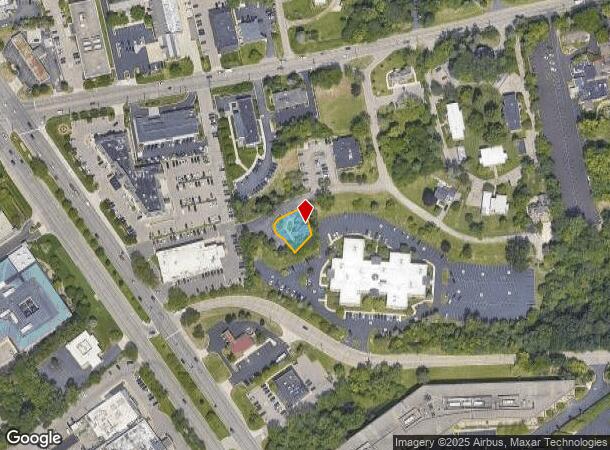
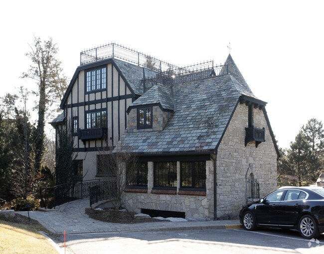
Property Record
122 Concord Rd, Bloomfield Hills, MI 48304

NEARBY LISTINGS FOR SALE OR LEASE
Property Detail
122 Concord Rd
Detroit-Warren-Dearborn, MI
Bloomfield Downs
19-14-178-008
T2N, R10E, SEC 14 BLOOMFIELD DOWNS LOT 11
Officebuilding
Oakland
AE
Michigan
26125C0528F
11
2024
0.18 AC
2024
Bloomfield
152000
Detroit
3,845 SF
DEMOGRAPHICS near 122 Concord Rd
1 Mile
3 Mile
5 Mile
2024 Total Population
3,032
55,316
171,892
2029 Population
3,063
54,953
171,118
Pop Growth 2024-2029
+ 1.02%
(0.66%)
(0.45%)
Average Age
49
44
42
2024 Total Households
1,148
20,950
69,282
HH Growth 2024-2029
+ 1.31%
(0.67%)
(0.44%)
Median Household Inc
$194,175
$152,569
$110,413
Avg Household Size
2.40
2.60
2.40
2024 Avg HH Vehicles
2.00
2.00
2.00
Median Home Value
$722,105
$566,491
$440,921
Median Year Built
1979
1968
1969
Nearby Places
Map Layers
Map Styles
 Street
 Aerial
- Restaurants
- Banks
- Shops
- Fitness
- Groceries
PUBLIC TRANSPORTATION
COMMUTER RAIL
Pontiac Amtrak Station (Wolverine - Amtrak)
DRIVE
WALK
Distance
Pontiac Amtrak Station (Wolverine - Amtrak)
10 min
4.9 mi
Troy Amtrak Station (Wolverine - Amtrak)
DRIVE
WALK
Distance
Troy Amtrak Station (Wolverine - Amtrak)
12 min
5.4 mi
AIRPORT
Windsor International
DRIVE
WALK
Distance
Windsor International
57 min
34.5 mi
Detroit Metro Wayne County
DRIVE
WALK
Distance
Detroit Metro Wayne County
55 min
41.6 mi
Freight Ports
Port of Toledo
DRIVE
WALK
Distance
Port of Toledo
105 min
76.2 mi
Nearby Properties
Address
Land Use
TOTAL SIZE
Lot Size
Zoning
Address
Land Use
TOTAL SIZE
Lot Size
Zoning
711,360 SF
43.86 AC
Address
Land Use
TOTAL SIZE
Lot Size
Zoning
111,030 SF
0.97 AC
BI
Address
Land Use
TOTAL SIZE
Lot Size
Zoning
149,395 SF
1.02 AC
BI
Address
Land Use
TOTAL SIZE
Lot Size
Zoning
608,251 SF
50.49 AC
II
Address
Land Use
TOTAL SIZE
Lot Size
Zoning
143,160 SF
0.84 AC
BI
Address
Land Use
TOTAL SIZE
Lot Size
Zoning
601,151 SF
Address
Land Use
TOTAL SIZE
Lot Size
Zoning
289,110 SF
6.07 AC
BI
Address
Land Use
TOTAL SIZE
Lot Size
Zoning
360,186 SF
38.44 AC
RM2
Address
Land Use
TOTAL SIZE
Lot Size
Zoning
154,370 SF
8.80 AC
BI
Address
Land Use
TOTAL SIZE
Lot Size
Zoning
242,512 SF
6.60 AC
BI
Address
Land Use
TOTAL SIZE
Lot Size
Zoning
203,643 SF
9.85 AC
IV
Address
Land Use
TOTAL SIZE
Lot Size
Zoning
97,172 SF
13.82 AC
BI
Address
Land Use
TOTAL SIZE
Lot Size
Zoning
267,393 SF
11.11 AC
BI
Address
Land Use
TOTAL SIZE
Lot Size
Zoning
225,890 SF
10.10 AC
OM
Address
Land Use
TOTAL SIZE
Lot Size
Zoning
109,570 SF
0.68 AC
BI
Address
Land Use
TOTAL SIZE
Lot Size
Zoning
275,889 SF
12.34 AC
BI
Address
Land Use
TOTAL SIZE
Lot Size
Zoning
454,573 SF
Address
Land Use
TOTAL SIZE
Lot Size
Zoning
80,334 SF
0.57 AC
BI
Address
Land Use
TOTAL SIZE
Lot Size
Zoning
219,274 SF
9.75 AC
BI
Address
Land Use
TOTAL SIZE
Lot Size
Zoning
160,535 SF
9.52 AC
OM
Address
Land Use
TOTAL SIZE
Lot Size
Zoning
903,018 SF
73.92 AC
II
Address
Land Use
TOTAL SIZE
Lot Size
Zoning
158,374 SF
12.35 AC
BI
Address
Land Use
TOTAL SIZE
Lot Size
Zoning
93,734 SF
10.63 AC
MM
Address
Land Use
TOTAL SIZE
Lot Size
Zoning
56,867 SF
3.80 AC
BI
Address
Land Use
TOTAL SIZE
Lot Size
Zoning
52,787 SF
0.34 AC
BI
Address
Land Use
TOTAL SIZE
Lot Size
Zoning
149,135 SF
7.59 AC
OM
Address
Land Use
TOTAL SIZE
Lot Size
Zoning
53,379 SF
139.07 AC
Address
Land Use
TOTAL SIZE
Lot Size
Zoning
75,743 SF
0.67 AC
BI
Address
Land Use
TOTAL SIZE
Lot Size
Zoning
72,029 SF
0.57 AC
BV
Address
Land Use
TOTAL SIZE
Lot Size
Zoning
64,224 SF
2.43 AC
BI
The World's #1 Commercial Real Estate Marketplace
Connect with us
© 2025 CoStar Group
The information above has been obtained from sources believed reliable. While we do not doubt its accuracy we have not verified it and make no guarantee, warranty or representation about it. It is your responsibility to independently confirm its accuracy and completeness. Any projections, opinions, assumptions, or estimates used are for example only and do not represent the current or future performance of the property. The value of this transaction to you depends on tax and other factors which should be evaluated by your tax, financial, and legal advisors. You and your advisors should conduct a careful, independent investigation of the property to determine to your satisfaction the suitability of the property for your needs.