Property Record
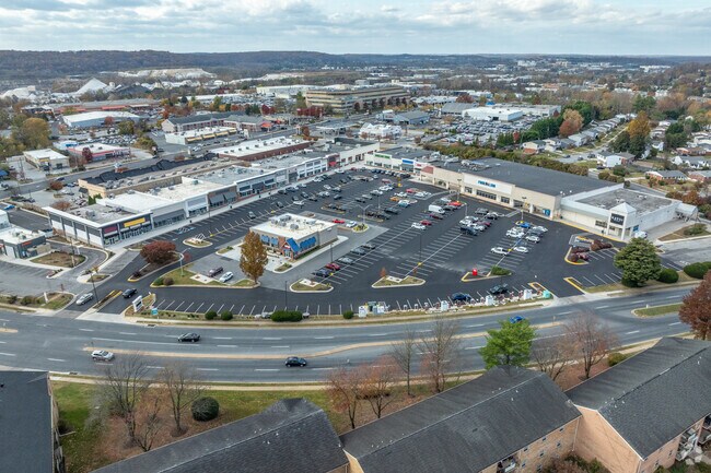
122 Cranbrook Rd, Cockeysville, MD 21030

Property Detail
122 Cranbrook Rd
08-1600010071
11.155 AC NS
Restaurantdrivein
BALTIMORE
BRCCC
Maryland
B and X Area of moderate flood hazard, usually the area between the limits of the 100-year and 500-year floods.
11.15 AC
2024
Route 83 Corridor North
2025
Baltimore
408503
Baltimore-Columbia-Towson, MD
20,446 SF
NEARBY LISTINGS FOR SALE OR LEASE
DEMOGRAPHICS near 122 Cranbrook Rd
1 mile
3 mile
5 mile
2025 Total Population
10,806
54,543
100,792
2030 Population
10,822
54,690
101,355
Pop Growth 2025-2030
+ 0.15%
+ 0.27%
+ 0.56%
Average Age
37
43
43
2025 Total Households
4,491
22,591
41,371
HH Growth 2025-2030
+ 0.07%
+ 0.28%
+ 0.68%
Median Household Inc
$84,465
$105,379
$108,425
Avg Household Size
2.40
2.30
2.30
2025 Avg HH Vehicles
2.00
2.00
2.00
Median Home Value
$391,148
$463,735
$492,800
Median Year Built
1974
1978
1977
Nearby Places
Map Layers
Map Styles
 Street
 Aerial
Layers
 Traffic
 Biking
Places
Listings with unknown addresses are not visible on the map
- Restaurants
- Banks
- Shops
- Fitness
- Groceries
PUBLIC TRANSPORTATION
AIRPORT
Baltimore/Washington International Thurgood Marshall
Drive
Walk
Distance
Baltimore/Washington International Thurgood Marshall
40 min
26.0 mi
Freight Ports
Port of Baltimore
Drive
Walk
Distance
Port of Baltimore
34 min
17.8 mi
SALE & LEASE HISTORY
LISTING DATE
SALE/LEASE

Jun 11, 2019
For Lease
Nearby Properties
Address
Land Use
TOTAL SIZE
Lot Size
Zoning
Address
Land Use
TOTAL SIZE
Lot Size
Zoning
217,147 SF
5.08 AC
MLIM
Address
Land Use
TOTAL SIZE
Lot Size
Zoning
513,056 SF
55.49 AC
BM
Address
Land Use
TOTAL SIZE
Lot Size
Zoning
343,606 SF
19.65 AC
Address
Land Use
TOTAL SIZE
Lot Size
Zoning
720,989 SF
32.65 AC
Address
Land Use
TOTAL SIZE
Lot Size
Zoning
595,100 SF
5.73 AC
Address
Land Use
TOTAL SIZE
Lot Size
Zoning
38.89 AC
DR16
Address
Land Use
TOTAL SIZE
Lot Size
Zoning
512,317 SF
2.76 AC
BM
Address
Land Use
TOTAL SIZE
Lot Size
Zoning
13,468 SF
32.08 AC
DR16
Address
Land Use
TOTAL SIZE
Lot Size
Zoning
28.74 AC
DR16
Address
Land Use
TOTAL SIZE
Lot Size
Zoning
362,686 SF
88.84 AC
MR
Address
Land Use
TOTAL SIZE
Lot Size
Zoning
489,483 SF
84.32 AC
RC4
Address
Land Use
TOTAL SIZE
Lot Size
Zoning
237,800 SF
1.28 AC
BM
Address
Land Use
TOTAL SIZE
Lot Size
Zoning
330,145 SF
16.20 AC
Address
Land Use
TOTAL SIZE
Lot Size
Zoning
26.73 AC
DR16
Address
Land Use
TOTAL SIZE
Lot Size
Zoning
250,462 SF
185.60 AC
Address
Land Use
TOTAL SIZE
Lot Size
Zoning
330,802 SF
14.81 AC
ML-IM
Address
Land Use
TOTAL SIZE
Lot Size
Zoning
176,584 SF
31 AC
Address
Land Use
TOTAL SIZE
Lot Size
Zoning
125,398 SF
15.13 AC
BM
Address
Land Use
TOTAL SIZE
Lot Size
Zoning
44.76 AC
DR3.5
Address
Land Use
TOTAL SIZE
Lot Size
Zoning
Address
Land Use
TOTAL SIZE
Lot Size
Zoning
138,000 SF
3.09 AC
Address
Land Use
TOTAL SIZE
Lot Size
Zoning
172,782 SF
5.35 AC
ML-IM
Address
Land Use
TOTAL SIZE
Lot Size
Zoning
14.49 AC
DR16
Address
Land Use
TOTAL SIZE
Lot Size
Zoning
94,534 SF
15.68 AC
BLCCC
Address
Land Use
TOTAL SIZE
Lot Size
Zoning
18.07 AC
DR3.5
Address
Land Use
TOTAL SIZE
Lot Size
Zoning
13.46 AC
DR16
Address
Land Use
TOTAL SIZE
Lot Size
Zoning
326,069 SF
9.28 AC
ML-IM
Address
Land Use
TOTAL SIZE
Lot Size
Zoning
18.68 AC
DR3.5
Address
Land Use
TOTAL SIZE
Lot Size
Zoning
204,329 SF
25.45 AC
ML
Address
Land Use
TOTAL SIZE
Lot Size
Zoning
143,260 SF
7.31 AC
ML
The World's #1 Commercial Real Estate Marketplace
Connect with us
© 2026 CoStar Group
The information above has been obtained from sources believed reliable. While we do not doubt its accuracy we have not verified it and make no guarantee, warranty or representation about it. It is your responsibility to independently confirm its accuracy and completeness. Any projections, opinions, assumptions, or estimates used are for example only and do not represent the current or future performance of the property. The value of this transaction to you depends on tax and other factors which should be evaluated by your tax, financial, and legal advisors. You and your advisors should conduct a careful, independent investigation of the property to determine to your satisfaction the suitability of the property for your needs.