Property Record
122 Crossover Rd, Beulaville, NC 28518


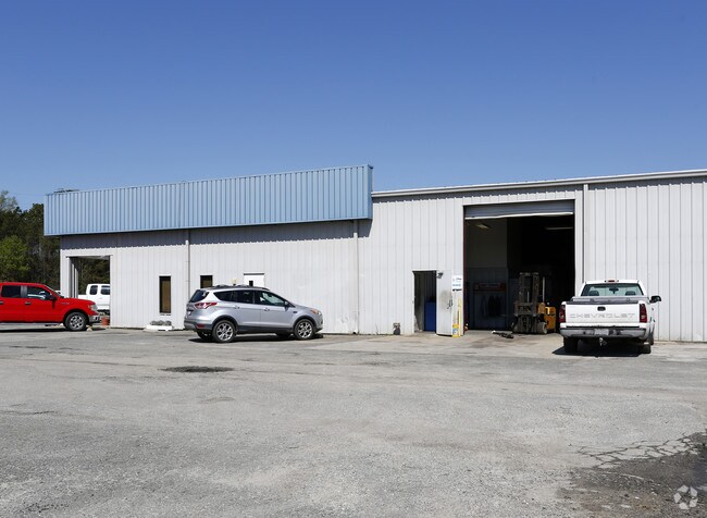
Property Detail
122 Crossover Rd
07-1233
INDUSTRIAL HYDRAULICS
Commercialnec
DUPLIN
B and X Area of moderate flood hazard, usually the area between the limits of the 100-year and 500-year floods.
North Carolina
2025
7
2025
1.78 AC
0905012042
North Carolina Southeast Area
18,060 SF
Other Market Areas
NEARBY LISTINGS FOR SALE OR LEASE
-
-
View all Beulaville listings for sale on LoopNet.com
DEMOGRAPHICS near 122 Crossover Rd
1 mile
3 mile
5 mile
2025 Total Population
1,036
3,554
7,185
2030 Population
1,051
3,697
7,510
Pop Growth 2025-2030
+ 1.45%
+ 4.02%
+ 4.52%
Average Age
44
42
42
2025 Total Households
475
1,509
2,938
HH Growth 2025-2030
+ 1.47%
+ 4.04%
+ 4.59%
Median Household Inc
$44,213
$54,386
$58,424
Avg Household Size
2.20
2.30
2.40
2025 Avg HH Vehicles
2.00
2.00
2.00
Median Home Value
$186,597
$170,166
$147,822
Median Year Built
1991
1989
1986
Nearby Places
Map Layers
Map Styles
 Street
 Aerial
Layers
 Traffic
 Biking
Places
Listings with unknown addresses are not visible on the map
- Restaurants
- Banks
- Shops
- Fitness
- Groceries
PUBLIC TRANSPORTATION
AIRPORT
Albert J Ellis
Drive
Walk
Distance
Albert J Ellis
28 min
16.1 mi
SALE & LEASE HISTORY
LISTING DATE
SALE/LEASE

Jun 24, 2022
For Sale
Nearby Properties
Address
Land Use
TOTAL SIZE
Lot Size
Zoning
Address
Land Use
TOTAL SIZE
Lot Size
Zoning
0.96 AC
Address
Land Use
TOTAL SIZE
Lot Size
Zoning
104,128 SF
26.52 AC
Address
Land Use
TOTAL SIZE
Lot Size
Zoning
1 SF
42.84 AC
Address
Land Use
TOTAL SIZE
Lot Size
Zoning
14,447 SF
1.31 AC
Address
Land Use
TOTAL SIZE
Lot Size
Zoning
Address
Land Use
TOTAL SIZE
Lot Size
Zoning
21.40 AC
Address
Land Use
TOTAL SIZE
Lot Size
Zoning
81,208 SF
6.46 AC
Address
Land Use
TOTAL SIZE
Lot Size
Zoning
15.23 AC
Address
Land Use
TOTAL SIZE
Lot Size
Zoning
Address
Land Use
TOTAL SIZE
Lot Size
Zoning
Address
Land Use
TOTAL SIZE
Lot Size
Zoning
2,924 SF
1.17 AC
Address
Land Use
TOTAL SIZE
Lot Size
Zoning
3,621 SF
2.11 AC
Address
Land Use
TOTAL SIZE
Lot Size
Zoning
784 SF
6 AC
Address
Land Use
TOTAL SIZE
Lot Size
Zoning
4,692 SF
4.21 AC
Address
Land Use
TOTAL SIZE
Lot Size
Zoning
4,100 SF
3.44 AC
Address
Land Use
TOTAL SIZE
Lot Size
Zoning
Address
Land Use
TOTAL SIZE
Lot Size
Zoning
30.40 AC
Address
Land Use
TOTAL SIZE
Lot Size
Zoning
3,437 SF
0.65 AC
Address
Land Use
TOTAL SIZE
Lot Size
Zoning
31,860 SF
4.46 AC
Address
Land Use
TOTAL SIZE
Lot Size
Zoning
71.32 AC
Address
Land Use
TOTAL SIZE
Lot Size
Zoning
10.70 AC
Address
Land Use
TOTAL SIZE
Lot Size
Zoning
10,465 SF
7.21 AC
Address
Land Use
TOTAL SIZE
Lot Size
Zoning
Address
Land Use
TOTAL SIZE
Lot Size
Zoning
19,920 SF
3.66 AC
Address
Land Use
TOTAL SIZE
Lot Size
Zoning
8,120 SF
0.86 AC
Address
Land Use
TOTAL SIZE
Lot Size
Zoning
243,377 SF
34.32 AC
Address
Land Use
TOTAL SIZE
Lot Size
Zoning
Address
Land Use
TOTAL SIZE
Lot Size
Zoning
9,000 SF
35.30 AC
Address
Land Use
TOTAL SIZE
Lot Size
Zoning
10,250 SF
1.04 AC
Address
Land Use
TOTAL SIZE
Lot Size
Zoning
The World's #1 Commercial Real Estate Marketplace
Connect with us
© 2026 CoStar Group
The information above has been obtained from sources believed reliable. While we do not doubt its accuracy we have not verified it and make no guarantee, warranty or representation about it. It is your responsibility to independently confirm its accuracy and completeness. Any projections, opinions, assumptions, or estimates used are for example only and do not represent the current or future performance of the property. The value of this transaction to you depends on tax and other factors which should be evaluated by your tax, financial, and legal advisors. You and your advisors should conduct a careful, independent investigation of the property to determine to your satisfaction the suitability of the property for your needs.