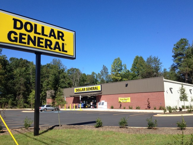
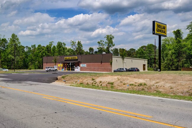
Property Record
122 Highway 172, Hubert, NC 28539


Property Detail
122 Highway 172
164527
L2 KCI HUBERT
Storebuilding
ONSLOW
HB
North Carolina
B and X Area of moderate flood hazard, usually the area between the limits of the 100-year and 500-year floods.
2
2025
2.37 AC
2025
Coastal Carolina
002803
Other Market Areas
9,100 SF
Jacksonville, NC
NEARBY LISTINGS FOR SALE OR LEASE
-
-
View all Hubert listings for sale on LoopNet.com
DEMOGRAPHICS near 122 Highway 172
1 mile
3 mile
5 mile
2025 Total Population
2,313
13,098
26,248
2030 Population
2,446
13,790
27,828
Pop Growth 2025-2030
+ 5.75%
+ 5.28%
+ 6.02%
Average Age
35
33
34
2025 Total Households
863
4,136
9,145
HH Growth 2025-2030
+ 6.03%
+ 6.33%
+ 6.65%
Median Household Inc
$67,874
$69,459
$68,990
Avg Household Size
2.60
2.60
2.60
2025 Avg HH Vehicles
2.00
2.00
2.00
Median Home Value
$248,165
$251,252
$265,077
Median Year Built
1998
1999
1999
Nearby Places
Map Layers
Map Styles
 Street
 Aerial
Transit
 Traffic
 Biking
Places
Listings with unknown addresses are not visible on the map
- Restaurants
- Banks
- Shops
- Fitness
- Groceries
PUBLIC TRANSPORTATION
AIRPORT
Albert J Ellis
Drive
Walk
Distance
Albert J Ellis
43 min
26.3 mi
Coastal Carolina Regional
Drive
Walk
Distance
Coastal Carolina Regional
61 min
42.2 mi
Freight Ports
Port of Morehead City
Drive
Walk
Distance
Port of Morehead City
52 min
32.2 mi
SALE & LEASE HISTORY
LISTING DATE
SALE/LEASE

May 13, 2019
For Sale
Nearby Properties
Address
Land Use
TOTAL SIZE
Lot Size
Zoning
Address
Land Use
TOTAL SIZE
Lot Size
Zoning
10,350 SF
22.80 AC
HB
Address
Land Use
TOTAL SIZE
Lot Size
Zoning
1,320 SF
59.95 AC
CB
Address
Land Use
TOTAL SIZE
Lot Size
Zoning
45,900 SF
7.96 AC
RA(CZ)
Address
Land Use
TOTAL SIZE
Lot Size
Zoning
218.40 AC
R-15
Address
Land Use
TOTAL SIZE
Lot Size
Zoning
1,325 SF
17.24 AC
HB
Address
Land Use
TOTAL SIZE
Lot Size
Zoning
405.95 AC
RA
Address
Land Use
TOTAL SIZE
Lot Size
Zoning
2,000 SF
6.29 AC
HB
Address
Land Use
TOTAL SIZE
Lot Size
Zoning
55.80 AC
R-8M
Address
Land Use
TOTAL SIZE
Lot Size
Zoning
9,020 SF
1.18 AC
CB
Address
Land Use
TOTAL SIZE
Lot Size
Zoning
4,141 SF
2.33 AC
R-15
Address
Land Use
TOTAL SIZE
Lot Size
Zoning
6,237 SF
2.06 AC
HB
Address
Land Use
TOTAL SIZE
Lot Size
Zoning
21.51 AC
HB
Address
Land Use
TOTAL SIZE
Lot Size
Zoning
767.26 AC
RA
Address
Land Use
TOTAL SIZE
Lot Size
Zoning
8,990 SF
2.32 AC
HB
Address
Land Use
TOTAL SIZE
Lot Size
Zoning
7,548 SF
1.66 AC
R-8M
Address
Land Use
TOTAL SIZE
Lot Size
Zoning
11,131 SF
2 AC
R-8M
Address
Land Use
TOTAL SIZE
Lot Size
Zoning
59.77 AC
HB
Address
Land Use
TOTAL SIZE
Lot Size
Zoning
95.89 AC
R-8M
Address
Land Use
TOTAL SIZE
Lot Size
Zoning
4,000 SF
1.65 AC
CB
Address
Land Use
TOTAL SIZE
Lot Size
Zoning
40.72 AC
RA
Address
Land Use
TOTAL SIZE
Lot Size
Zoning
3,157 SF
2.73 AC
R-15
Address
Land Use
TOTAL SIZE
Lot Size
Zoning
36.83 AC
RA
Address
Land Use
TOTAL SIZE
Lot Size
Zoning
6,937 SF
2.55 AC
CB
Address
Land Use
TOTAL SIZE
Lot Size
Zoning
62.18 AC
HB
Address
Land Use
TOTAL SIZE
Lot Size
Zoning
2,400 SF
1.26 AC
HB
Address
Land Use
TOTAL SIZE
Lot Size
Zoning
3,311 SF
2.37 AC
R-15
Address
Land Use
TOTAL SIZE
Lot Size
Zoning
70.29 AC
R-15
Address
Land Use
TOTAL SIZE
Lot Size
Zoning
1,704 SF
4.97 AC
R-5
Address
Land Use
TOTAL SIZE
Lot Size
Zoning
285.44 AC
RA
The World's #1 Commercial Real Estate Marketplace
Connect with us
© 2026 CoStar Group
The information above has been obtained from sources believed reliable. While we do not doubt its accuracy we have not verified it and make no guarantee, warranty or representation about it. It is your responsibility to independently confirm its accuracy and completeness. Any projections, opinions, assumptions, or estimates used are for example only and do not represent the current or future performance of the property. The value of this transaction to you depends on tax and other factors which should be evaluated by your tax, financial, and legal advisors. You and your advisors should conduct a careful, independent investigation of the property to determine to your satisfaction the suitability of the property for your needs.