No Photo
Property Record
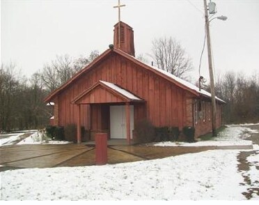
122 N Main St, Georgetown, OH 45121

Property Detail
122 N Main St
Cincinnati, OH-KY-IN
IN LOT 183 PLEASANT TWP GEORGETOWN VILLAGE GEORGETOWN EVSD
33-068480-0000
Brown
Restaurantbuilding
Ohio
B and X Area of moderate flood hazard, usually the area between the limits of the 100-year and 500-year floods.
183
2025
0.08 AC
2025
Brown County
951800
Cincinnati/Dayton
874 SF
NEARBY LISTINGS FOR SALE OR LEASE
-
-
View all Georgetown listings for sale on LoopNet.com
DEMOGRAPHICS near 122 N Main St
1 mile
3 mile
5 mile
2025 Total Population
1,002
2,192
5,395
2030 Population
981
2,150
5,391
Pop Growth 2025-2030
(2.10%)
(1.92%)
(0.07%)
Average Age
39
40
42
2025 Total Households
402
864
2,101
HH Growth 2025-2030
(2.24%)
(1.97%)
0.00%
Median Household Inc
$46,250
$56,363
$69,715
Avg Household Size
2.50
2.50
2.50
2025 Avg HH Vehicles
2.00
2.00
3.00
Median Home Value
$94,055
$137,333
$176,050
Median Year Built
1974
1977
1983
Nearby Places
Map Layers
Map Styles
 Street
 Aerial
Layers
 Traffic
 Biking
Places
Listings with unknown addresses are not visible on the map
- Restaurants
- Banks
- Shops
- Fitness
- Groceries
Nearby Properties
Address
Land Use
TOTAL SIZE
Lot Size
Zoning
Address
Land Use
TOTAL SIZE
Lot Size
Zoning
25.97 AC
Address
Land Use
TOTAL SIZE
Lot Size
Zoning
21.69 AC
Address
Land Use
TOTAL SIZE
Lot Size
Zoning
7,550 SF
85.87 AC
Address
Land Use
TOTAL SIZE
Lot Size
Zoning
12.67 AC
Address
Land Use
TOTAL SIZE
Lot Size
Zoning
34.61 AC
Address
Land Use
TOTAL SIZE
Lot Size
Zoning
5.21 AC
Address
Land Use
TOTAL SIZE
Lot Size
Zoning
5.25 AC
Address
Land Use
TOTAL SIZE
Lot Size
Zoning
Address
Land Use
TOTAL SIZE
Lot Size
Zoning
Address
Land Use
TOTAL SIZE
Lot Size
Zoning
12.37 AC
Address
Land Use
TOTAL SIZE
Lot Size
Zoning
Address
Land Use
TOTAL SIZE
Lot Size
Zoning
2.06 AC
Address
Land Use
TOTAL SIZE
Lot Size
Zoning
23.82 AC
Address
Land Use
TOTAL SIZE
Lot Size
Zoning
340.75 AC
Address
Land Use
TOTAL SIZE
Lot Size
Zoning
7.77 AC
Address
Land Use
TOTAL SIZE
Lot Size
Zoning
1,820 SF
0.71 AC
Address
Land Use
TOTAL SIZE
Lot Size
Zoning
228.60 AC
Address
Land Use
TOTAL SIZE
Lot Size
Zoning
234.69 AC
Address
Land Use
TOTAL SIZE
Lot Size
Zoning
1.02 AC
Address
Land Use
TOTAL SIZE
Lot Size
Zoning
7,354 SF
3.90 AC
Address
Land Use
TOTAL SIZE
Lot Size
Zoning
10.30 AC
Address
Land Use
TOTAL SIZE
Lot Size
Zoning
Address
Land Use
TOTAL SIZE
Lot Size
Zoning
217.37 AC
Address
Land Use
TOTAL SIZE
Lot Size
Zoning
Address
Land Use
TOTAL SIZE
Lot Size
Zoning
22.70 AC
Address
Land Use
TOTAL SIZE
Lot Size
Zoning
Address
Land Use
TOTAL SIZE
Lot Size
Zoning
18.52 AC
Address
Land Use
TOTAL SIZE
Lot Size
Zoning
1.61 AC
Address
Land Use
TOTAL SIZE
Lot Size
Zoning
5,124 SF
8 AC
Address
Land Use
TOTAL SIZE
Lot Size
Zoning
190.08 AC
The World's #1 Commercial Real Estate Marketplace
Connect with us
© 2026 CoStar Group
The information above has been obtained from sources believed reliable. While we do not doubt its accuracy we have not verified it and make no guarantee, warranty or representation about it. It is your responsibility to independently confirm its accuracy and completeness. Any projections, opinions, assumptions, or estimates used are for example only and do not represent the current or future performance of the property. The value of this transaction to you depends on tax and other factors which should be evaluated by your tax, financial, and legal advisors. You and your advisors should conduct a careful, independent investigation of the property to determine to your satisfaction the suitability of the property for your needs.