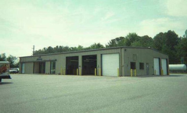
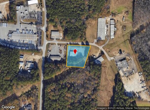
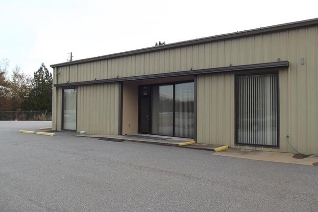
Property Record
122 Newton Bridge Industri Way, Athens, GA 30607

NEARBY LISTINGS FOR SALE OR LEASE
Property Detail
122 Newton Bridge Industri Way
Athens-Clarke County, GA
Com-St-030->00-03
104A2-B-002
SUBD BLK: B,LOT: 4; DEEDED ACS: 1
Industrialgeneral
Clarke
X
Georgia
13059C0015E
4
2025
1.76 AC
2025
North Athens
010602
Other Market Areas
5,940 SF
DEMOGRAPHICS near 122 Newton Bridge Industri Way
1 Mile
3 Mile
5 Mile
2024 Total Population
2,514
27,734
83,891
2029 Population
2,507
27,860
84,838
Pop Growth 2024-2029
(0.28%)
+ 0.45%
+ 1.13%
Average Age
36
35
34
2024 Total Households
819
11,036
31,891
HH Growth 2024-2029
(0.37%)
+ 0.41%
+ 1.08%
Median Household Inc
$45,259
$48,607
$46,839
Avg Household Size
2.80
2.40
2.30
2024 Avg HH Vehicles
2.00
2.00
2.00
Median Home Value
$220,408
$230,747
$250,600
Median Year Built
1986
1984
1983
Nearby Places
Map Layers
Map Styles
 Street
 Aerial
- Restaurants
- Banks
- Shops
- Fitness
- Groceries
SALE & LEASE HISTORY
LISTING DATE
SALE/LEASE

Sep 25, 2016
For Lease
Nearby Properties
Address
Land Use
TOTAL SIZE
Lot Size
Zoning
Address
Land Use
TOTAL SIZE
Lot Size
Zoning
11.36 AC
G
Address
Land Use
TOTAL SIZE
Lot Size
Zoning
85,608 SF
63.75 AC
RM-2
Address
Land Use
TOTAL SIZE
Lot Size
Zoning
213,612 SF
3.07 AC
C-D
Address
Land Use
TOTAL SIZE
Lot Size
Zoning
56.15 AC
G
Address
Land Use
TOTAL SIZE
Lot Size
Zoning
112,071 SF
5.27 AC
E-O
Address
Land Use
TOTAL SIZE
Lot Size
Zoning
8,357 SF
22.38 AC
RM-2
Address
Land Use
TOTAL SIZE
Lot Size
Zoning
118,239 SF
2.80 AC
C-D(ND)
Address
Land Use
TOTAL SIZE
Lot Size
Zoning
8,423 SF
1.07 AC
C-D
Address
Land Use
TOTAL SIZE
Lot Size
Zoning
77,919 SF
8 AC
E-I
Address
Land Use
TOTAL SIZE
Lot Size
Zoning
64,466 SF
1.08 AC
C-D
Address
Land Use
TOTAL SIZE
Lot Size
Zoning
83,755 SF
1.70 AC
C-D
Address
Land Use
TOTAL SIZE
Lot Size
Zoning
3,628 SF
6.57 AC
RM-2
Address
Land Use
TOTAL SIZE
Lot Size
Zoning
9,956 SF
7.20 AC
E-O(PD)
Address
Land Use
TOTAL SIZE
Lot Size
Zoning
49.58 AC
G
Address
Land Use
TOTAL SIZE
Lot Size
Zoning
13,224 SF
3.80 AC
C-D
Address
Land Use
TOTAL SIZE
Lot Size
Zoning
58,706 SF
12.86 AC
C-G
Address
Land Use
TOTAL SIZE
Lot Size
Zoning
60,737 SF
2.66 AC
C-D
Address
Land Use
TOTAL SIZE
Lot Size
Zoning
12.87 AC
P
Address
Land Use
TOTAL SIZE
Lot Size
Zoning
20.74 AC
G
Address
Land Use
TOTAL SIZE
Lot Size
Zoning
72,072 SF
7.59 AC
RM-2
Address
Land Use
TOTAL SIZE
Lot Size
Zoning
19.21 AC
G
Address
Land Use
TOTAL SIZE
Lot Size
Zoning
664,513 SF
84.46 AC
I
Address
Land Use
TOTAL SIZE
Lot Size
Zoning
106,760 SF
10.38 AC
E-O
Address
Land Use
TOTAL SIZE
Lot Size
Zoning
36.93 AC
G
Address
Land Use
TOTAL SIZE
Lot Size
Zoning
11,520 SF
5.03 AC
RM-2
Address
Land Use
TOTAL SIZE
Lot Size
Zoning
8,756 SF
2.83 AC
C-D
Address
Land Use
TOTAL SIZE
Lot Size
Zoning
8.27 AC
G
Address
Land Use
TOTAL SIZE
Lot Size
Zoning
1.25 AC
G
Address
Land Use
TOTAL SIZE
Lot Size
Zoning
38,060 SF
7.84 AC
C-D(ND)
Address
Land Use
TOTAL SIZE
Lot Size
Zoning
39.94 AC
C-O
The World's #1 Commercial Real Estate Marketplace
Connect with us
© 2025 CoStar Group
The information above has been obtained from sources believed reliable. While we do not doubt its accuracy we have not verified it and make no guarantee, warranty or representation about it. It is your responsibility to independently confirm its accuracy and completeness. Any projections, opinions, assumptions, or estimates used are for example only and do not represent the current or future performance of the property. The value of this transaction to you depends on tax and other factors which should be evaluated by your tax, financial, and legal advisors. You and your advisors should conduct a careful, independent investigation of the property to determine to your satisfaction the suitability of the property for your needs.