Property Record
122 Saxon Ave, Bay Shore, NY 11706
NEARBY LISTINGS FOR SALE OR LEASE
-
-
View all Bay Shore listings for sale on LoopNet.com
Property Detail
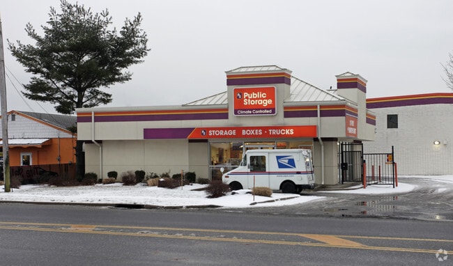
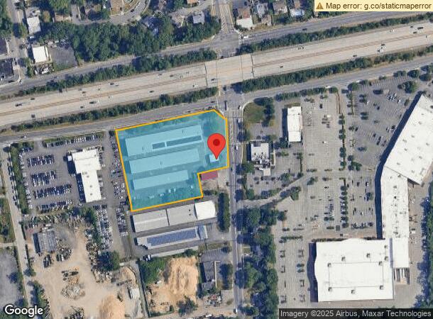
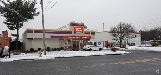
122 Saxon Ave
Nassau County-Suffolk County, NY
N042N00000000
0500-318-00-02-00-041-007
Suffolk
Warehouse
New York
X
200
36103C0876H
3.20 AC
0
Southwestern Suffolk
2024
Long Island (New York)
147301
DEMOGRAPHICS near 122 Saxon Ave
1 Mile
3 Mile
5 Mile
2024 Total Population
14,841
107,126
230,663
2029 Population
14,541
104,119
224,296
Pop Growth 2024-2029
(2.02%)
(2.81%)
(2.76%)
Average Age
40
39
39
2024 Total Households
5,165
31,873
66,745
HH Growth 2024-2029
(1.99%)
(2.76%)
(2.80%)
Median Household Inc
$104,944
$111,412
$112,833
Avg Household Size
2.80
3.10
3.20
2024 Avg HH Vehicles
2.00
2.00
2.00
Median Home Value
$422,469
$438,136
$438,670
Median Year Built
1967
1964
1964
Nearby Places
- Restaurants
- Banks
- Shops
- Fitness
- Groceries
PUBLIC TRANSPORTATION
COMMUTER RAIL
Islip Station (Montauk Branch - Long Island Rail Road)
DRIVE
WALK
Distance
Islip Station (Montauk Branch - Long Island Rail Road)
3 min
1.4 mi
Bay Shore Station (Montauk Branch - Long Island Rail Road)
DRIVE
WALK
Distance
Bay Shore Station (Montauk Branch - Long Island Rail Road)
4 min
2.0 mi
AIRPORT
Long Island MacArthur
DRIVE
WALK
Distance
Long Island MacArthur
17 min
9.9 mi
John F Kennedy International
DRIVE
WALK
Distance
John F Kennedy International
45 min
33.4 mi
Freight Ports
NY - Red Hook Container Terminal
DRIVE
WALK
Distance
NY - Red Hook Container Terminal
66 min
44.8 mi
Nearby Properties
Address
Land Use
TOTAL SIZE
Lot Size
Zoning
Address
Land Use
TOTAL SIZE
Lot Size
Zoning
86.63 AC
Address
Land Use
TOTAL SIZE
Lot Size
Zoning
18.89 AC
Address
Land Use
TOTAL SIZE
Lot Size
Zoning
194.82 AC
AAA
Address
Land Use
TOTAL SIZE
Lot Size
Zoning
57.30 AC
IND1
Address
Land Use
TOTAL SIZE
Lot Size
Zoning
17.70 AC
A
Address
Land Use
TOTAL SIZE
Lot Size
Zoning
52.73 AC
AAA
Address
Land Use
TOTAL SIZE
Lot Size
Zoning
83.41 AC
Address
Land Use
TOTAL SIZE
Lot Size
Zoning
28.40 AC
A
Address
Land Use
TOTAL SIZE
Lot Size
Zoning
33.30 AC
A
Address
Land Use
TOTAL SIZE
Lot Size
Zoning
15 AC
B
Address
Land Use
TOTAL SIZE
Lot Size
Zoning
15.46 AC
PDDEC
Address
Land Use
TOTAL SIZE
Lot Size
Zoning
15.60 AC
BUS3
Address
Land Use
TOTAL SIZE
Lot Size
Zoning
19.56 AC
BUS3
Address
Land Use
TOTAL SIZE
Lot Size
Zoning
31.64 AC
Address
Land Use
TOTAL SIZE
Lot Size
Zoning
10.74 AC
Address
Land Use
TOTAL SIZE
Lot Size
Zoning
14.08 AC
Address
Land Use
TOTAL SIZE
Lot Size
Zoning
16.52 AC
AA
Address
Land Use
TOTAL SIZE
Lot Size
Zoning
19.60 AC
BUS3
Address
Land Use
TOTAL SIZE
Lot Size
Zoning
10.90 AC
B
Address
Land Use
TOTAL SIZE
Lot Size
Zoning
Address
Land Use
TOTAL SIZE
Lot Size
Zoning
19.04 AC
BUS1
Address
Land Use
TOTAL SIZE
Lot Size
Zoning
10.44 AC
BUS3
Address
Land Use
TOTAL SIZE
Lot Size
Zoning
13.50 AC
AA
Address
Land Use
TOTAL SIZE
Lot Size
Zoning
66 AC
AAA
Address
Land Use
TOTAL SIZE
Lot Size
Zoning
11.05 AC
PDDOFF
Address
Land Use
TOTAL SIZE
Lot Size
Zoning
16 AC
PDDRI
Address
Land Use
TOTAL SIZE
Lot Size
Zoning
Address
Land Use
TOTAL SIZE
Lot Size
Zoning
9.70 AC
B
Address
Land Use
TOTAL SIZE
Lot Size
Zoning
46.60 AC
A
Address
Land Use
TOTAL SIZE
Lot Size
Zoning
7.70 AC
A
The World's #1 Commercial Real Estate Marketplace
Connect with us
© 2025 CoStar Group
The information above has been obtained from sources believed reliable. While we do not doubt its accuracy we have not verified it and make no guarantee, warranty or representation about it. It is your responsibility to independently confirm its accuracy and completeness. Any projections, opinions, assumptions, or estimates used are for example only and do not represent the current or future performance of the property. The value of this transaction to you depends on tax and other factors which should be evaluated by your tax, financial, and legal advisors. You and your advisors should conduct a careful, independent investigation of the property to determine to your satisfaction the suitability of the property for your needs.