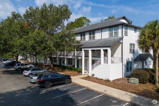
Property Record
122 Sw 62Nd St, Gainesville, FL 32607

Property Detail
122 Sw 62Nd St
06655-002-020
COM SE COR SEC 4-10-19 N 1601.85 FT TO SW R/W SW 62ND ST N 81 DEG W 392.01 FT NWLY ALONG R/W 826.80 FT TO NE COR D NORMAN TRACT POB CONTINUE NLY ALONG R/W 260.93 FT N 133.49 FT W 919.18 FT S 65 FT TO I-75 S 36 DEG E ALONG R/W 652.50 FT N 53 DEG E 250
Multifamilydwelling
ALACHUA
MU1
Florida
B and X Area of moderate flood hazard, usually the area between the limits of the 100-year and 500-year floods.
8.76 AC
2025
West Gainesville
2025
Other Market Areas
001605
Gainesville, FL
195,165 SF
NEARBY LISTINGS FOR SALE OR LEASE
DEMOGRAPHICS near 122 Sw 62Nd St
1 mile
3 mile
5 mile
2025 Total Population
15,381
72,738
183,634
2030 Population
15,831
75,263
190,285
Pop Growth 2025-2030
+ 2.93%
+ 3.47%
+ 3.62%
Average Age
31
36
35
2025 Total Households
6,391
29,861
74,487
HH Growth 2025-2030
+ 3.46%
+ 3.91%
+ 4.16%
Median Household Inc
$39,728
$57,114
$60,656
Avg Household Size
2.20
2.20
2.20
2025 Avg HH Vehicles
1.00
2.00
2.00
Median Home Value
$301,194
$356,789
$349,724
Median Year Built
1986
1987
1989
Nearby Places
Map Layers
Map Styles
 Street
 Aerial
Layers
 Traffic
 Biking
Places
Listings with unknown addresses are not visible on the map
- Restaurants
- Banks
- Shops
- Fitness
- Groceries
PUBLIC TRANSPORTATION
AIRPORT
Gainesville Regional
Drive
Walk
Distance
Gainesville Regional
25 min
11.8 mi
Freight Ports
Jacksonville Port
Drive
Walk
Distance
Jacksonville Port
110 min
81.6 mi
Nearby Properties
Address
Land Use
TOTAL SIZE
Lot Size
Zoning
Address
Land Use
TOTAL SIZE
Lot Size
Zoning
790,340 SF
526 AC
ED
Address
Land Use
TOTAL SIZE
Lot Size
Zoning
317,057 SF
128.93 AC
RP
Address
Land Use
TOTAL SIZE
Lot Size
Zoning
1,005,666 SF
11.60 AC
MD
Address
Land Use
TOTAL SIZE
Lot Size
Zoning
571,635 SF
55.49 AC
RMF6
Address
Land Use
TOTAL SIZE
Lot Size
Zoning
392,241 SF
25 AC
U9
Address
Land Use
TOTAL SIZE
Lot Size
Zoning
141,984 SF
20 AC
HM
Address
Land Use
TOTAL SIZE
Lot Size
Zoning
790,684 SF
57.09 AC
U8
Address
Land Use
TOTAL SIZE
Lot Size
Zoning
392,717 SF
47.62 AC
R-2
Address
Land Use
TOTAL SIZE
Lot Size
Zoning
318,578 SF
21.24 AC
RMF7
Address
Land Use
TOTAL SIZE
Lot Size
Zoning
495,440 SF
14.88 AC
U9
Address
Land Use
TOTAL SIZE
Lot Size
Zoning
153,592 SF
24.98 AC
R-2
Address
Land Use
TOTAL SIZE
Lot Size
Zoning
626,679 SF
41.04 AC
A
Address
Land Use
TOTAL SIZE
Lot Size
Zoning
299,984 SF
10.33 AC
MU2
Address
Land Use
TOTAL SIZE
Lot Size
Zoning
366,764 SF
26.03 AC
RMF6
Address
Land Use
TOTAL SIZE
Lot Size
Zoning
349,789 SF
28.08 AC
PD
Address
Land Use
TOTAL SIZE
Lot Size
Zoning
794,044 SF
80.54 AC
PD
Address
Land Use
TOTAL SIZE
Lot Size
Zoning
170,185 SF
5.14 AC
R-1AA
Address
Land Use
TOTAL SIZE
Lot Size
Zoning
484,466 SF
7.44 AC
U9
Address
Land Use
TOTAL SIZE
Lot Size
Zoning
206,071 SF
43.34 AC
A
Address
Land Use
TOTAL SIZE
Lot Size
Zoning
230,564 SF
6.34 AC
U9
Address
Land Use
TOTAL SIZE
Lot Size
Zoning
332,878 SF
34.15 AC
PD
Address
Land Use
TOTAL SIZE
Lot Size
Zoning
344,284 SF
31.74 AC
PD
Address
Land Use
TOTAL SIZE
Lot Size
Zoning
228,729 SF
8.10 AC
U9
Address
Land Use
TOTAL SIZE
Lot Size
Zoning
22,710 SF
30 AC
ED
Address
Land Use
TOTAL SIZE
Lot Size
Zoning
326,376 SF
39.94 AC
R-2
Address
Land Use
TOTAL SIZE
Lot Size
Zoning
214,608 SF
21.23 AC
MU2
Address
Land Use
TOTAL SIZE
Lot Size
Zoning
272,730 SF
20.13 AC
PD
Address
Land Use
TOTAL SIZE
Lot Size
Zoning
205,916 SF
9.89 AC
U9
Address
Land Use
TOTAL SIZE
Lot Size
Zoning
183,300 SF
11.73 AC
ED
Address
Land Use
TOTAL SIZE
Lot Size
Zoning
232,629 SF
22.60 AC
U9
The World's #1 Commercial Real Estate Marketplace
Connect with us
© 2026 CoStar Group
The information above has been obtained from sources believed reliable. While we do not doubt its accuracy we have not verified it and make no guarantee, warranty or representation about it. It is your responsibility to independently confirm its accuracy and completeness. Any projections, opinions, assumptions, or estimates used are for example only and do not represent the current or future performance of the property. The value of this transaction to you depends on tax and other factors which should be evaluated by your tax, financial, and legal advisors. You and your advisors should conduct a careful, independent investigation of the property to determine to your satisfaction the suitability of the property for your needs.