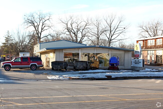
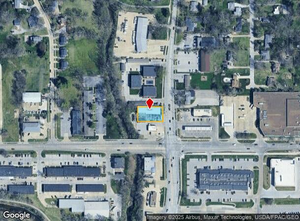
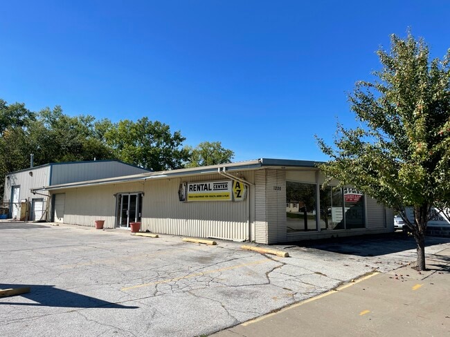
Property Record
1220 73Rd St, Windsor Heights, IA 50324
Current Lease Availabilities
NEARBY LISTINGS FOR SALE OR LEASE
Property Detail
1220 73Rd St
Des Moines-West Des Moines, IA
Mott Place
292-00895000000
N 85F E 150F LOT 27 MOTT PLACE
Storebuilding
Polk
AE
Iowa
19153C0327F
27
2024
0.29 AC
2025
Western Suburbs
011201
Des Moines
5,200 SF
DEMOGRAPHICS near 1220 73Rd St
1 mile
3 mile
5 mile
2024 Total Population
10,569
91,161
198,979
2029 Population
10,867
93,979
207,753
Pop Growth 2024-2029
+ 2.82%
+ 3.09%
+ 4.41%
Average Age
39
40
39
2024 Total Households
4,683
40,072
85,522
HH Growth 2024-2029
+ 3.01%
+ 3.30%
+ 4.74%
Median Household Inc
$59,166
$72,501
$71,366
Avg Household Size
2.20
2.20
2.20
2024 Avg HH Vehicles
2.00
2.00
2.00
Median Home Value
$224,645
$222,960
$235,191
Median Year Built
1966
1966
1975
Nearby Places
Map Layers
Map Styles
 Street
 Aerial
Transit
 Traffic
 Biking
Places
Listings with unknown addresses are not visible on the map
- Restaurants
- Banks
- Shops
- Fitness
- Groceries
PUBLIC TRANSPORTATION
AIRPORT
Des Moines International
Drive
Walk
Distance
Des Moines International
15 min
6.9 mi
Nearby Properties
Address
Land Use
TOTAL SIZE
Lot Size
Zoning
Address
Land Use
TOTAL SIZE
Lot Size
Zoning
255,521 SF
60.90 AC
RE
Address
Land Use
TOTAL SIZE
Lot Size
Zoning
407,183 SF
17.02 AC
PUD
Address
Land Use
TOTAL SIZE
Lot Size
Zoning
415,320 SF
51.16 AC
PUD
Address
Land Use
TOTAL SIZE
Lot Size
Zoning
241,324 SF
21.67 AC
PUD B&C
Address
Land Use
TOTAL SIZE
Lot Size
Zoning
322,220 SF
7.61 AC
Address
Land Use
TOTAL SIZE
Lot Size
Zoning
341,024 SF
12.15 AC
RH
Address
Land Use
TOTAL SIZE
Lot Size
Zoning
444,073 SF
28.05 AC
RH
Address
Land Use
TOTAL SIZE
Lot Size
Zoning
67,691 SF
7.30 AC
Address
Land Use
TOTAL SIZE
Lot Size
Zoning
151,344 SF
10.43 AC
C-3
Address
Land Use
TOTAL SIZE
Lot Size
Zoning
195,931 SF
13.66 AC
Address
Land Use
TOTAL SIZE
Lot Size
Zoning
308,117 SF
18.33 AC
RH
Address
Land Use
TOTAL SIZE
Lot Size
Zoning
80,045 SF
5.07 AC
C-3
Address
Land Use
TOTAL SIZE
Lot Size
Zoning
150,640 SF
2.46 AC
PUD
Address
Land Use
TOTAL SIZE
Lot Size
Zoning
307,734 SF
23.59 AC
R-3
Address
Land Use
TOTAL SIZE
Lot Size
Zoning
235,620 SF
13.18 AC
RH
Address
Land Use
TOTAL SIZE
Lot Size
Zoning
1,164,314 SF
57.72 AC
RC
Address
Land Use
TOTAL SIZE
Lot Size
Zoning
264,418 SF
12.83 AC
COLBY WOOD
Address
Land Use
TOTAL SIZE
Lot Size
Zoning
386,236 SF
9.62 AC
C-4
Address
Land Use
TOTAL SIZE
Lot Size
Zoning
117,272 SF
3.46 AC
R1-60
Address
Land Use
TOTAL SIZE
Lot Size
Zoning
175,810 SF
19.36 AC
RC
Address
Land Use
TOTAL SIZE
Lot Size
Zoning
247,414 SF
15.83 AC
RH
Address
Land Use
TOTAL SIZE
Lot Size
Zoning
192,222 SF
9.27 AC
Address
Land Use
TOTAL SIZE
Lot Size
Zoning
122,676 SF
1.16 AC
Address
Land Use
TOTAL SIZE
Lot Size
Zoning
166,908 SF
8.03 AC
R-3
Address
Land Use
TOTAL SIZE
Lot Size
Zoning
189,506 SF
11.78 AC
PUD HD
Address
Land Use
TOTAL SIZE
Lot Size
Zoning
168,556 SF
10.92 AC
RH
Address
Land Use
TOTAL SIZE
Lot Size
Zoning
125,396 SF
12.89 AC
PUD
Address
Land Use
TOTAL SIZE
Lot Size
Zoning
258,178 SF
5.95 AC
Address
Land Use
TOTAL SIZE
Lot Size
Zoning
88,590 SF
11.22 AC
C-2
Address
Land Use
TOTAL SIZE
Lot Size
Zoning
264,656 SF
9.38 AC
RH
The World's #1 Commercial Real Estate Marketplace
Connect with us
© 2026 CoStar Group
The information above has been obtained from sources believed reliable. While we do not doubt its accuracy we have not verified it and make no guarantee, warranty or representation about it. It is your responsibility to independently confirm its accuracy and completeness. Any projections, opinions, assumptions, or estimates used are for example only and do not represent the current or future performance of the property. The value of this transaction to you depends on tax and other factors which should be evaluated by your tax, financial, and legal advisors. You and your advisors should conduct a careful, independent investigation of the property to determine to your satisfaction the suitability of the property for your needs.