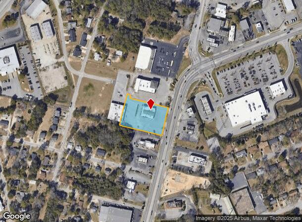
Property Record
1220 Charleston Hwy, West Columbia, SC 29169
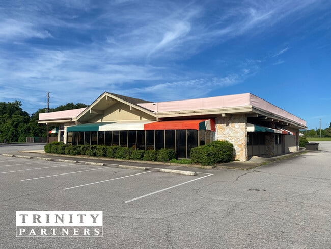
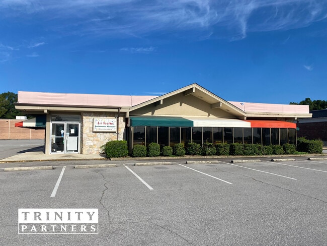
This Property Is For Sale
NEARBY LISTINGS FOR SALE OR LEASE
Property Detail
1220 Charleston Hwy
004632-03-010
180X265X210X170X25X95
Restaurantbuilding
Lexington
X
South Carolina
45063C0277J
1.27 AC
2025
Cayce/West Columbia
2024
Columbia
020601
Columbia, SC
5,131 SF
DEMOGRAPHICS near 1220 Charleston Hwy
1 Mile
3 Mile
5 Mile
2024 Total Population
7,110
54,501
129,798
2029 Population
7,821
58,252
136,717
Pop Growth 2024-2029
+ 10.00%
+ 6.88%
+ 5.33%
Average Age
41
36
37
2024 Total Households
3,315
22,512
57,737
HH Growth 2024-2029
+ 10.20%
+ 7.54%
+ 5.54%
Median Household Inc
$44,608
$47,460
$46,718
Avg Household Size
2.10
2.10
2.00
2024 Avg HH Vehicles
2.00
2.00
2.00
Median Home Value
$151,532
$153,406
$171,811
Median Year Built
1966
1974
1974
Nearby Places
- Restaurants
- Banks
- Shops
- Fitness
- Groceries
PUBLIC TRANSPORTATION
COMMUTER RAIL
Columbia Amtrak Station (Silver Star - Amtrak)
DRIVE
WALK
Distance
Columbia Amtrak Station (Silver Star - Amtrak)
6 min
3.0 mi
AIRPORT
Columbia Metro
DRIVE
WALK
Distance
Columbia Metro
18 min
6.3 mi
Freight Ports
North Charleston Terminal
DRIVE
WALK
Distance
North Charleston Terminal
117 min
102.1 mi
Nearby Properties
Address
Land Use
TOTAL SIZE
Lot Size
Zoning
Address
Land Use
TOTAL SIZE
Lot Size
Zoning
106,284 SF
10.83 AC
C-5
Address
Land Use
TOTAL SIZE
Lot Size
Zoning
413,000 SF
3.48 AC
MC
Address
Land Use
TOTAL SIZE
Lot Size
Zoning
160,510 SF
0.26 AC
DAC
Address
Land Use
TOTAL SIZE
Lot Size
Zoning
311,754 SF
1.78 AC
DAC
Address
Land Use
TOTAL SIZE
Lot Size
Zoning
440,418 SF
7.23 AC
M-1
Address
Land Use
TOTAL SIZE
Lot Size
Zoning
375,417 SF
3.92 AC
INS-GEN
Address
Land Use
TOTAL SIZE
Lot Size
Zoning
30,100 SF
3.45 AC
M-2
Address
Land Use
TOTAL SIZE
Lot Size
Zoning
204,154 SF
1.37 AC
DAC
Address
Land Use
TOTAL SIZE
Lot Size
Zoning
530,349 SF
0.75 AC
DAC
Address
Land Use
TOTAL SIZE
Lot Size
Zoning
119,738 SF
10.30 AC
EC
Address
Land Use
TOTAL SIZE
Lot Size
Zoning
100 SF
9.81 AC
MC
Address
Land Use
TOTAL SIZE
Lot Size
Zoning
311,168 SF
3.98 AC
MC
Address
Land Use
TOTAL SIZE
Lot Size
Zoning
494,384 SF
1.67 AC
MC
Address
Land Use
TOTAL SIZE
Lot Size
Zoning
291,996 SF
0.78 AC
DAC
Address
Land Use
TOTAL SIZE
Lot Size
Zoning
354,235 SF
0.80 AC
DAC
Address
Land Use
TOTAL SIZE
Lot Size
Zoning
490,633 SF
13.20 AC
RM-2
Address
Land Use
TOTAL SIZE
Lot Size
Zoning
163,868 SF
4.35 AC
CAC
Address
Land Use
TOTAL SIZE
Lot Size
Zoning
100 SF
4.24 AC
INS-GEN
Address
Land Use
TOTAL SIZE
Lot Size
Zoning
352,672 SF
5.16 AC
MC
Address
Land Use
TOTAL SIZE
Lot Size
Zoning
316,822 SF
1.53 AC
C-1
Address
Land Use
TOTAL SIZE
Lot Size
Zoning
155,041 SF
3.82 AC
C-4
Address
Land Use
TOTAL SIZE
Lot Size
Zoning
300,130 SF
7.56 AC
RAC
Address
Land Use
TOTAL SIZE
Lot Size
Zoning
228,005 SF
0.40 AC
DAC
Address
Land Use
TOTAL SIZE
Lot Size
Zoning
296,430 SF
0.89 AC
DAC
Address
Land Use
TOTAL SIZE
Lot Size
Zoning
155,883 SF
2.74 AC
MC
Address
Land Use
TOTAL SIZE
Lot Size
Zoning
114,137 SF
0.80 AC
C-3
Address
Land Use
TOTAL SIZE
Lot Size
Zoning
364,000 SF
0.58 AC
DAC
Address
Land Use
TOTAL SIZE
Lot Size
Zoning
22,802 SF
2.64 AC
MC
Address
Land Use
TOTAL SIZE
Lot Size
Zoning
138,832 SF
3.47 AC
C-1
Address
Land Use
TOTAL SIZE
Lot Size
Zoning
155,590 SF
1.18 AC
C-4
The World's #1 Commercial Real Estate Marketplace
Connect with us
© 2025 CoStar Group
The information above has been obtained from sources believed reliable. While we do not doubt its accuracy we have not verified it and make no guarantee, warranty or representation about it. It is your responsibility to independently confirm its accuracy and completeness. Any projections, opinions, assumptions, or estimates used are for example only and do not represent the current or future performance of the property. The value of this transaction to you depends on tax and other factors which should be evaluated by your tax, financial, and legal advisors. You and your advisors should conduct a careful, independent investigation of the property to determine to your satisfaction the suitability of the property for your needs.