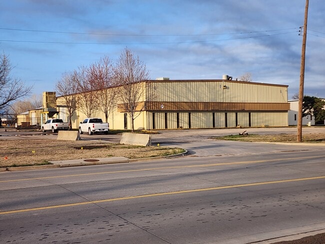
Property Record
1220 E 37Th St N, Wichita, KS 67219
Current Lease Availabilities
NEARBY LISTINGS FOR SALE OR LEASE
Property Detail
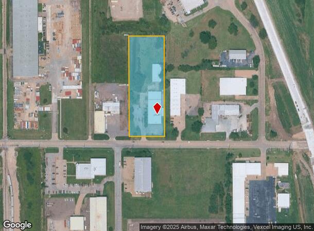
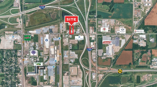
1220 E 37Th St N
Wichita, KS
Subd No.: B05
098-28-0-43-01-011.00
LOT 6 BRIDGEPORT INDUSTRIAL PARK II
Warehouse
Sedgwick
X
Kansas
20173C0214G
6
2024
2.94 AC
2025
Northeast
008100
Wichita
21,958 SF
DEMOGRAPHICS near 1220 E 37Th St N
1 Mile
3 Mile
5 Mile
2024 Total Population
448
41,558
141,176
2029 Population
455
42,299
144,494
Pop Growth 2024-2029
+ 1.56%
+ 1.78%
+ 2.35%
Average Age
34
37
38
2024 Total Households
158
15,405
57,186
HH Growth 2024-2029
+ 1.90%
+ 1.60%
+ 2.39%
Median Household Inc
$45,454
$53,363
$54,693
Avg Household Size
2.80
2.60
2.30
2024 Avg HH Vehicles
2.00
2.00
2.00
Median Home Value
$53,378
$125,963
$154,107
Median Year Built
1956
1962
1967
Nearby Places
Map Layers
Map Styles
 Street
 Aerial
- Restaurants
- Banks
- Shops
- Fitness
- Groceries
PUBLIC TRANSPORTATION
AIRPORT
Wichita Dwight D Eisenhower Ntl
DRIVE
WALK
Distance
Wichita Dwight D Eisenhower Ntl
20 min
12.1 mi
Freight Ports
Tulsa Port Of Catoosa
DRIVE
WALK
Distance
Tulsa Port Of Catoosa
212 min
197.6 mi
Nearby Properties
Address
Land Use
TOTAL SIZE
Lot Size
Zoning
Address
Land Use
TOTAL SIZE
Lot Size
Zoning
481,160 SF
63.37 AC
SF-5
Address
Land Use
TOTAL SIZE
Lot Size
Zoning
924,000 SF
58.58 AC
SF-20
Address
Land Use
TOTAL SIZE
Lot Size
Zoning
346,728 SF
15.91 AC
SF-5
Address
Land Use
TOTAL SIZE
Lot Size
Zoning
179,764 SF
42.17 AC
SF-5,LI
Address
Land Use
TOTAL SIZE
Lot Size
Zoning
304,863 SF
74.13 AC
SF5
Address
Land Use
TOTAL SIZE
Lot Size
Zoning
148,617 SF
17.27 AC
SF-5
Address
Land Use
TOTAL SIZE
Lot Size
Zoning
305,447 SF
46.77 AC
GI
Address
Land Use
TOTAL SIZE
Lot Size
Zoning
186,902 SF
5.24 AC
SF-5
Address
Land Use
TOTAL SIZE
Lot Size
Zoning
199,468 SF
24.45 AC
SF-5
Address
Land Use
TOTAL SIZE
Lot Size
Zoning
147,784 SF
39.28 AC
SF-5
Address
Land Use
TOTAL SIZE
Lot Size
Zoning
180,598 SF
17.41 AC
SF-5
Address
Land Use
TOTAL SIZE
Lot Size
Zoning
92,973 SF
5.52 AC
PUD
Address
Land Use
TOTAL SIZE
Lot Size
Zoning
111,805 SF
20.09 AC
SF-5
Address
Land Use
TOTAL SIZE
Lot Size
Zoning
84,452 SF
0.46 AC
B
Address
Land Use
TOTAL SIZE
Lot Size
Zoning
64,133 SF
5.93 AC
SF-5
Address
Land Use
TOTAL SIZE
Lot Size
Zoning
92,735 SF
7.28 AC
R4
Address
Land Use
TOTAL SIZE
Lot Size
Zoning
66,601 SF
3.85 AC
SF-5
Address
Land Use
TOTAL SIZE
Lot Size
Zoning
72,001 SF
21.99 AC
LI
Address
Land Use
TOTAL SIZE
Lot Size
Zoning
60,945 SF
14.20 AC
SF-5
Address
Land Use
TOTAL SIZE
Lot Size
Zoning
65,680 SF
2.47 AC
SF-5
Address
Land Use
TOTAL SIZE
Lot Size
Zoning
41,798 SF
5.61 AC
PUD
Address
Land Use
TOTAL SIZE
Lot Size
Zoning
87,018 SF
8.38 AC
LC
Address
Land Use
TOTAL SIZE
Lot Size
Zoning
1,179,118 SF
171.49 AC
LI
Address
Land Use
TOTAL SIZE
Lot Size
Zoning
31,655 SF
4.14 AC
GO
Address
Land Use
TOTAL SIZE
Lot Size
Zoning
35,143 SF
0.78 AC
GO
Address
Land Use
TOTAL SIZE
Lot Size
Zoning
66,946 SF
26.81 AC
SF-5,LC
Address
Land Use
TOTAL SIZE
Lot Size
Zoning
87,838 SF
13 AC
SF-5,GO
Address
Land Use
TOTAL SIZE
Lot Size
Zoning
94,251 SF
6.46 AC
C2
Address
Land Use
TOTAL SIZE
Lot Size
Zoning
68,374 SF
8.15 AC
SF-5
Address
Land Use
TOTAL SIZE
Lot Size
Zoning
21,610 SF
4.27 AC
SF-5
The World's #1 Commercial Real Estate Marketplace
Connect with us
© 2025 CoStar Group
The information above has been obtained from sources believed reliable. While we do not doubt its accuracy we have not verified it and make no guarantee, warranty or representation about it. It is your responsibility to independently confirm its accuracy and completeness. Any projections, opinions, assumptions, or estimates used are for example only and do not represent the current or future performance of the property. The value of this transaction to you depends on tax and other factors which should be evaluated by your tax, financial, and legal advisors. You and your advisors should conduct a careful, independent investigation of the property to determine to your satisfaction the suitability of the property for your needs.